
Cycle Route Aigues-Mortes - Nice
No. of cycle route V65
Actions
![]()
Please wait - map data are loading
Added on 30 Jul 2016,
last edited by biroto-Redaktion on 10 Feb 2024
Actions
Cycle route metrics
Total distance in km
553
Information about rights to the gps-track data | |
|---|---|
Rights owner | OpenStreetMap and Contributors + biroto-Redaktion (biroto.eu) |
Rights characteristic / license | Contains information from OpenStreetMap, which is made available here under the Open Database License(ODbL) |
Link to the description of the license | |
GPX file taken from | |
GPX file uploaded | by biroto-Redaktion on 10 Feb 2024
|
Track points in total
10.563
Track points per km (avg)
19
Start/endpoint
Start location
Aigues-Mortes, Occitania, FR (4 m NHN)
End location
Nice, Provence-Alpes-Côte d'Azur, FR (9 m NHN)
Remarks
Bisher verlaufen rund 35% des Tracks auf Trassen, die als "geöffnet" ausgewiesen sind. Für die übrigen 65% ist die Strecke auf möglichst verkehrsarme Straßen und Wege gelegt worden, die nahe der geplanten endgültigen Trassenführung verlaufen.
Zwischen der Rhône-Fähre (43.43775,4.77668) und Fos-sur-Mer (43.4751,4.9777) konnte keine geeignete Trasse gefunden werden. Deshalb folgen wir ab der Fähre dem EV17 bis nach Arles und auf selbst erstelltem Track weiter nach Istres.
Alternativ kann von Arles die Fahrt mit der Bahn bis nach Istres oder Rassuen mit Umstieg in Miramas erfolgen. Preis p.P. ca. 10 €.
Beispielhaft Fahrtmöglichkeiten am 01.06.2018:
Arles | ab 07:32 | TER 876532 | Regionalzug | |
Miramas | an 07:50 | |||
Umsteigezeit 16 Min. | ||||
Miramas | ab 08:06 | TER 879723 | Regionalzug Fahrradmitnahme begrenzt möglich | |
Rassuen | an 08:17 | |||
Arles | ab 10:18 | TER 876538 | Regionalzug | |
Miramas | an 10:41 | |||
Umsteigezeit 58 Min. | ||||
Miramas | ab 11:39 | TER 879731 | Regionalzug Fahrradmitnahme begrenzt möglich | |
Rassuen | an 11:50 | |||
Arles | ab 12:32 | TER 879521 | Regionalzug | |
Miramas | an 12:56 | |||
Umsteigezeit 73 Min. | ||||
Miramas | ab 14:09 | TER 879739 | Regionalzug Fahrradmitnahme begrenzt möglich | |
Rassuen | an 14:20 | |||
Arles | ab 16:00 | TER 17717 | Regionalzug | |
Miramas | an 16:20 | |||
Umsteigezeit 46 Min. | ||||
Miramas | ab 17:06 | TER 879747 | Regionalzug Fahrradmitnahme begrenzt möglich | |
Rassuen | an 17:17 | |||
Arles | ab 18:01 | TER 17721 | Regionalzug | |
Miramas | an 18:22 | |||
Umsteigezeit 17 Min. | ||||
Miramas | ab 18:39 | TER 879753 | Regionalzug Fahrradmitnahme begrenzt möglich | |
Rassuen | an 18:50 | |||
Beds4Cyclists, worth visiting and infrastructure
Name and address
Latitude / Longitude
Phone
Fax
Mobile
Type of accommodation
Rating for cyclists
Route km
Dist. to route
Elevation
0 km
0,2 km
6 m
Hours of opening
From October to March: 9:00 to 17:00 (weekends and holidays from 10:00 to 17:00);
From April to June and September: 9:00 to 18:00 (weekends and public holidays 10:00 to 18:00);
July and August: 09:00 to 19:00.
363 days a year (closed on Christmas Day and New Year).
Languages spoken:
française
0 km
1,8 km
4 m
Information about copyright | |
|---|---|
Rights owner | |
Rights characteristic / license | by-sa: CREATIVE COMMONS Attribution-ShareAlike |
Link to the description of the license | |
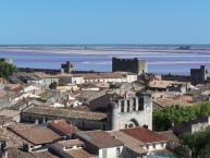
Image taken over from | https://commons.wikimedia.org/wiki/File:Toits_d'Aigues-Mortes.jpg |
Image has been uploaded | by biroto-Redaktion on 06 Aug 2016
|
Information about copyright | |
|---|---|
Rights owner | |
Rights characteristic / license | by-sa: CREATIVE COMMONS Attribution-ShareAlike |
Link to the description of the license | |
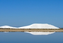
Image taken over from | https://commons.wikimedia.org/wiki/File:Flickr_-_lo.tangelini_-_Saline_Du_Roy_(1).jpg |
Image has been uploaded | by biroto-Redaktion on 06 Aug 2016
|
Information about copyright | |
|---|---|
Rights owner | |
Rights characteristic / license | by: CREATIVE COMMONS Attribution |
Link to the description of the license | |
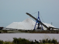
Image taken over from | https://commons.wikimedia.org/wiki/File:Camargue_formation_des_camelles.jpg |
Image has been uploaded | by biroto-Redaktion on 06 Aug 2016
|

Information about copyright | |
|---|---|
Rights owner | |
Rights characteristic / license | by-sa: CREATIVE COMMONS Attribution-ShareAlike |
Link to the description of the license | |
Image taken over from | https://commons.wikimedia.org/wiki/File:Fleur_de_sel_de_camargue.JPG |
Image has been uploaded | by biroto-Redaktion on 06 Aug 2016
|
Die Salin du Midi erinnern daran, dass die Camargue der Hauptgewinnungsort französischen Meersalzes ist. Die Salinen sollen schon in der Antike angelegt worden sein. Im frühen 13. Jahrhundert gehörten fast alle Salinen dem Kloster Psalmody, dessen Überreste in der Gemeinde St-Laurent-d'Aigouze zu finden sind. Die Salinen erstrecken sich heute über eine Fläche von knapp 10.000 ha. Fünf Monate lang kreist das Meerwasser von Becken zu Becken. Nach der Verdunstung des Wassers wird das Salz zu Bergen aufgehäuft, die 20 m hoch und über 400 m lang sind. Die Saline ist einzigartig in Europa und jedenfalls einen Besuch wert. Man kann mit einem kleinen Zug besichtigen und auch das Salzmuseum besuchen.
Preise: Erwachsene € 10,00, Kinder € 8,00.
Information about copyright | |
|---|---|
Rights characteristic / license | by-sa: CREATIVE COMMONS Attribution-ShareAlike |
Link to the description of the license | |
Input taken over from: |
Wikivoyage-Bearbeiter, 'Aigues-Mortes', Wikivoyage, Freie Reiseinformationen rund um die Welt, 28. Juli 2016, 04:43 UTC, <https://de.wikivoyage.org/w/index.php?title=Aigues-Mortes&oldid=942724> [abgerufen am 6. August 2016] |
taken over / edited on | 06 Aug 2016
|
taken over / edited by |
|
Hours of opening
From March 1st to October 30 (except 1st May)
From March 1st to April 2sd and October 1st to October 30th
AM: 10:30 – 11:30
PM: 2:30 – 4:00From April 3rd to July 2sd and August 29th to September 30th
AM: 10:00 – 10:30 – 11:00 – 11:30
PM: 2:00 – 2:30 – 3:00 – 3:30 – 4:00 – 4:30 – 5:00From July 3rd to August 28th
AM: 10:00 – 10:30 – 11:00 – 11:15 – 11:30 – 12:00
PM: 1:30 – 2:00 – 2:30 – 3:00 – 3:30 – 4:00 – 4:30 – 5:00 – 5:30 – 6:00
Duration: 1hour 15 minutes
0 km
0,2 km
4 m
Information about copyright | |
|---|---|
Rights owner | |
Rights characteristic / license | by-sa: CREATIVE COMMONS Attribution-ShareAlike |
Link to the description of the license | |
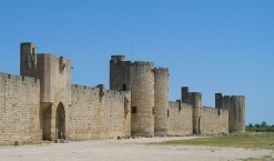
Image taken over from | https://commons.wikimedia.org/wiki/File:Aigues-Mortes_Walls_02.jpg |
Image has been uploaded | by biroto-Redaktion on 15 Feb 2015
|

Information about copyright | |
|---|---|
Rights owner | |
Rights characteristic / license | by-sa: CREATIVE COMMONS Attribution-ShareAlike |
Link to the description of the license | |
Image taken over from | https://commons.wikimedia.org/wiki/File:Aigues_Mortes_-_Tour_de_Constance.jpg |
Image has been uploaded | by biroto-Redaktion on 15 Feb 2015
|
Information about copyright | |
|---|---|
Rights owner | |
Rights characteristic / license | by-sa: CREATIVE COMMONS Attribution-ShareAlike |
Link to the description of the license | |
Image taken over from | https://commons.wikimedia.org/wiki/File:091108_Aigues-Mortes_MG_9229.JPG |
Image has been uploaded | by biroto-Redaktion on 15 Feb 2015
|
Information about copyright | |
|---|---|
Rights owner | |
Rights characteristic / license | cc0: Public Domain no Rights reserved |
Link to the description of the license | |
Image taken over from | |
Image has been uploaded | by biroto-Redaktion on 15 Feb 2015
|
Aigues-Mortes (Occitan: Aigas Mòrtas,) is a French commune in the Gard department in the Languedoc-Roussillon region of southern France.
In 791, Charlemagne erected the Matafère tower amid the swamps for the safety of fishermen and salt workers. Some argue that the signaling and transmission of news was not foreign to the building of this tower which was designed to give warning in case of arrival of a fleet, as for the Magne Tower at Nîmes ![]() .
.
The purpose of this tower was part of the war plan and spiritual plan which Charlemagne granted at the Benedictine abbey, dedicated to Opus Dei (work of God) and whose incessant chanting, day and night, was to designate the convent as Psalmody or Psalmodi. This monastery still existed in 812, as confirmed by an act of endowment made by the Badila from Nîmes at the abbey.
At that time, the people lived in reed huts and made their living from fishing, hunting, and salt production from several small salt marshes along the sea shore. The region was then under the rule of the monks from the Abbey of Psalmody ![]() .
.
In 1240, Louis IX, who wanted to get rid of the influence of the Italian navy for transporting troops to the Crusades, focused on the strategic position of his kingdom. Louis IX wanted direct access to the Mediterranean Sea. He obtained the town and the surrounding lands by exchange of properties with the monks of the abbey. Residents were exempt from the salt tax which was previously levied so that they can now take the salt unconstrained.
He built a road between the marshes and built the Carbonnière Tower to serve as a watchtower and protect access to the city. Saint-Louis then built the Constance Tower on the site of the old Matafère Tower, to house the garrison. In 1272, his son and successor, Philip_III_the_Bold, ordered the continuation of the construction of walls to completely encircle the small town. The work would not be completed for another 30 years.
This was the city from which Louis IX twice departed for the Crusades: the Seventh Crusade in 1248 and again for the Eighth Crusade in 1270 for Tunis where he died of dysentery.
There is a popular belief that the sea reached Aigues-Mortes in 1270. In fact, as confirmed by studies of the engineer Charles Leon Dombre, the whole port of Aigues-Mortes, including the port itself, was in the Marette pond, the Canal-Viel and Grau Louis, the Canal Viel being the access channel to the sea. The Grau-Louis was approximately at the modern location of La Grande-Motte ![]() .
.
At the beginning of 14th century, Philip the Fair used the fortified site to incarcerate the Templars. Between 8 and 11 November 1307, forty-five of them were put to the question, found guilty, and held prisoner in the Tower of Constance.
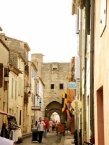
Historical sites
Aigues-Mortes has a very large number of sites registered as historical monuments.
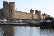
The Tower of Constance and the ramparts
The Tower of Constance was built in 1242 by Saint-Louis on the former site of the Matafère Tower which was built by Charlemagne around 790AD to house the king’s garrison. The construction was completed in 1254.
It is 22 metres in diameter with a height of either 33 or 40 metres depending on the source. The thickness of the walls at the base is 6 metres.
The ramparts stretch for a distance of 1650 metres. Spectacular in their height and their state of preservation even though they were not restored in the 19th century, they remain in a well preserved state. Along with the Tower of Constance, they are a testimony to Western European military architecture in the marshlands during the 13th and 14th centuries.
Information about copyright | |
|---|---|
Rights characteristic / license | by-sa: CREATIVE COMMONS Attribution-ShareAlike |
Link to the description of the license | |
Input taken over from: |
Wikipedia contributors, 'Aigues-Mortes', Wikipedia, The Free Encyclopedia, 21 January 2015, 14:47 UTC, <http://en.wikipedia.org/w/index.php?title=Aigues-Mortes&oldid=643524318> [accessed 15 February 2015] |
taken over / edited on | 15 Feb 2015
|
taken over / edited by |
|
0 km
0,2 km
5 m
0 km
1,5 km
5 m
![]()