Radweg Véloroute de Saint Malo à Rhuys
Nr. des Radweges V3
Aktionen
![]()
Bitte warten - Kartendaten werden geladen
Erstellt am 19.05.2012,
zuletzt geändert von biroto-Redaktion am 06.12.2020
Aktionen
Strecken-Merkmale
Gesamtlänge in km
145
Informationen zu Rechten an den GPS-Track-Daten | |
|---|---|
Rechte-Inhaber | OpenStreetMap and Contributors + biroto-Redaktion (biroto.eu) |
Rechte-Ausprägung / Lizenz | Enthält Daten von OpenStreetMap, die hier unter der Open Database License(ODbL) verfügbar gemacht werden |
Link zur Rechtebeschreibung | |
gpx-Datei übernommen aus | |
gpx-Datei hochgeladen | durch biroto-Redaktion am 06.12.2020
|
Gesamtzahl Trackpoints
1.797
Trackpoint-Dichte per km
12
Endorte
Start
Questembert, Brittany, FR (105 m NHN)
Ziel
Dinard, Brittany, FR (32 m NHN)
Fahrradfreundliche Unterkünfte, Sehenswertes und Infrastruktur
Name u. Anschrift
Breite / Länge
Tel.
Fax.
Mobile
Art d. Unterkunft
Radler-freund-lichkeit
Strecken-km
km zur Strecke
Höhe
0 km
3,2 km
94 m
16 km
1,4 km
17 m
Informationen zu Urheber-Rechten | |
|---|---|
Rechte-Inhaber | |
Rechte-Ausprägung / Lizenz | by-sa: CREATIVE COMMONS Namensnennung, Weitergabe unter gleichen Bedingungen |
Link zur Rechtebeschreibung | |
Bild übernommen aus | |
Bild hochgeladen | durch biroto-Redaktion am 24.04.2015
|
Informationen zu Urheber-Rechten | |
|---|---|
Rechte-Inhaber | |
Rechte-Ausprägung / Lizenz | cc0: Public Domain keine Rechte vorbehalten |
Link zur Rechtebeschreibung | |
Bild übernommen aus | |
Bild hochgeladen | durch biroto-Redaktion am 24.04.2015
|
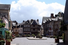
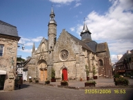
Malestroit (bretonisch Malastred) ist eine französische Gemeinde mit 2497 Einwohnern (2012) im Département Morbihan in der Region Bretagne.
- Man datiert die Gründung von Malestroit im Jahre 987, als sich Mönche an den Ufern des Oust niederließen. Der Ort wird zu einem Etappenziel auf dem Jakobsweg, einem Pilgerweg nach Santiago de Compostela.
- 1131 wird die Stadt urkundlich unter dem Namen Malestricum erwähnt.
- 1343 wird im Rahmen des Hundertjährigen Krieges eine Waffenruhe in der Kapelle de la Madeleine, in Malestroit, vom französischen König Philipp VI. und dem englischen König Eduard III. unterzeichnet.
- Ende des Mittelalters wird Malestroit zu einer der neun Baronien der Bretagne erhoben.
- Anfang des 19.Jh. wird über Auftrag von Napoleon I. mit dem Bau des Canal de Nantes à Brest begonnen, anfänglich aus militärischen Gründen, später auch mit dem Ziel, die innere Bretagne an den Verkehr mit Handelsgütern anzuschließen.
Sehenswürdigkeiten
- Kirche Saint-Gilles (Ursprung aus dem 11.Jh.)
- Kapelle de la Madeleine
- Interessante Innenstadt mit alten Fachwerk- und Steinhäusern
Informationen zu Urheber-Rechten | |
|---|---|
Rechte-Ausprägung / Lizenz | by-sa: CREATIVE COMMONS Namensnennung, Weitergabe unter gleichen Bedingungen |
Link zur Rechtebeschreibung | |
Text(e) übernommen von: |
Seite „Malestroit“. In: Wikipedia, Die freie Enzyklopädie. Bearbeitungsstand: 19. April 2015, 09:22 UTC. URL: http://de.wikipedia.org/w/index.php?title=Malestroit&oldid=140990609 (Abgerufen: 24. April 2015, 10:43 UTC) |
übernommen / bearbeitet am | 24.04.2015
|
übernommen / bearbeitet durch |
|
24 km
1,2 km
70 m
102 km
0,2 km
12 m
Informationen zu Urheber-Rechten | |
|---|---|
Rechte-Inhaber | |
Rechte-Ausprägung / Lizenz | by-sa: CREATIVE COMMONS Namensnennung, Weitergabe unter gleichen Bedingungen |
Link zur Rechtebeschreibung | |
Bild übernommen aus | |
Bild hochgeladen | durch biroto-Redaktion am 23.05.2015
|
Informationen zu Urheber-Rechten | |
|---|---|
Rechte-Inhaber | |
Rechte-Ausprägung / Lizenz | by-sa: CREATIVE COMMONS Namensnennung, Weitergabe unter gleichen Bedingungen |
Link zur Rechtebeschreibung | |
Bild übernommen aus | |
Bild hochgeladen | durch biroto-Redaktion am 23.05.2015
|
Informationen zu Urheber-Rechten | |
|---|---|
Rechte-Inhaber | |
Rechte-Ausprägung / Lizenz | by-sa: CREATIVE COMMONS Namensnennung, Weitergabe unter gleichen Bedingungen |
Link zur Rechtebeschreibung | |
Bild übernommen aus | |
Bild hochgeladen | durch biroto-Redaktion am 23.05.2015
|
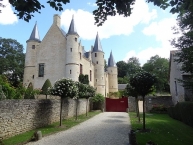
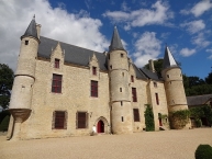
Château de Hac is a fifteenth century castle located on the territory of the municipality of Quiou. It is the subject of a classification as historical monuments.
The castle is open to the public, the tour includes several rooms housing antique furnishings and Gothic style, canopy beds, tapestries, stained-glass window, statues and venery trophies. The visit is completed by a garden of aromatic and medicinal species and Renaissance flowerbeds.
Informationen zu Urheber-Rechten | |
|---|---|
Rechte-Ausprägung / Lizenz | by-sa: CREATIVE COMMONS Namensnennung, Weitergabe unter gleichen Bedingungen |
Link zur Rechtebeschreibung | |
Text(e) übernommen von: |
Contributeurs à Wikipedia, 'Château de Hac', Wikipédia, l'encyclopédie libre, 3 mai 2015, 22:19 UTC, <http://fr.wikipedia.org/w/index.php?title=Ch%C3%A2teau_de_Hac&oldid=114710773> [Page consultée le 23 mai 2015] |
übernommen / bearbeitet am | 23.05.2015
|
übernommen / bearbeitet durch |
|
107 km
0,0 km
10 m
Marie-France Piel et Jean-Pierre Mousquey
FR-22630 Saint-André-des-Eaux-Dolo
Privat/B&B
![]()

