
Cycle Route Voie Verte Roscoff - Concarneau
No. of cycle route V7
Actions
![]()
Please wait - map data are loading
Added on 16 Aug 2012,
last edited by biroto-Redaktion on 16 May 2021
Actions
Cycle route metrics
Total distance in km
146
Information about rights to the gps-track data | |
|---|---|
Rights owner | OpenStreetMap and Contributors + biroto-Redaktion (biroto.eu) |
Rights characteristic / license | Contains information from OpenStreetMap, which is made available here under the Open Database License(ODbL) |
Link to the description of the license | |
GPX file taken from | |
GPX file uploaded | by biroto-Redaktion on 16 May 2021
|
Track points in total
1.967
Track points per km (avg)
13
Start/endpoint
Start location
Roscoff, Brittany, FR (6 m NHN)
End location
Concarneau, Brittany, FR (8 m NHN)
Beds4Cyclists, worth visiting and infrastructure
Name and address
Latitude / Longitude
Phone
Fax
Mobile
Type of accommodation
Rating for cyclists
Route km
Dist. to route
Elevation
0 km
0,4 km
3 m
0 km
0,5 km
8 m
0 km
0,5 km
4 m
0 km
0,0 km
8 m
Hours of opening
From October till March
From Monday to Saturday: 10:00 - 12:00 and 14:00 - 17:00
From April till June and September
From Monday to Saturday: 9:30 - 12:00 and 14:00 - 17:30
In July and August
From Monday to Saturday: 9:30 - 18:30
On Sunday and holydays: 10:00 - 16:00
0 km
0,5 km
6 m
Information about copyright | |
|---|---|
Rights owner | |
Rights characteristic / license | by-sa: CREATIVE COMMONS Attribution-ShareAlike |
Link to the description of the license | |
Image taken over from | |
Image has been uploaded | by biroto-Redaktion on 24 Apr 2015
|
Information about copyright | |
|---|---|
Rights owner | |
Rights characteristic / license | by-sa: CREATIVE COMMONS Attribution-ShareAlike |
Link to the description of the license | |
Image taken over from | commons.wikimedia.org/wiki/File:Notre-Dame_de_Croaz_Batz_-_205.jpg |
Image has been uploaded | by biroto-Redaktion on 24 Apr 2015
|
Information about copyright | |
|---|---|
Rights owner | |
Rights characteristic / license | by-sa: CREATIVE COMMONS Attribution-ShareAlike |
Link to the description of the license | |
Image taken over from | |
Image has been uploaded | by biroto-Redaktion on 24 Apr 2015
|
Information about copyright | |
|---|---|
Rights owner | |
Rights characteristic / license | by-sa: CREATIVE COMMONS Attribution-ShareAlike |
Link to the description of the license | |
Image taken over from | |
Image has been uploaded | by biroto-Redaktion on 24 Apr 2015
|
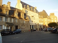
Roscoff (Breton: Rosko) is a commune in the Finistère département of Brittany in northwestern France.
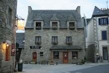
Roscoff is renowned for its picturesque architecture, labeled « Petite cité de caractère de Bretagne (small town of character) » since 2009. Roscoff is also a traditional departure point for Onion Johnnies.
After lobbying by local economic leaders headed by Alexis Gourvennec, the French Government agreed in 1968 to provide a deep water port at Roscoff. Existing ferry operators were reluctant to take on the relatively long Plymouth/Roscoff crossing, so Gourvennec and colleagues founded Brittany Ferries. Since the early 1970s, Roscoff has been developed as a ferry port for the transport of Breton agricultural produce, and for car-based tourism. Brittany Ferries and Irish Ferries link Roscoff with both Ireland and the United Kingdom.
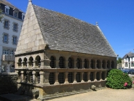
Sights
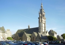
- Roscoff parish church Our Lady of Croaz Batz (Notre Dame de Croaz Batz): Renaissance and Gothic church from the 16th century
- The house known as "that of Mary, Queen of Scots"
- The Station Biologique de Roscoff
 , a research laboratory in oceanography and marine biology.
 - The Jardin Exotique de Roscoff
Information about copyright | |
|---|---|
Rights characteristic / license | by-sa: CREATIVE COMMONS Attribution-ShareAlike |
Link to the description of the license | |
Input taken over from: |
Wikipedia contributors, 'Roscoff', Wikipedia, The Free Encyclopedia, 25 December 2014, 01:07 UTC, <http://en.wikipedia.org/w/index.php?title=Roscoff&oldid=639534820> [accessed 24 April 2015] |
taken over / edited on | 24 Apr 2015
|
taken over / edited by |
|
![]()