
Allgäu Cycle Route
Actions
![]()
Please wait - map data are loading
Added on 23 Jul 2013,
last edited by biroto-Redaktion on 24 Nov 2020
Actions
Cycle route metrics
Total distance in km
151
Information about rights to the gps-track data | |
|---|---|
Rights owner | OpenStreetMap and Contributors + biroto-Redaktion (biroto.eu) |
Rights characteristic / license | Contains information from OpenStreetMap, which is made available here under the Open Database License(ODbL) |
Link to the description of the license | |
GPX file taken from | |
GPX file uploaded | by biroto-Redaktion on 24 Nov 2020
|
Track points in total
3.015
Track points per km (avg)
20
Start/endpoint
Start location
Wangen im Allgäu, Baden-Württemberg, DE (571 m NHN)
End location
Schongau, Bayern, DE (681 m NHN)
Character
Der Allgäu-Radweg ist ein etwa 152 Kilometer langer Verkehrsweg durch das Alpenvorland des Allgäus und Oberbayerns.
Der Allgäu-Radweg startet in Wangen und führt durch Weitnau und Buchenberg über Kempten nach Wildpoldsried und Unterthingau, die Städte Marktoberdorf und Kaufbeuren in das oberbayerische Schongau.
Der Allgäu-Radweg verläuft zum großen Teil auf ehemaligen Bahntrassen oder Straßen durch das Alpenvorland, unter anderem auf der ehemaligen Bahnstrecke Kempten–Isny. Auf der gesamten Strecke sind über 2000 Höhenmeter zu überwinden. Zwischen Wildpoldsried und Unterthingau steht ein anspruchsvoller Anstieg an.
Längere Abschnitte sind nicht asphaltiert, so dass die Route für Rennräder schwierig ist.
Information about copyright | |
|---|---|
Rights characteristic / license | by-sa: CREATIVE COMMONS Attribution-ShareAlike |
Link to the description of the license | |
Input taken over from: |
Seite „Allgäu-Radweg“. In: Wikipedia, Die freie Enzyklopädie. Bearbeitungsstand: 20. Juli 2013, 13:52 UTC. URL: http://de.wikipedia.org/w/index.php?title=Allg%C3%A4u-Radweg&oldid=120723211 (Abgerufen: 23. Juli 2013, 14:37 UTC) |
taken over / edited on | 23 Jul 2013 - 10 Dec 2013
|
taken over / edited by |
|
Sources of information
Bücher:
- Esterbauer bikeline: Radrunde Allgäu mit Allgäu-Radweg und Iller-Radweg
Die Runde in die schönsten Ecken. , 610 km, Radtourenbuch 1:50.000, wetterfest/reißfest
Beds4Cyclists, worth visiting and infrastructure
Name and address
Latitude / Longitude
Phone
Fax
Mobile
Type of accommodation
Rating for cyclists
Route km
Dist. to route
Elevation
0 km
0,9 km
576 m
0 km
0,2 km
565 m
0 km
0,1 km
563 m
Information about copyright | |
|---|---|
Rights owner | https://commons.wikimedia.org/w/index.php?title=User:Husky22 |
Rights characteristic / license | by-sa: CREATIVE COMMONS Attribution-ShareAlike |
Link to the description of the license | |
Image taken over from | https://commons.wikimedia.org/wiki/File:Wangen_Herrenstrasse.JPG |
Image has been uploaded | by biroto-Redaktion on 05 Mar 2021
|
Information about copyright | |
|---|---|
Rights owner | https://commons.wikimedia.org/w/index.php?title=User:SmthingRnd |
Rights characteristic / license | by-sa: CREATIVE COMMONS Attribution-ShareAlike |
Link to the description of the license | |
Image taken over from | https://commons.wikimedia.org/wiki/File:Wangen_im_Allgäu_Marktplatz_1.jpg |
Image has been uploaded | by biroto-Redaktion on 05 Mar 2021
|
Information about copyright | |
|---|---|
Rights owner | |
Rights characteristic / license | by-sa: CREATIVE COMMONS Attribution-ShareAlike |
Link to the description of the license | |
Image taken over from | |
Image has been uploaded | by biroto-Redaktion on 05 Mar 2021
|
Information about copyright | |
|---|---|
Rights owner | |
Rights characteristic / license | by-sa: CREATIVE COMMONS Attribution-ShareAlike |
Link to the description of the license | |
Image taken over from | https://commons.wikimedia.org/wiki/File:Wangen_im_Allgäu_-_Bindstraße_mit_Turm_Sankt_Martin.JPG |
Image has been uploaded | by biroto-Redaktion on 05 Mar 2021
|
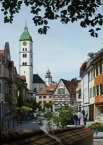
Wangen im Allgäu is a city with around 27,000 inhabitants in Baden Württemberg, Germany. The Landesgartenschau will take place here in 2024.
Understand
The city was first mentioned in 815 (and therefore celebrated its 1200th birthday in 2015). The old town (city centre) is well preserved and features buildings from the early middle ages until the late baroque era.
See
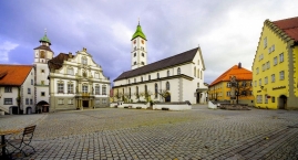
- ⊙City Hall (Rathaus). The oldest parts of the city hall are from the Staufen era (around 11-13th century). In 1721 the Baroque facade which you can see from the market square was added.
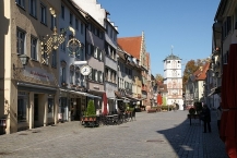
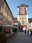
- ⊙Martinstor (Lindauer Tor). A gate which was first mentioned in 1347, but its current form is from 1608. It is also referred to as Lindauer Tor, since the street that starts from the gate leads to Lindau
 .
. - ⊙Frauentor (Ravensburger Tor).
- ⊙Kornhaus, Postplatz. Built in 1600, this building was used as storage facility for grain. Nowadays it houses the public library.
- ⊙Stadtmuseum (City Museum), Eselberg 1, ☎ +49 7522 912682. The city museum includes several exhibitions in various buildings that can all be reached from the main building (the old mill with the still functioning mill wheel). The exhibitions include a cheese museum, mechanical instruments, a historic public bath which was used for bathing and curing diseases, a printing museum and more. (updated Sep 2017)
Information about copyright | |
|---|---|
Rights characteristic / license | by-sa: CREATIVE COMMONS Attribution-ShareAlike |
Link to the description of the license | |
Input taken over from: |
Wikivoyage contributors, 'Wangen im Allgäu', Wikivoyage, The FREE worldwide travel guide that anyone can edit, 3 December 2020, 23:28 UTC, https://en.wikivoyage.org/w/index.php?title=Wangen_im_Allg%C3%A4u&oldid=4108627 [accessed 4 March 2021] |
taken over / edited on | 04 Mar 2021
|
taken over / edited by |
|
1 km
0,1 km
563 m
Hours of opening
Montag - Freitag: 9.00 Uhr - 17.00 Uhr
Juni bis September
zusätzlich Samstag: 9.00 Uhr - 12.00 Uhr
1 km
0,4 km
579 m
![]()