
Altmühl Valley Cycle Route
Actions
![]()
Please wait - map data are loading
Added on 13 Oct 2011,
last edited by biroto-Redaktion on 23 Feb 2024
Actions
Cycle route metrics
Total distance in km
243
Information about rights to the gps-track data | |
|---|---|
Rights owner | OpenStreetMap and Contributors + biroto-Redaktion (biroto.eu) |
Rights characteristic / license | Contains information from OpenStreetMap, which is made available here under the Open Database License(ODbL) |
Link to the description of the license | |
GPX file taken from | |
GPX file uploaded | by biroto-Redaktion on 23 Feb 2024
|
Track points in total
4.277
Track points per km (avg)
18
Start/endpoint
Start location
Rothenburg ob der Tauber, Bayern, DE (430 m NHN)
End location
Kelheim, Bayern, DE (344 m NHN)
Character
Der Altmühltalradweg (auch Altmühltal-Radweg oder kurz Altmühlweg genannt) ist ein insgesamt etwa 250 km langer Fernradweg in Bayern. Er erstreckt sich von Rothenburg ob der Tauber ![]() jenseits der kontinentalen Wasserscheide im Nordwesten nach Kelheim
jenseits der kontinentalen Wasserscheide im Nordwesten nach Kelheim ![]() an der Mündung der Altmühl
an der Mündung der Altmühl ![]() in die Donau im Südosten. Der Geografie des Altmühltals
in die Donau im Südosten. Der Geografie des Altmühltals ![]() entsprechend besteht die Route landschaftlich aus zwei verschiedenen Teilen: Der nordwestlich von Treuchtlingen
entsprechend besteht die Route landschaftlich aus zwei verschiedenen Teilen: Der nordwestlich von Treuchtlingen ![]() in Franken
in Franken ![]() verlaufende Teil beginnt im Taubergrund
verlaufende Teil beginnt im Taubergrund ![]() , dem weiten Talbecken der oberen Tauber, überquert mit einem Anstieg von weniger als 100 Höhenmetern die Frankenhöhe
, dem weiten Talbecken der oberen Tauber, überquert mit einem Anstieg von weniger als 100 Höhenmetern die Frankenhöhe ![]() und führt dann fast eben durch das weite Talbecken der oberen Altmühl. Südöstlich von Treuchtlingen folgt der Radwanderweg den zahlreichen Windungen des engen, in den Fränkischen Jura
und führt dann fast eben durch das weite Talbecken der oberen Altmühl. Südöstlich von Treuchtlingen folgt der Radwanderweg den zahlreichen Windungen des engen, in den Fränkischen Jura ![]() eingeschnittenen unteren Altmühltals, dessen steile Hänge zahlreiche bizarre Felsformationen aufweisen.
eingeschnittenen unteren Altmühltals, dessen steile Hänge zahlreiche bizarre Felsformationen aufweisen.
1979 gegründet und seither in vielen Abschnitten verbessert, ist der Altmühlweg einer der ältesten und laut der Radreiseanalyse des ADFC beliebtesten Radfernwege in Deutschland.
Information about copyright | |
|---|---|
Rights characteristic / license | by-sa: CREATIVE COMMONS Attribution-ShareAlike |
Link to the description of the license | |
Input taken over from: |
Seite „Altmühltalradweg“. In: Wikipedia, Die freie Enzyklopädie. Bearbeitungsstand: 24. Juni 2012, 00:08 UTC. URL: http://de.wikipedia.org/w/index.php?title=Altm%C3%BChltalradweg&oldid=104733870 |
taken over / edited on | 18 Dec 2012 - 23 Feb 2024
|
taken over / edited by |
|
Signposting
|
|

Sources of information
Portale:
- Altmühltal-Radweg auf der Seite des Naturparks-Altmühltal
Bücher:
- Esterbauer bikeline: Altmühl-Radweg
Von Rothenburg ob der Tauber nach Kelheim an der Donau. Radtourenbuch 1: 50 000, 250 km, wetterfest/reißfest
Connecting cycle path
- near Rothenburg
- near Windelsbach Paneuropa-Radweg Paris - Prag (PAN)
- in Gunzenhausen Deutscher Limes-Radweg
- near Kipfenberg Deutscher Limes-Radweg
- near Kinding Ostsee - Oberbayern (D11)
- near Beilngries Fünf-Flüsse-Radweg
- near Kehlheim
Beds4Cyclists, worth visiting and infrastructure
Name and address
Latitude / Longitude
Phone
Fax
Mobile
Type of accommodation
Rating for cyclists
Route km
Dist. to route
Elevation
0 km
0,1 km
428 m
0 km
0,0 km
423 m
Information about copyright | |
|---|---|
Rights owner | |
Rights characteristic / license | cc0: Public Domain no Rights reserved |
Link to the description of the license | |
Image taken over from | |
Image has been uploaded | by biroto-Redaktion on 30 Dec 2012
|
Information about copyright | |
|---|---|
Rights owner | |
Rights characteristic / license | cc0: Public Domain no Rights reserved |
Link to the description of the license | |
Image taken over from | |
Image has been uploaded | by biroto-Redaktion on 30 Dec 2012
|
Information about copyright | |
|---|---|
Rights owner | |
Rights characteristic / license | by-sa: CREATIVE COMMONS Attribution-ShareAlike |
Link to the description of the license | |
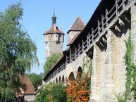
Image taken over from | commons.wikimedia.org/wiki/File:Rothenburg_ob_der_Tauber,_Stadtbefestigung_mit_Klingentorturm.jpg |
Image has been uploaded | by biroto-Redaktion on 30 Dec 2012
|
Information about copyright | |
|---|---|
Rights owner | |
Rights characteristic / license | by-sa: CREATIVE COMMONS Attribution-ShareAlike |
Link to the description of the license | |
Image taken over from | commons.wikimedia.org/wiki/File:RodT_Kirche,_Rathaus,_etc_6930.jpg |
Image has been uploaded | by biroto-Redaktion on 30 Dec 2012
|
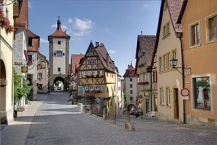
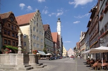
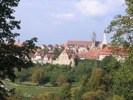
Rothenburg ob der Tauber (German pronunciation: [ˈʁoːtənbʊɐ̯k ɔp deːɐ̯ ˈtaʊbɐ]) is a town in the district of Ansbach ![]() of Mittelfranken (Middle Franconia), the Franconia region of Bavaria, Germany, well known for its well-preserved medieval old town, a destination for tourists from around the world.
of Mittelfranken (Middle Franconia), the Franconia region of Bavaria, Germany, well known for its well-preserved medieval old town, a destination for tourists from around the world.
Rothenburg was a Free Imperial City from the late Middle Ages to 1803.
Main sights
Museums
- ⊙ The Criminal Museum (Kriminalmuseum) gives an insight into judicial punishment over the last 1000 years. Exhibits include instruments of torture, shrew's fiddles, scold's bridles, medieval legal texts and guidance on witch trials.
- ⊙ Imperial City Museum (Reichsstadtmuseum) with the municipal collections and a weapon collection
- Doll and Toy Museum (Puppen- und Spielzeugmuseum)
- Schäfertanz Museum
- ⊙ Christmas Museum
 (Weihnachtsmuseum)
 - ⊙Craft House (Handwerkerhaus) which shows the everyday life of craftsmen's families in Rothenburg in 11 rooms.
- ⊙Historical vaulting and state dungeon
Buildings
- ⊙ St. James' Church with its Holy Blood reredos by Tilman Riemenschneider, another Riemenschneider altar (Altar of the Holy Cross) is in the Detwang church.
- Town wall
- ⊙Plönlein
- ⊙Spital bastion
- ⊙St. Wolfgang's Church by the Klingentor gate (fortified church)
- Great hall of the castle (St. Blasius' Chapel)
- ⊙Toppler Castle in the Tauber valley
- Double bridge over the Tauber
- ⊙Historic town hall with clock tower and Meistertrunk clock
- ⊙ Altes Brauhaus
- Old Smithy
- Old Town Hall
- Monastery
- Franciscan church
Information about copyright | |
|---|---|
Rights characteristic / license | by-sa: CREATIVE COMMONS Attribution-ShareAlike |
Link to the description of the license | |
Input taken over from: |
Wikipedia contributors, 'Rothenburg ob der Tauber', Wikipedia, The Free Encyclopedia, 28 November 2016, 02:40 UTC, https://en.wikipedia.org/w/index.php?title=Rothenburg_ob_der_Tauber&oldid=751833904 |
taken over / edited on | 12 Dec 2016 - 10 Jun 2021
|
taken over / edited by |
|
0 km
0,5 km
412 m
0 km
0,2 km
397 m
0 km
0,5 km
406 m
![]()