
Danube-Lake Constance Cycle Route
Actions
![]()
Please wait - map data are loading
Added on 25 Mar 2021,
last edited by biroto-Redaktion on 11 Feb 2024
Actions
Cycle route metrics
Total distance in km
153
Information about rights to the gps-track data | |
|---|---|
Rights owner | OpenStreetMap and Contributors + biroto-Redaktion (biroto.eu) |
Rights characteristic / license | Contains information from OpenStreetMap, which is made available here under the Open Database License(ODbL) |
Link to the description of the license | |
GPX file taken from | |
GPX file uploaded | by biroto-Redaktion on 11 Feb 2024
|
Track points in total
3.228
Track points per km (avg)
21
Start/endpoint
Start location
Ulm, Baden-Württemberg, DE (477 m NHN)
End location
Kressbronn am Bodensee, Baden-Württemberg, DE (400 m NHN)
Signposting
|

Beds4Cyclists, worth visiting and infrastructure
Name and address
Latitude / Longitude
Phone
Fax
Mobile
Type of accommodation
Rating for cyclists
Route km
Dist. to route
Elevation
0 km
0,5 km
485 m
0 km
1,3 km
480 m
0 km
0,0 km
476 m
0 km
0,6 km
465 m
Information about copyright | |
|---|---|
Rights owner | |
Rights characteristic / license | by-sa: CREATIVE COMMONS Attribution-ShareAlike |
Link to the description of the license | |
Image taken over from | |
Image has been uploaded | by biroto-Redaktion on 16 Feb 2013
|
Information about copyright | |
|---|---|
Rights owner | |
Rights characteristic / license | by: CREATIVE COMMONS Attribution |
Link to the description of the license | |
Image taken over from | |
Image has been uploaded | by biroto-Redaktion on 16 Feb 2013
|
Information about copyright | |
|---|---|
Rights owner | |
Rights characteristic / license | by-sa: CREATIVE COMMONS Attribution-ShareAlike |
Link to the description of the license | |
Image taken over from | commons.wikimedia.org/wiki/File:Schiefes_Haus_und_Ulmer_Münz_Ulm_Fischerviertel.jpg |
Image has been uploaded | by biroto-Redaktion on 16 Feb 2013
|
Information about copyright | |
|---|---|
Rights owner | |
Rights characteristic / license | by-sa: CREATIVE COMMONS Attribution-ShareAlike |
Link to the description of the license | |
Image taken over from | |
Image has been uploaded | by biroto-Redaktion on 16 Feb 2013
|
Ulm ist eine an der Donau am südöstlichen Rand der Schwäbischen Alb an der Grenze zu Bayern gelegene Universitätsstadt in Baden-Württemberg.
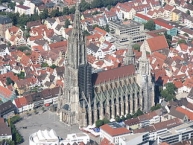
Die Stadt ist bekannt für ihr gotisches ⊙Münster ![]() , dessen Kirchturm mit 161,53 Metern der höchste der Welt ist. Weiterhin bemerkenswert ist die lange bürgerliche Tradition Ulms mit der ältesten Verfassung einer deutschen Stadt und einem Stadttheater, dessen Anfänge bis ins Jahr 1641 zurückreichen.
, dessen Kirchturm mit 161,53 Metern der höchste der Welt ist. Weiterhin bemerkenswert ist die lange bürgerliche Tradition Ulms mit der ältesten Verfassung einer deutschen Stadt und einem Stadttheater, dessen Anfänge bis ins Jahr 1641 zurückreichen.
Bis zum Zweiten Weltkrieg war das Stadtbild Ulms geprägt von einer jahrhundertealten reichsstädtischen Baukultur mit zahlreichen Baudenkmälern vor allem aus Gotik, Renaissance und Historismus und einigen barocken und klassizistischen Bauten. Die mittelalterliche Altstadt Ulms zählte zu den größten und bedeutendsten in Süddeutschland. Diese Traditionslinie brach gegen Ende des Zweiten Weltkrieges mit der weitgehenden Zerstörung Ulms durch Luftangriffe am 17. Dezember 1944 abrupt ab.
Sehenswürdikeiten
Die ⊙Touristinformation ![]() im Stadthaus bietet die UlmCard für 12 Euro (1 Tag) an. Damit hat man Eintritt in 7 Museen in Ulm und Neu-Ulm, kann kostenlos an der öffentlichen Stadtführung teilnehmen, den Nahverkehr umsonst nutzen und viele weitere Vergünstigungen.
im Stadthaus bietet die UlmCard für 12 Euro (1 Tag) an. Damit hat man Eintritt in 7 Museen in Ulm und Neu-Ulm, kann kostenlos an der öffentlichen Stadtführung teilnehmen, den Nahverkehr umsonst nutzen und viele weitere Vergünstigungen.
Stadtmitte
Das gotische ⊙Münster ![]() beherrscht das Stadtbild. Des Weiteren prägen die Stadtsilhouette die 1617 bis 1621 erbaute ⊙Dreifaltigkeitskirche
beherrscht das Stadtbild. Des Weiteren prägen die Stadtsilhouette die 1617 bis 1621 erbaute ⊙Dreifaltigkeitskirche ![]() , nach dem Brand von 1944 stark verändert wiederaufgebaut und heute als Haus der Begegnung für Konzerte, Seminare, Theater und Vorträge genutzt. Auffällig sind ferner die Türme der evangelischen Garnisonskirche Pauluskirche
, nach dem Brand von 1944 stark verändert wiederaufgebaut und heute als Haus der Begegnung für Konzerte, Seminare, Theater und Vorträge genutzt. Auffällig sind ferner die Türme der evangelischen Garnisonskirche Pauluskirche ![]() , die innerhalb von zwei Jahren (1908–1910) von Theodor Fischer im Jugendstil erbaut wurde. Die neugotische St.-Georgs-Kirche
, die innerhalb von zwei Jahren (1908–1910) von Theodor Fischer im Jugendstil erbaut wurde. Die neugotische St.-Georgs-Kirche ![]() , welche 1904 durch Max Meckel als katholische Garnisonkirche
, welche 1904 durch Max Meckel als katholische Garnisonkirche ![]() erbaut wurde und später Pfarrkirche wurde, ist ebenfalls weithin sichtbar.
erbaut wurde und später Pfarrkirche wurde, ist ebenfalls weithin sichtbar.
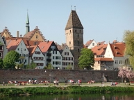
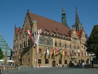
Die beiden ehemaligen Stadttore Gänsturm und ⊙Metzgerturm ![]() prägen das Donauufer. In der historischen Altstadt haben sich trotz der Bombenangriffe des Zweiten Weltkrieges einige Gebäude erhalten, darunter das 1370 erbaute ⊙Rathaus
prägen das Donauufer. In der historischen Altstadt haben sich trotz der Bombenangriffe des Zweiten Weltkrieges einige Gebäude erhalten, darunter das 1370 erbaute ⊙Rathaus ![]() . Das Steinhaus ist das älteste noch erhaltene Gebäude der Stadt und stammt aus dem 12. bis 13. Jahrhundert. Ein Fachwerkbau mit spätgotischem Ziegelgiebel von 1485 ist der Büchsenstadel, der das Jugendhaus Mitte sowie das nichtkommerzielle Lokalradio „Radio freeFM“ beherbergt. Der Gasthof zur Krone ist ein imposanter Gebäudekomplex aus dem 16. Jahrhundert mit Anteilen und baulichen Ergänzungen aus dem 19. Jahrhundert, er wurde im 15. und 16. Jahrhundert als Pfalzersatz für Könige und Kaiser genutzt. Das ⊙Kornhaus
. Das Steinhaus ist das älteste noch erhaltene Gebäude der Stadt und stammt aus dem 12. bis 13. Jahrhundert. Ein Fachwerkbau mit spätgotischem Ziegelgiebel von 1485 ist der Büchsenstadel, der das Jugendhaus Mitte sowie das nichtkommerzielle Lokalradio „Radio freeFM“ beherbergt. Der Gasthof zur Krone ist ein imposanter Gebäudekomplex aus dem 16. Jahrhundert mit Anteilen und baulichen Ergänzungen aus dem 19. Jahrhundert, er wurde im 15. und 16. Jahrhundert als Pfalzersatz für Könige und Kaiser genutzt. Das ⊙Kornhaus ![]() ist ein Renaissancebau von 1594 mit reicher Sgraffito-Verzierung. Der letzte erhaltene Patrizierbau ist das Kiechelhaus, welches heute zum Gebäudekomplex des Ulmer Museums gehört. Der Neue Bau
ist ein Renaissancebau von 1594 mit reicher Sgraffito-Verzierung. Der letzte erhaltene Patrizierbau ist das Kiechelhaus, welches heute zum Gebäudekomplex des Ulmer Museums gehört. Der Neue Bau ![]() , ein von 1584 bis 1593 als Lagerhaus mit Amtszimmer und Ratsstube erbauter Backsteinbau, ist heute Sitz der Polizeidirektion. Ein durch Ulrich Ehinger erweiterter Bau ist der Reichenauer Hof
, ein von 1584 bis 1593 als Lagerhaus mit Amtszimmer und Ratsstube erbauter Backsteinbau, ist heute Sitz der Polizeidirektion. Ein durch Ulrich Ehinger erweiterter Bau ist der Reichenauer Hof ![]() . Ulms Lage an der Salzstraße führte 1592 zur Errichtung eines Salzstadels. Seit 1991 ist dieser Sitz des ⊙Museums der Brotkultur
. Ulms Lage an der Salzstraße führte 1592 zur Errichtung eines Salzstadels. Seit 1991 ist dieser Sitz des ⊙Museums der Brotkultur ![]() .
.
Der ursprünglich als Pfleghof des Klosters Ochsenhausen ![]() errichtete Ochsenhäuser Hof wurde um 1500 erbaut. Das ehemalige Zunfthaus der Schuhmacher, das Schuhhaus, wurde 1537 hinter dem Chor des Münsters errichtet und beherbergt heute den Kunstverein Ulm, der ihn für Kunstausstellungen nutzt. Jeden Juli ist das ⊙Schwörhaus
errichtete Ochsenhäuser Hof wurde um 1500 erbaut. Das ehemalige Zunfthaus der Schuhmacher, das Schuhhaus, wurde 1537 hinter dem Chor des Münsters errichtet und beherbergt heute den Kunstverein Ulm, der ihn für Kunstausstellungen nutzt. Jeden Juli ist das ⊙Schwörhaus ![]() Mittelpunkt des Ulmer Schwörmontags
Mittelpunkt des Ulmer Schwörmontags ![]() . Es wurde 1612 erbaut und nach einem Brand 1785 mit einem Barockgiebel versehen. 1944 wiederum ausgebrannt, wurde es bis 1954 mit modernen Innenräumen wiederaufgebaut. Heute befindet sich darin das Stadtarchiv.
. Es wurde 1612 erbaut und nach einem Brand 1785 mit einem Barockgiebel versehen. 1944 wiederum ausgebrannt, wurde es bis 1954 mit modernen Innenräumen wiederaufgebaut. Heute befindet sich darin das Stadtarchiv.
Aus der jüngsten Ulmer Baugeschichte sind zwei Bauten herausragend: die Neue Zentralbibliothek, 2004 in Form einer gläsernen Pyramide errichtet, etwa 23 Meter hoch, unmittelbar neben dem historischen Rathaus gelegen, sowie das Stadthaus ![]() am Münsterplatz, 1993 trotz der mehrheitlichen Ablehnung des Projektes in einem Bürgerentscheid nach dem Entwurf des New Yorker Architekten Richard Meier erbaut, „begehbare Skulptur“, Platz für Ausstellungen, Konzerte, Tagungen, Vorträge etc. Ebenso ist zu nennen die ⊙Kunsthalle Weishaupt
am Münsterplatz, 1993 trotz der mehrheitlichen Ablehnung des Projektes in einem Bürgerentscheid nach dem Entwurf des New Yorker Architekten Richard Meier erbaut, „begehbare Skulptur“, Platz für Ausstellungen, Konzerte, Tagungen, Vorträge etc. Ebenso ist zu nennen die ⊙Kunsthalle Weishaupt ![]() , unmittelbar dem Museum und dem Rathaus benachbart, in Ulms „Neuer Mitte“.
, unmittelbar dem Museum und dem Rathaus benachbart, in Ulms „Neuer Mitte“.
Auf zwei weitere Kirchenbauten ist zu verweisen: Die Martin-Luther-Kirche ![]() als bedeutendes Bauwerk im Stil des Expressionismus, 1928 durch Theodor Veil erbaut, sowie auf St. Michael zu den Wengen
als bedeutendes Bauwerk im Stil des Expressionismus, 1928 durch Theodor Veil erbaut, sowie auf St. Michael zu den Wengen ![]() (der Wengenkirche). Die ehemalige barocke Klosterkirche von 1399 ist 1944 ausgebrannt; in der 1954 neu erbauten Kirche findet sich ein 1766 von Franz Martin Kuen gemaltes Altarbild und in der Barockkapelle von 1629 eine spätgotische Kreuzigungsgruppe.
(der Wengenkirche). Die ehemalige barocke Klosterkirche von 1399 ist 1944 ausgebrannt; in der 1954 neu erbauten Kirche findet sich ein 1766 von Franz Martin Kuen gemaltes Altarbild und in der Barockkapelle von 1629 eine spätgotische Kreuzigungsgruppe.
Ulms Stadtmauer, um 1480 in die Donau hinein („mitten im reißenden Fluss“) erbaut; später nach den Vorstellungen Albrecht Dürers vom Festungsbau durch Hans Beham d. Ä. (Nürnberger Baumeister) umgebaut, ist heute ein schöner, 600 Meter langer Promenadenweg, der flussaufwärts an der Wilhelmshöhe – Bastion Lauseck endet, einem Teil der Stadtbefestigung aus dem 16.–18. Jahrhundert. Zu diesem Teil der alten Stadtmauer gehört auch die optisch völlig unauffällige Adlerbastei, der Platz, von dem aus 1811 Albrecht Berblinger (Der Schneider von Ulm) seinen erzwungenen, gescheiterten Flugversuch über die Donau startete. Der Teil der Stadtmauer an den heutigen Straßen „Neuer Graben“, „Frauengraben“ und „Seelengraben“ wurde ab 1610 mit Soldatenunterkünften bebaut, nachdem durch den Niederländer Valckenburgh eine neue Befestigung Ulms geplant und umgesetzt wurde, welche die alte Stadtmauer praktisch in die Stadt hereinnahm. Die „Grabenhäusle“ bilden, modernisiert, heute ein Wohnquartier mit eigenem Flair. Im Bereich des Fischerviertels findet man die Staufermauer an der Blau, ab etwa 1150 erbaut. Sie sind Reste der Befestigungsanlage der Ulmer Königspfalz und die ältesten erhaltenen Bauten in der Stadt.
Fischer- und Gerberviertel
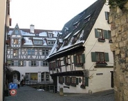
In diesem im Mittelalter vorwiegend von Handwerkern besiedelten Quartier am Donauzufluss der Blau finden sich noch viele aus dieser Zeit stammenden und auf sie verweisende Bauten, so die Garnsiede auf der Blauinsel, das heute genauso wie die Lochmühle und das Gerberhaus gastronomisch genutzte Zunfthaus der Schiffsleute. Weiter nennenswert sind die Ulmer Münz, das um 1500 gebaute Kässbohrersche Haus und, der Ulmer Münz direkt benachbart, das ⊙Schiefe Haus ![]() , im 14. Jahrhundert erbaut, heute ein Hotel, welches als schiefstes der Welt gilt.
, im 14. Jahrhundert erbaut, heute ein Hotel, welches als schiefstes der Welt gilt.
Auf dem Kreuz
Etwa die Hälfte der Bauten in diesem mittelalterlichen Altstadtviertel, welches sich in den letzten 20 Jahren zu einem bevorzugten, weil verkehrsberuhigten und zentrumnahen Wohnquartier entwickelt hat, stammt aus der Zeit vor 1700. Zu den nennenswerteren gezählt werden kann die Sebastiankapelle, erstmals 1415 in der Stadtgeschichte erwähnt, jetzt ein Ausstellungsraum. Außerdem der ⊙Seelturm ![]() , der im 14. Jahrhundert auf der Ulmer Stadtmauer errichtet wurde und ab 1638 als Pumpwerk diente, welches Wasser in das nebenstehende – achteckige – Brunnenhaus pumpte und dort speicherte. Der Name Seelturm kam von einem Seelhaus direkt gegenüber, das im Krieg zerstört wurde. Zu nennen weiterhin das Zundeltor, das 1870 unterhalb des Seelturms erbaut wurde und heute immer noch einen (neo)gotischen Stil aufweist. Außerdem befindet sich am Rande dieses Viertels das ⊙Zeughaus
, der im 14. Jahrhundert auf der Ulmer Stadtmauer errichtet wurde und ab 1638 als Pumpwerk diente, welches Wasser in das nebenstehende – achteckige – Brunnenhaus pumpte und dort speicherte. Der Name Seelturm kam von einem Seelhaus direkt gegenüber, das im Krieg zerstört wurde. Zu nennen weiterhin das Zundeltor, das 1870 unterhalb des Seelturms erbaut wurde und heute immer noch einen (neo)gotischen Stil aufweist. Außerdem befindet sich am Rande dieses Viertels das ⊙Zeughaus ![]() , ehemaliges Waffenarsenal der Reichsstadt Ulm, welches ab 1522 in mehreren Etappen erbaut wurde. Große Teile wurden 1945 zerstört. In der Säulenhalle des zum Komplex gehörenden, unzerstört durch alle Kriege gekommenen frühbarocken „Löwenbaus“ von 1667 finden wechselnde Ausstellungen statt.
, ehemaliges Waffenarsenal der Reichsstadt Ulm, welches ab 1522 in mehreren Etappen erbaut wurde. Große Teile wurden 1945 zerstört. In der Säulenhalle des zum Komplex gehörenden, unzerstört durch alle Kriege gekommenen frühbarocken „Löwenbaus“ von 1667 finden wechselnde Ausstellungen statt.
Museen und Ausstellungen
- ⊙ Im Museum der Brotkultur (früher: Deutsches Brotmuseum) wird die Geschichte des Brotes dokumentiert, es werden aber auch die kulturellen und sozialen Aspekte von Brot und Backen verdeutlicht. · Adresse: Salzstadelgasse 10, 89073 Ulm, · Telefon: 0731-69955
- ⊙ In der Kunsthalle Weishaupt am Hans und Sophie Scholl Platz in Ulms neuer Mitte sind wechselnde Ausstellungen mit Werken aus der Privatsammlung Siegfried Weishaupts zu sehen. In dieser Sammlung werden unter anderem Werke von Andy Warhol, Robert Longo, Keith Haring, Yaakov Agam, Frank Stella und anderen gezeigt. Die Sammlung ist durch einem Übergang mit dem Ulmer Museum verbunden. · Geöffnet ist die Kunsthalle von Dienstag - Sonntag jeweils von 11 - 17 Uhr (donnerstags bis 20:00). · Der Eintritt beträgt 6 € (10 € für das Kombiticket Kunsthalle und Ulmer Museum) bzw. 4 € (7,50 €) für Ermäßigungsberechtigte. Für Kinder bis 14 Jahren ist der Eintritt frei.
- ⊙Ulmer Museum - Das 1924 gegründete 'Ulmer Museum' am Marktplatz gegenüber dem Rathaus zeigt archäologische Fundstücke aus der Ur- und Frühgeschichte des Ulmer Raumes, unter anderem den "Löwenmenschen" der mit ca. 30.000 Jahren die älteste Tier/ Mensch-Plastik der Welt. Weitere Exponate aus der Ulmer Spätgotik und der Sammlung Kurt Fried mit bedeutenden Werken der europäischen und amerikanischen Kunst nach 1945. Es besteht die Möglichkeit über einen gläsernen Gang direkt in die Kunsthalle Weishaupt zu gelangen. Die Preise betragen 5,00 € bzw. 3,50 € (erm.). Das Museum ist Montags geschlossen. Von Dienstag bis Sonntag ist es von 11:00 - 17:00 Uhr und am Donnerstag bis 20:00 (nur Sonderausstellungen) geöffnet. Weitere Preise (Gruppen etc.) findet man auf der Homepage unter Öffnungszeiten und Preise. Es Besteht auch die Möglichkeit für Privatführungen.
- ⊙Das Donauschwäbische Zentralmuseum zeigt auf 1.500 qm die Geschichte der Donauschwaben vom 18 Jhdt. bis heute. Wechselausstellungen bereichern das Angebot. Das Museum hat Dienstags bis Sonntags von 11 - 17 Uhr geöffnet. Eintritt 3,50 EUR pro Person (2,50 EUR erm.).
Information about copyright | |
|---|---|
Rights characteristic / license | by-sa: CREATIVE COMMONS Attribution-ShareAlike |
Link to the description of the license | |
Input taken over from: |
|
taken over / edited on | 16 Feb 2013 - 26 Sep 2016
|
taken over / edited by |
|
0 km
0,5 km
470 m
Hours of opening
Mo-Fr 09:00 - 18:00 Uhr
Samstags 09:00-16:00 Uhr,
Sonn- und Feiertags 11:00-15:00 Uhr
![]()