
Erft Cycle Route
Actions
![]()
Please wait - map data are loading
Added on 25 Apr 2012,
last edited by biroto-Redaktion on 22 Jul 2023
Actions
Cycle route metrics
Total distance in km
127
Cumulative elevation gain in m
450
Avg. slope uphill in %
0,35
Cumulative elevation loss in m
894
Information about rights to the gps-track data | |
|---|---|
Rights owner | OpenStreetMap and Contributors + biroto-Redaktion (biroto.eu) |
Rights characteristic / license | Contains information from OpenStreetMap, which is made available here under the Open Database License(ODbL) |
Link to the description of the license | |
GPX file taken from | |
GPX file uploaded | by biroto-Redaktion on 22 Jul 2023
|
Track points in total
2.300
Track points per km (avg)
18
Start/endpoint
Start location
Blankenheim, NW, DE (487 m NHN)
End location
Neuss, NW, DE (43 m NHN)
Signposting
|

Travel reports about cycle tours
Information about copyright | |
|---|---|
Rights owner | |
Rights characteristic / license | by-sa: CREATIVE COMMONS Attribution-ShareAlike |
Link to the description of the license | |
Image has been uploaded | by ThimbleU on 28 Aug 2023
|
19 Jul 2023
74 km
A stage of the tour »Aachen - Vennbahn - Mosel - Saar - Mosel - Erft - Solingen« of user ThimbleU
Information about copyright | |
|---|---|
Rights owner | |
Rights characteristic / license | by-sa: CREATIVE COMMONS Attribution-ShareAlike |
Link to the description of the license | |
Image has been uploaded | by ThimbleU on 28 Aug 2023
|
20 Jul 2023
81 km
A stage of the tour »Aachen - Vennbahn - Mosel - Saar - Mosel - Erft - Solingen« of user ThimbleU
Beds4Cyclists, worth visiting and infrastructure
Name and address
Latitude / Longitude
Phone
Fax
Mobile
Type of accommodation
Rating for cyclists
Route km
Dist. to route
Elevation
2 km
2,4 km
543 m
2 km
3,5 km
489 m
2 km
3,7 km
489 m
2 km
3,6 km
492 m
Information about copyright | |
|---|---|
Rights owner | |
Rights characteristic / license | by-sa: CREATIVE COMMONS Attribution-ShareAlike |
Link to the description of the license | |
Image taken over from | |
Image has been uploaded | by biroto-Redaktion on 14 Jan 2014
|
Information about copyright | |
|---|---|
Rights owner | |
Rights characteristic / license | by-sa: CREATIVE COMMONS Attribution-ShareAlike |
Link to the description of the license | |
Image taken over from | |
Image has been uploaded | by biroto-Redaktion on 14 Jan 2014
|
Information about copyright | |
|---|---|
Rights owner | |
Rights characteristic / license | by: CREATIVE COMMONS Attribution |
Link to the description of the license | |
Image taken over from | commons.wikimedia.org/wiki/File:Blankenheim_9_ST_Georgstor.JPG |
Image has been uploaded | by biroto-Redaktion on 14 Jan 2014
|
Information about copyright | |
|---|---|
Rights owner | |
Rights characteristic / license | by-sa: CREATIVE COMMONS Attribution-ShareAlike |
Link to the description of the license | |
Image taken over from | |
Image has been uploaded | by biroto-Redaktion on 14 Jan 2014
|
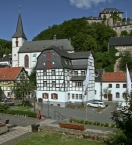
Blankenheim ist eine Gemeinde in Nordrhein-Westfalen (Deutschland) im Kreis Euskirchen. Die Hauptattraktion des staatlich anerkannten Erholungsortes ist die Ahrquelle in einem Kellergewölbe eines Fachwerkhauses aus dem Jahre 1726. Der gut 8.000 Einwohner zählende Ort verfügt über einen historischen Ortskern mit einer Anzahl bemerkenswerter Sehenswürdigkeiten. Erholungsanlagen des Ortes gruppieren sich um den Schloßweiher. Inmitten des historischen Ortskerns befindet sich das Eifelmuseum Blankenheim ![]() .
.
Kultur und Sehenswürdigkeiten
Museen
- Blankenheimer Karnevalsmuseum

- Eifelmuseum Blankenheim , ein Regionalmuseum für Naturkunde und Kulturgeschichte der Nord/West-Eifel.
- Naturkundliche Ausstellung
Bauwerke
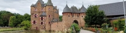
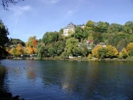
Oberhalb des Ortes befindet sich die Burg Blankenheim ![]() aus dem 12. Jahrhundert. Sie wird heute als Jugendherberge genutzt. Im Zuge der Regierungsübernahme der Grafen von Manderscheid auf Burg Blankenheim im Jahre 1468 wurden bauliche Veränderungen vorgenommen. Graf Dietrich III. ließ eine Fernwasserversorgung zur Burg bauen, die unter dem „Tiergarten“-Berg in einem Tunnel geführt werden musste, um Gefälle zu behalten. Der Tunnel ist der einzig bekannte des späten Mittelalters in ganz Europa. Der wuchtige Bau der Burg beherrscht das Bild von Blankenheim.
aus dem 12. Jahrhundert. Sie wird heute als Jugendherberge genutzt. Im Zuge der Regierungsübernahme der Grafen von Manderscheid auf Burg Blankenheim im Jahre 1468 wurden bauliche Veränderungen vorgenommen. Graf Dietrich III. ließ eine Fernwasserversorgung zur Burg bauen, die unter dem „Tiergarten“-Berg in einem Tunnel geführt werden musste, um Gefälle zu behalten. Der Tunnel ist der einzig bekannte des späten Mittelalters in ganz Europa. Der wuchtige Bau der Burg beherrscht das Bild von Blankenheim.
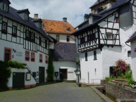
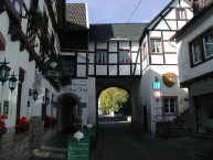
Der mittelalterliche Ortskern bietet Reste der Befestigung (Georgstor von 1670, Hirtenturm von 1404), einige Fachwerkbauten sowie die Pfarrkirche St. Mariä Himmelfahrt ![]() (fertiggestellt 1505). Sehenswert ist auch die denkmalgeschützte Kreuzkapelle
(fertiggestellt 1505). Sehenswert ist auch die denkmalgeschützte Kreuzkapelle ![]() .
.
Die in der Ortsmitte gelegene Quelle der Ahr ![]() wurde im Keller eines Fachwerkhauses gefasst.
wurde im Keller eines Fachwerkhauses gefasst.
Information about copyright | |
|---|---|
Rights characteristic / license | by-sa: CREATIVE COMMONS Attribution-ShareAlike |
Link to the description of the license | |
Input taken over from: |
Seite „Blankenheim (Ahr)“. In: Wikipedia, Die freie Enzyklopädie. Bearbeitungsstand: 5. November 2013, 18:13 UTC. URL: http://de.wikipedia.org/w/index.php?title=Blankenheim_(Ahr)&oldid=124172684 (Abgerufen: 14. Januar 2014, 14:31 UTC) |
taken over / edited on | 14 Jan 2014
|
taken over / edited by |
|
2 km
3,4 km
480 m
![]()