Gera Cycle Route
Actions
![]()
Please wait - map data are loading
Added on 25 Apr 2012,
last edited by biroto-Redaktion on 16 Nov 2020
Actions
Cycle route metrics
Total distance in km
75
Information about rights to the gps-track data | |
|---|---|
Rights owner | OpenStreetMap and Contributors + biroto-Redaktion (biroto.eu) |
Rights characteristic / license | Contains information from OpenStreetMap, which is made available here under the Open Database License(ODbL) |
Link to the description of the license | |
GPX file taken from | |
GPX file uploaded | by biroto-Redaktion on 16 Nov 2020
|
Track points in total
1.375
Track points per km (avg)
18
Start/endpoint
Start location
Gehlberg, Thüringen, DE (916 m NHN)
End location
Gebesee, Thüringen, DE (155 m NHN)
Signposting
|
Sources of information
Bücher und Karten:
- Esterbauer bikeline Ilmtal-Radweg Gera-Radweg Laura-Radweg: 245 km,140 Seiten, 1:50,000, wetterfest
Beds4Cyclists, worth visiting and infrastructure
Name and address
Latitude / Longitude
Phone
Fax
Mobile
Type of accommodation
Rating for cyclists
Route km
Dist. to route
Elevation
0 km
3,3 km
567 m
Hours of opening
Monday to Friday from 9:00 to 16:00
8 km
2,3 km
679 m
30 km
0,1 km
284 m
39 km
0,1 km
227 m
Information about copyright | |
|---|---|
Rights owner | |
Rights characteristic / license | by-sa: CREATIVE COMMONS Attribution-ShareAlike |
Link to the description of the license | |
Image taken over from | |
Image has been uploaded | by biroto-Redaktion on 16 Mar 2013
|
Information about copyright | |
|---|---|
Rights owner | |
Rights characteristic / license | by-sa: CREATIVE COMMONS Attribution-ShareAlike |
Link to the description of the license | |
Image taken over from | |
Image has been uploaded | by biroto-Redaktion on 16 Mar 2013
|
Information about copyright | |
|---|---|
Rights owner | |
Rights characteristic / license | by-sa: CREATIVE COMMONS Attribution-ShareAlike |
Link to the description of the license | |
Image taken over from | commons.wikimedia.org/wiki/File:Schloss_molsdorf_erfurt_okt04_11k.jpg |
Image has been uploaded | by biroto-Redaktion on 16 Mar 2013
|
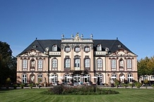
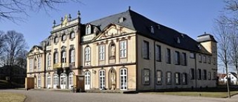
Schloss Molsdorf ist ein Barockschloss in Molsdorf , einem Ortsteil von Erfurt
und wird als eines der schönsten Barock-Schlösser Thüringens angesehen. Das Schloss gehört heute der Stiftung Thüringer Schlösser und Gärten. In einigen Räumen des Erdgeschosses befindet sich ein Speiserestaurant. Außerdem beherbergt das Museum eine Gemäldesammlung des Malers Otto Knöpfer.
Ab 1990 wurde das Schloss umfassend saniert und dann zur Besichtigung freigegeben.
Information about copyright | |
|---|---|
Rights characteristic / license | by-sa: CREATIVE COMMONS Attribution-ShareAlike |
Link to the description of the license | |
Input taken over from: |
Seite „Schloss Molsdorf“. In: Wikipedia, Die freie Enzyklopädie. Bearbeitungsstand: 22. Februar 2013, 16:39 UTC. URL: http://de.wikipedia.org/w/index.php?title=Schloss_Molsdorf&oldid=114547078 (Abgerufen: 16. März 2013, 15:39 UTC) |
taken over / edited on | 16 Mar 2013 - 18 Sep 2014
|
taken over / edited by |
|
51 km
0,3 km
191 m
![]()


