
German Limes Cycle Route
Actions
![]()
Please wait - map data are loading
Added on 02 Jan 2012,
last edited by biroto-Redaktion on 16 Apr 2024
Actions
Cycle route metrics
Total distance in km
1.245
Information about rights to the gps-track data | |
|---|---|
Rights owner | OpenStreetMap and Contributors + biroto-Redaktion (biroto.eu) |
Rights characteristic / license | Contains information from OpenStreetMap, which is made available here under the Open Database License(ODbL) |
Link to the description of the license | |
GPX file taken from | |
GPX file uploaded | by biroto-Redaktion on 16 Apr 2024
|
Track points in total
20.250
Track points per km (avg)
16
Start/endpoint
Start location
Kleve, Nordrhein-Westfalen, DE (13 m NHN)
End location
Passau, Bayern, DE (296 m NHN)
Signposting
|
|

Sources of information
Portale:
- offizielle Site der Deutschen Limes-Straße
Bücher/Karten:
- Esterbauer bikeline: Radtourenbuch Limes-Radweg Auf der UNESCO Weltkulturerbestätte Obrgermanisch-Rätischer Limes vom Rhein an die Donau, 816 km, 1:75.000, wetterfest, reißfest
Travel reports about cycle tours
19 Aug 2013
98 km
A stage of the tour »River Main Cycle Route and Middle Rhine Valley« of user ThimbleU
Beds4Cyclists, worth visiting and infrastructure
Name and address
Latitude / Longitude
Phone
Fax
Mobile
Type of accommodation
Rating for cyclists
Route km
Dist. to route
Elevation
4 km
3,1 km
24 m
7 km
2,4 km
10 m
DE-47533 Kleve-Rindern
Boardinghouse / guest house
10 km
3,9 km
33 m
Information about copyright | |
|---|---|
Rights owner | |
Rights characteristic / license | by-sa: CREATIVE COMMONS Attribution-ShareAlike |
Link to the description of the license | |
Image taken over from | |
Image has been uploaded | by biroto-Redaktion on 10 Jan 2013
|
Information about copyright | |
|---|---|
Rights owner | |
Rights characteristic / license | by-sa: CREATIVE COMMONS Attribution-ShareAlike |
Link to the description of the license | |
Image taken over from | |
Image has been uploaded | by biroto-Redaktion on 10 Jan 2013
|
Information about copyright | |
|---|---|
Rights owner | |
Rights characteristic / license | by-sa: CREATIVE COMMONS Attribution-ShareAlike |
Link to the description of the license | |
Image taken over from | |
Image has been uploaded | by biroto-Redaktion on 10 Jan 2013
|
Information about copyright | |
|---|---|
Rights owner | |
Rights characteristic / license | by-sa: CREATIVE COMMONS Attribution-ShareAlike |
Link to the description of the license | |
Image taken over from | |
Image has been uploaded | by biroto-Redaktion on 07 Sep 2016
|
Kleve is in the Lower Rhine region of Western Germany.
Understand
Kleve (formerly spelled Cleves) used to be the capital of an eponymous County, and later Duchy, that existed from c. 1020 until 1795. From 1609 on, it was ruled in personal union by the Prince-Electors of Brandenburg who later became the Kings of Prussia. During the 17th century, it was one of three residences of Brandenburg-Prussia (besides Berlin and Königsberg). After being occupied by France for 20 years, it was annexed to the Prussian Rhine Province in 1815. Thanks to its mineral springs, Bad Cleve was a popular spa town from the mid-18th century until the spring dried up in 1914. Nowadays, the town of some 50,000 inhabitants is a county seat and member of the Dutch-German Euregio Rhine-Waal.
See
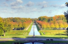
- Kleve stands out with its extensive parks and gardens, dating back to the Baroque era. They were created during the governorship of Johann Moritz of Nassau-Siegen by the Dutch landscape gardener Jacob van Campen, starting in 1647. At the era, they enjoyed Europe-wide fame and were used as a model for other famous parks, including the gardens of Potsdam. The most original part is the ⊙Neuer Tiergarten ("new game garden"). for which an artificial hill, called Springenberg, was raised. On the hilltop is an obelisk, on the hillside a decorative amphitheatre, and at its foot there is another park marked by a long body of water. The neighbouring ⊙Forstgarten ("forest garden"). is an arboretum with several different tree species. The grounds are surrounded by a narrow moat, designed to prevent cattle or trespassers from entering without disrupting the view (as a wall or fence would have done). Finally, there is the Alter Tiergarten with Prince Johann Moritz's sepulchre (on Uedemer Straße near Bedburg-Hau, 3.5 km southeast of downtown Kleve), consisting of a cast-iron tumba and exedra, which is however empty as the Prince was eventually buried in Siegen rather than in Kleve.
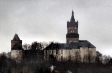
- ⊙Schwanenburg. Kleve's main landmark was begun in the 11th century as a spur castle, but later transformed into a more comfortable and representative Baroque residence. Its most characteristic item is a weather vane in form of a swan (heraldic animal and crest of the Dukes of Cleves), hence the name. It houses the Kleve district court, a geological museum, showing mineralogical and paleontologic exhibits from the Lower Rhine area, as well as a photo exposition.
- ⊙Museum Kurhaus Kleve. Art museum with collections of works by Rhineland artists Ewald Mataré and Joseph Beuys, medieval, Renaissance and Baroque works, as well as pieces of contemporary art, graphics and applied arts.
- ⊙B.C. Koekkoek-Haus. Collection of paintings by Barend Cornelis Koekkoek, who used to live in this house with his family, as well as other Dutch romantic artists of his circle.
- ⊙Unterstadtkirche (St Mary of the Immaculate Conception). Very modest Gothic hall church without a steeple, that used to be the monastic church of a Minorites monastery.
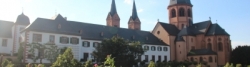
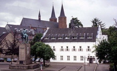
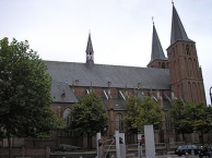
- ⊙Stiftskirche (Church of the Assumption of Mary). Kleve's Gothic, three-aisled main parish church.
- ⊙Kleine Evangelische Kirche (Trinity Church). Small Lutheran church in the predominantly Catholic town, consecrated in 1621.
Information about copyright | |
|---|---|
Rights characteristic / license | by-sa: CREATIVE COMMONS Attribution-ShareAlike |
Link to the description of the license | |
Input taken over from: |
Wikivoyage contributors, 'Kleve', Wikivoyage, The FREE worldwide travel guide that anyone can edit, 17 August 2016, 05:09 UTC, https://en.wikivoyage.org/w/index.php?title=Kleve&oldid=3035336 [accessed 7 September 2016] |
taken over / edited on | 07 Sep 2016 - 23 Dec 2020
|
taken over / edited by |
|
10 km
3,8 km
10 m
10 km
4,1 km
40 m
![]()