
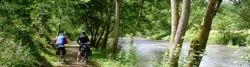
Kyll Cycle Route
Actions
![]()
Please wait - map data are loading
Added on 26 Apr 2012,
last edited by biroto-Redaktion on 16 Nov 2020
Actions
Cycle route metrics
Total distance in km
122
Information about rights to the gps-track data | |
|---|---|
Rights owner | OpenStreetMap and Contributors + biroto-Redaktion (biroto.eu) |
Rights characteristic / license | Contains information from OpenStreetMap, which is made available here under the Open Database License(ODbL) |
Link to the description of the license | |
GPX file taken from | |
GPX file uploaded | by biroto-Redaktion on 16 Nov 2020
|
Track points in total
2.347
Track points per km (avg)
19
Start/endpoint
Start location
Hellenthal, Nordrhein-Westfalen, DE (609 m NHN)
End location
Trier, Rheinland-Pfalz, DE (132 m NHN)
Signposting
|

Sources of information
Travel reports about cycle tours
02 Jul 2007
111 km
A stage of the tour »Euskirchen - Kyll - Moselle - Lahn - Siegen« of user ThimbleU
Beds4Cyclists, worth visiting and infrastructure
Name and address
Latitude / Longitude
Phone
Fax
Mobile
Type of accommodation
Rating for cyclists
Route km
Dist. to route
Elevation
0 km
2,1 km
676 m
12 km
0,4 km
535 m
16 km
0,3 km
450 m
20 km
0,1 km
432 m
Information about copyright | |
|---|---|
Rights owner | |
Rights characteristic / license | by-sa: CREATIVE COMMONS Attribution-ShareAlike |
Link to the description of the license | |
Image has been uploaded | by InduKult on 06 Dec 2015
|
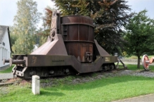
Der Bahnhof Jünkerath ist Ausgangspunkt für den Kyall-Radweg abwärts nach Trier, den Radweg Vennquerbahn. Außerdem lässt sich die Strecke nutzen, um die Steigung zwischen Kylltal und Urft bis zum Bf. Blankenheim Wald zu überbrücken. Züge nach Euskirchen-Köln bzw. Bitburg-Trier.
Information about copyright | |
|---|---|
Rights characteristic / license | by-sa: CREATIVE COMMONS Attribution-ShareAlike |
Link to the description of the license | |
taken over / edited on | 06 Dec 2015
|
taken over / edited by |
|
25 km
0,0 km
404 m
![]()