
Lenne Cycle Route
Actions
![]()
Please wait - map data are loading
Added on 29 May 2011,
last edited by biroto-Redaktion on 22 Nov 2020
Actions
Cycle route metrics
Total distance in km
144
Information about rights to the gps-track data | |
|---|---|
Rights owner | OpenStreetMap and Contributors + biroto-Redaktion (biroto.eu) |
Rights characteristic / license | Contains information from OpenStreetMap, which is made available here under the Open Database License(ODbL) |
Link to the description of the license | |
GPX file taken from | |
GPX file uploaded | by biroto-Redaktion on 22 Nov 2020
|
Track points in total
2.804
Track points per km (avg)
19
Start/endpoint
Start location
Winterberg, Nordrhein-Westfalen, DE (657 m NHN)
End location
Wetter (Ruhr), Nordrhein-Westfalen, DE (92 m NHN)
Signposting
|

Sources of information
Portale:
- Portal der Lenneroute
Bücher/Karten:
- Esterbauer bikeline: Flüsse und Bahntrassen Bergisches Land
Siegtal, Lenne, Ruhr-Sieg & Panorama-Radwege, 1:50.000. 608 km, wetterfest/reißfest
Travel reports about cycle tours
29 Jun 2022
101 km
A stage of the tour »West Hessian mountain country - Lenne - Ruhr« of user ThimbleU
30 Jun 2022
75 km
A stage of the tour »West Hessian mountain country - Lenne - Ruhr« of user ThimbleU
Beds4Cyclists, worth visiting and infrastructure
Name and address
Latitude / Longitude
Phone
Fax
Mobile
Type of accommodation
Rating for cyclists
Route km
Dist. to route
Elevation
0 km
0,4 km
653 m
0 km
2,6 km
664 m
Information about copyright | |
|---|---|
Rights owner | |
Rights characteristic / license | by-sa: CREATIVE COMMONS Attribution-ShareAlike |
Link to the description of the license | |
Image taken over from | |
Image has been uploaded | by biroto-Redaktion on 17 Apr 2012
|
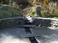
Die Ruhrquelle ist der Ursprung der Ruhr ![]() , eines 219 Kilometer langen Nebenflusses des Rheins.
, eines 219 Kilometer langen Nebenflusses des Rheins.
Sie befindet sich im nordöstlichen Teil des Rothaargebirges ![]() etwa drei Kilometer nordöstlich von Winterberg
etwa drei Kilometer nordöstlich von Winterberg ![]() am Nordosthang des 695,7 Meter hohen Ruhrkopfs
am Nordosthang des 695,7 Meter hohen Ruhrkopfs ![]() . Bis zur Bergkuppe sind es rund 330 Meter in der Luftlinie. Der Ort, der der Ruhrquelle am nächsten liegt, ist Grönebach in rund zwei Kilometer Entfernung.
. Bis zur Bergkuppe sind es rund 330 Meter in der Luftlinie. Der Ort, der der Ruhrquelle am nächsten liegt, ist Grönebach in rund zwei Kilometer Entfernung.
Die Ruhr entspringt einem nur wenige Quadratmeter großen, sumpfig-morastigen Gebiet im Wald, das unter Naturschutz steht. Etwa 20 Meter unterhalb der Quelle befindet sich ein im Jahre 1980 restauriertes Rondell (666,5 m ü. NN), an dem ein Gedenkstein errichtet wurde. Der Stein erinnert sowohl an ihre erstmalige steinerne Einfassung von 1849 als auch an das Hundertjahresjubiläum von 1949.
Die Ruhrquelle hat im Durchschnitt eine Ergiebigkeit von 2500 Litern pro Stunde.
Information about copyright | |
|---|---|
Rights characteristic / license | by-sa: CREATIVE COMMONS Attribution-ShareAlike |
Link to the description of the license | |
Input taken over from: |
Seite „Ruhrquelle“. In: Wikipedia, Die freie Enzyklopädie. Bearbeitungsstand: 28. Januar 2012, 13:50 UTC. URL: http://de.wikipedia.org/w/index.php?title=Ruhrquelle&oldid=98943966 (Abgerufen: 17. April 2012, 10:14 UTC) |
taken over / edited on | 17 Apr 2012
|
taken over / edited by |
|
0 km
0,2 km
668 m
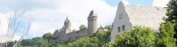
Winterberg is a town in the Hochsauerland ![]() district of North Rhine-Westphalia, Germany and a major winter sport resort of the Wintersport Arena
district of North Rhine-Westphalia, Germany and a major winter sport resort of the Wintersport Arena ![]() Sauerland.
Sauerland.
Among the sights of Winterberg are in addition to the St. James Church many old half-timbered houses in the old town. The St. George's ski-jump attracts many visitors. A prime example of successful church architecture is the Evangelical Church in Winterberg.
Information about copyright | |
|---|---|
Rights characteristic / license | by-sa: CREATIVE COMMONS Attribution-ShareAlike |
Link to the description of the license | |
Input taken over from: |
Seite „Winterberg“. In: Wikipedia, Die freie Enzyklopädie. Bearbeitungsstand: 10. April 2012, 16:34 UTC. URL: http://de.wikipedia.org/w/index.php?title=Winterberg&oldid=101897318 |
taken over / edited on | 16 Apr 2012 - 28 Jun 2022
|
taken over / edited by |
|
0 km
0,4 km
660 m
0 km
0,4 km
660 m
Hours of opening
Montag - Freitag | 10:00 - 17:00 Uhr | |
Samstag | 10:00 - 14:00 Uhr | |
Sonntag | 10:00 - 13:00 Uhr |
![]()