
Paartal Cycle Route
Actions
![]()
Please wait - map data are loading
Added on 30 Apr 2012,
last edited by biroto-Redaktion on 18 Nov 2020
Actions
Cycle route metrics
Total distance in km
116
Information about rights to the gps-track data | |
|---|---|
Rights owner | OpenStreetMap and Contributors + biroto-Redaktion (biroto.eu) |
Rights characteristic / license | Contains information from OpenStreetMap, which is made available here under the Open Database License(ODbL) |
Link to the description of the license | |
GPX file taken from | |
GPX file uploaded | by biroto-Redaktion on 18 Nov 2020
|
Track points in total
2.078
Track points per km (avg)
18
Start/endpoint
Start location
Eresing, Bayern, DE (573 m NHN)
End location
Großmehring, Bayern, DE (364 m NHN)
Beds4Cyclists, worth visiting and infrastructure
Name and address
Latitude / Longitude
Phone
Fax
Mobile
Type of accommodation
Rating for cyclists
Route km
Dist. to route
Elevation
38 km
2,4 km
516 m
Information about copyright | |
|---|---|
Rights owner | |
Rights characteristic / license | by: CREATIVE COMMONS Attribution |
Link to the description of the license | |
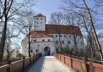
Image taken over from | https://commons.wikimedia.org/wiki/File:Zugang_zu_Schloss_Friedberg_nach_Renovierung_2018.jpg |
Image has been uploaded | by biroto-Redaktion on 06 Mar 2021
|
Information about copyright | |
|---|---|
Rights owner | https://commons.wikimedia.org/w/index.php?title=User:Henri97 |
Rights characteristic / license | by-sa: CREATIVE COMMONS Attribution-ShareAlike |
Link to the description of the license | |
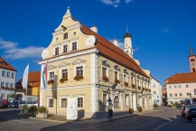
Image taken over from | https://commons.wikimedia.org/wiki/File:Rathaus_Friedberg_(Bayern).jpg |
Image has been uploaded | by biroto-Redaktion on 06 Mar 2021
|
Information about copyright | |
|---|---|
Rights owner | |
Rights characteristic / license | by-sa: CREATIVE COMMONS Attribution-ShareAlike |
Link to the description of the license | |
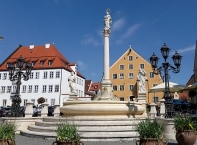
Image taken over from | https://commons.wikimedia.org/wiki/File:Marienbrunnen_Friedberg_(Bayern).jpg |
Image has been uploaded | by biroto-Redaktion on 06 Mar 2021
|
Friedberg (Bayern) ist eine Stadt in Schwaben (Regierungsbezirk) in unmittelbarer Nähe zu Augsburg ![]() .
.
Hintergrund
Urkundlich das erste Mal erwähnt wurde das Städtchen in einem Schutzbrief des Staufers Konradin zusammen mit dem Herzog Ludwig II. an die Bürger der Stadt Augsburg des Jahres 1264: In ihm ist die Errichtung einer Burg Fridberch angekündigt, die fortan als Grenz- und Zollsicherung des Herzogtums Bayern gegenüber Schwaben und der freien Reichsstadt Augsburg dienen sollte. Diese Funktion bedeutete bald Ärger mit den mächtigen Augsburgern, die erstmals im Jahre 1396 die Stadt niederbrannten. Ihre Lage brachte der Stadt oftmals Probleme ein, da die nicht seltenen kriegerischen Auseinandersetzungen zwischen Bayern und Augsburg bzw. Schwaben meist auf dem Rücken der Stadt ausgetragen wurden. Im Jahr 1485 wird in Friedberg Balthasar Hubmaier, eine führende Täuferpersönlichkeit der Reformationszeit, geboren.
Ein Aufschwung kam erst, nachdem Herzogin Christine von Lothringen die Friedberger Burg 1568 zu ihrem Witwensitz erkor, was die Stadt in einen Mittelpunkt des bayerischen Hoflebens verwandelte. Im folgenden Jahrhundert jedoch wurde dieser blühenden Zeit ein abruptes Ende bereitet: 1599 wütete die Pest furchtbar in der Stadt, und im Dreißigjährigen Krieg wurde die Stadt gleich zweimal von den Schweden völlig vernichtet. Bis auf die Burg und die Stadtmauer ist heute kein Gebäude älter als das Rathaus, das kurz nach Kriegsende erbaut wurde. In den folgenden Jahren blühte die Friedberger Wirtschaft wieder mit Macht auf, als die zahlreich in Erscheinung getretenen Uhrmacher die Stadt wieder zu einem Mittelpunkt machten: Friedberg war damals vielen Uhrliebhabern ein Begriff, und Friedberger Uhren sind heute noch begehrt. 1753 wurde die Wallfahrtskirche Herrgottsruh ![]() errichtet, die mit zu den schönsten Kirchen des bayerischen Rokoko gehört. Von 1754 bis 1768 wurde vom bayerischen Kurfürsten Max III. Joseph im Friedberger Schloss eine Fayencemanufaktur betrieben. Im 19. Jahrhundert war Friedberg vor allem Nutznießer der drängenden Wohnungsnot im prosperierenden Augsburg.
errichtet, die mit zu den schönsten Kirchen des bayerischen Rokoko gehört. Von 1754 bis 1768 wurde vom bayerischen Kurfürsten Max III. Joseph im Friedberger Schloss eine Fayencemanufaktur betrieben. Im 19. Jahrhundert war Friedberg vor allem Nutznießer der drängenden Wohnungsnot im prosperierenden Augsburg.
Die beiden Weltkriege überstand die Stadt ohne größeren Schaden.
Sehenswürdigkeiten
Museen
- ⊙Schlossmuseum Friedberg
 mit vielen bestens erhaltenen Friedberger Uhren
Bauwerke
- ⊙Schloss Friedberg (1257 erbaut, heutiges Gebäude größtenteils aus dem 16. Jahrhundert)
- ⊙Rathaus (um 1680), erbaut von einem Schüler des Elias Holl
- Pfarrkirche ⊙St. Jakob (1871–1872)
- ⊙Wallfahrtskirche „Unseres Herrn Ruhe“ (1731–1753), einer der schönsten Rokokobauten in Bayern
- ⊙Marienbrunnen mit Pestsäule auf dem Marienplatz (um 1600)
- ⊙Kirche St. Stephan , (1698)
- Kirche ⊙St. Afra im Felde (1710). An dieser Stelle soll die Heilige Afra den Märtyrertod gestorben sein.
- ⊙Wallfahrtskapelle Maria Alber (1686)
- ⊙Historische Stadtmauer (1409)
- ⊙Pallottikirche (1955 erbaut, 2013 umgestaltet) mit einer Gedenktafel für den Pazifisten und Pallottinerpater Franz Reinisch, der den Eid auf Hitler verweigerte und deswegen 1942 in Brandenburg-Görden ermordet wurde
Information about copyright | |
|---|---|
Rights characteristic / license | by-sa: CREATIVE COMMONS Attribution-ShareAlike |
Link to the description of the license | |
Input taken over from: |
|
taken over / edited on | 06 Mar 2021 - 10 Mar 2021
|
taken over / edited by |
|
83 km
0,9 km
405 m