
Panorama Cycle Route Niederbergbahn
Actions
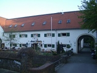
![]()
Please wait - map data are loading
Added on 21 Nov 2013,
last edited by biroto-Redaktion on 20 Jun 2021
Actions
Cycle route metrics
Total distance in km
41
Information about rights to the gps-track data | |
|---|---|
Rights owner | OpenStreetMap and Contributors + biroto-Redaktion (biroto.eu) |
Rights characteristic / license | Contains information from OpenStreetMap, which is made available here under the Open Database License(ODbL) |
Link to the description of the license | |
GPX file taken from | |
GPX file uploaded | by biroto-Redaktion on 24 Nov 2020
|
Track points in total
674
Track points per km (avg)
16
Start/endpoint
Start location
Haan, Nordrhein-Westfalen, DE (182 m NHN)
End location
Essen, Nordrhein-Westfalen, DE (67 m NHN)
Character
Den PanoramaRadweg Niederbergbahn erreichen Sie in Essen-Kettwig vom RuhrtalRadweg aus über die Ruhrbrücke.
Er führt auf rund 40 Kilometern von Heiligenhaus über Wülfrath und Velbert bis nach Haan durch das neanderland / den Kreis Mettmann. Trotz der hügeligen Landschaft lässt es sich auf dieser ehemaligen Bahntrasse entspannt radeln.
Zahlreiche Brücken und Viadukte bieten nicht nur beeindruckende Aussichten, sondern sind auch eindrucksvolle Zeugnisse der Ingenieurskunst der letzten Jahre. Sehenswert ist die deutschlandweit einzigartige Waggonbrücke in Heiligenhaus. Abstecher in die Umgebung, wie zum Beispiel zum Mariendom in Velbert, dem Denkmalbereich Abtsküche in Heiligenhaus, dem Zeittunnel in Wülfrath, dem historischen Dorf Gruiten und dem Neanderthal Museum in Mettmann, sind lohnenswert.
Information about copyright | |
|---|---|
Rights characteristic / license | by-sa: CREATIVE COMMONS Attribution-ShareAlike |
Link to the description of the license | |
Input taken over from: |
Rechteinhaber: Bergische Entwicklungsagentur, Erlaubnis erhalten am 27.11.2013. |
taken over / edited on | 29 Nov 2013
|
taken over / edited by |
|
Signposting
Der Radweg ist mit Behelfsbeschilderng ausgezeichnet und wird bis Ende 2014 komplett neu beschildert. |
|

Sources of information
Portale:
- Offizielles Portal Panorama-Radweg Niederbergbahn
- Portal der Panorama-Radwege
- Panorama-Radwegeauf "Die Bergischen Drei"
Bücher:
- Esterbauer bikeline: Mit dem Fahrrad über Panoramawege im Bergischen Land. Die 11 schönsten Höhenwege zwischen Wupper und Sieg
- ADFC-Radausflugsführer Bergische Bahntrassen 1:50.000 praktische Spiralbindung, reiß- und wetterfest, GPS-Tracks Download: Mit Bergischem Panorama-Radweg, Niederbergbahn und Balkantrasse
- Esterbauer bikeline: Flüsse und Bahntrassen Bergisches Land
Siegtal, Lenne, Ruhr-Sieg & Panorama-Radwege, 1:50.000. 608 km, wetterfest/reißfest
Connecting cycle path
- in Kettwig
- bei Aprath Kaiser-Route
- bei Gräfrath Bergischer Panorama-Radweg
Beds4Cyclists, worth visiting and infrastructure
Name and address
Latitude / Longitude
Phone
Fax
Mobile
Type of accommodation
Rating for cyclists
Route km
Dist. to route
Elevation
1 km
2,0 km
205 m
Information about copyright | |
|---|---|
Rights owner | |
Rights characteristic / license | cc0: Public Domain no Rights reserved |
Link to the description of the license | |
Image taken over from | |
Image has been uploaded | by biroto-Redaktion on 17 Apr 2012
|
Information about copyright | |
|---|---|
Rights owner | |
Rights characteristic / license | cc0: Public Domain no Rights reserved |
Link to the description of the license | |
Image taken over from | commons.wikimedia.org/wiki/File:Solingen_Graefrath_2006_08_09_0093.jpg |
Image has been uploaded | by biroto-Redaktion on 17 Apr 2012
|
Information about copyright | |
|---|---|
Rights owner | |
Rights characteristic / license | cc0: Public Domain no Rights reserved |
Link to the description of the license | |
Image taken over from | commons.wikimedia.org/wiki/File:Solingen_Graefrath_2006_08_09_0080.jpg |
Image has been uploaded | by biroto-Redaktion on 17 Apr 2012
|
Information about copyright | |
|---|---|
Rights owner | |
Rights characteristic / license | by-sa: CREATIVE COMMONS Attribution-ShareAlike |
Link to the description of the license | |
Image taken over from | commons.wikimedia.org/wiki/File:Deutsches-klingenmuseum-20010502.jpg |
Image has been uploaded | by biroto-Redaktion on 17 Apr 2012
|
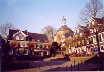
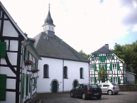
Gräfrath ist ein Stadtteil bzw. Stadtbezirk von Solingen ![]() . Gräfrath liegt im Norden der Stadt Solingen und grenzt an die Städte Haan
. Gräfrath liegt im Norden der Stadt Solingen und grenzt an die Städte Haan ![]() und Wuppertal
und Wuppertal ![]() .
.
Erstmals 1135 als villa Greverode (Rodung eines Grafen) erwähnt, wurde Gräfrath 1402 durch Herzog Wilhelm I. von Jülich-Berg zur Freiheit erhoben. Die Stadtrechte erhielt Gräfrath 1865.
Sehenswürdigkeiten:
- Historischer Ortskern mit Marktplatz
- Ehemalige Kloster-
 und heutige Pfarrkirche St. Mariä Himmelfahrt
 - Deutsches Klingenmuseum, im ehemaligen Kloster in der Nähe des Marktplatzes (Ausstellung über Schneidwerkzeuge, Messer und Blankwaffen)
- Museum Baden im ehemaligen Gräfrather Rathaus, erbaut 1907–1908 durch den Architekten Arno Eugen Fritsche, bis 1929 als Rathaus und 1934–1989 als Deutsches Klingenmuseum genutzt
- Tierpark „Fauna“
Information about copyright | |
|---|---|
Rights characteristic / license | by-sa: CREATIVE COMMONS Attribution-ShareAlike |
Link to the description of the license | |
Input taken over from: |
Seite „Gräfrath“. In: Wikipedia, Die freie Enzyklopädie. Bearbeitungsstand: 25. März 2012, 11:36 UTC. URL: http://de.wikipedia.org/w/index.php?title=Gr%C3%A4frath&oldid=101280200 (Abgerufen: 17. April 2012, 11:12 UTC) |
taken over / edited on | 17 Apr 2012 - 21 Aug 2015
|
taken over / edited by |
|
4 km
1,4 km
117 m
Information about copyright | |
|---|---|
Rights owner | |
Rights characteristic / license | cc0: Public Domain no Rights reserved |
Link to the description of the license | |
Image taken over from | https://commons.wikimedia.org/wiki/File:Gruiten_EvKirche.jpg |
Image has been uploaded | by biroto-Redaktion on 21 Nov 2013
|
Information about copyright | |
|---|---|
Rights owner | |
Rights characteristic / license | by-sa: CREATIVE COMMONS Attribution-ShareAlike |
Link to the description of the license | |
Image taken over from | https://commons.wikimedia.org/wiki/File:Gruiten_Dorf_-_Weberkontor_Schwanen.jpg |
Image has been uploaded | by biroto-Redaktion on 21 Nov 2013
|
Information about copyright | |
|---|---|
Rights owner | |
Rights characteristic / license | by-sa: CREATIVE COMMONS Attribution-ShareAlike |
Link to the description of the license | |
Image taken over from | https://commons.wikimedia.org/wiki/File:Gruiten_Dorf_-_Haus_Am_Quall.jpg |
Image has been uploaded | by biroto-Redaktion on 21 Nov 2013
|
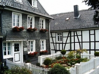
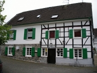
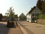
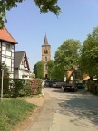
Gruiten (gesprochen: Grüten) ist ein Stadtteil der Stadt Haan ![]() im Kreis Mettmann im Land Nordrhein-Westfalen.
im Kreis Mettmann im Land Nordrhein-Westfalen.
Gruiten besteht aus Gruiten-Dorf und Gruiten, wo das neue Ortszentrum, das ehemalige Rathaus und der Bahnhof liegen. Durch Gruiten-Dorf fließt die Düssel ![]() , die hier Zufluss durch die Kleine Düssel
, die hier Zufluss durch die Kleine Düssel ![]() erhält.
erhält.
Sehenswürdigkeiten
Der Ortsteil Gruiten-Dorf mit seinen gut erhaltenen Fachwerkhäusern stellt die größte intakte historische Siedlung auf Haaner Stadtgebiet dar. Auf dem Friedhof hat sich der romanische alte Kirchturm ![]() erhalten.
erhalten.
Ältestes Wohnhaus ist das „Haus am Quall“, von dem zumindest ein Gebäudetrakt auf das 14. Jahrhundert zurückdatiert werden kann. Es war ursprünglich Teil eines Hofes am Quall. 1978–1980 wurde es rekonstruiert und neu aufgebaut und heute für Feiern, Lehr- und Informationsveranstaltungen genutzt.
Die evangelisch-reformierte ![]() Kirche aus dem Jahr 1721 in dem Ensemble mit Predigthaus (1682) und Altem Pfarrhaus (1764) und der verbliebene Kirchturm der alten Wehrkirche auf dem katholischen Friedhof (Ende 12. Jahrhundert) lassen neben den traditionellen Wohnhäusern nacherleben, wie die bergischen Dörfer früher aussahen. Die römisch-katholische St.-Nikolaus-Kirche
Kirche aus dem Jahr 1721 in dem Ensemble mit Predigthaus (1682) und Altem Pfarrhaus (1764) und der verbliebene Kirchturm der alten Wehrkirche auf dem katholischen Friedhof (Ende 12. Jahrhundert) lassen neben den traditionellen Wohnhäusern nacherleben, wie die bergischen Dörfer früher aussahen. Die römisch-katholische St.-Nikolaus-Kirche ![]() stammt aus dem Jahr 1879.
stammt aus dem Jahr 1879.
Information about copyright | |
|---|---|
Rights characteristic / license | by-sa: CREATIVE COMMONS Attribution-ShareAlike |
Link to the description of the license | |
Input taken over from: |
Seite „Gruiten“. In: Wikipedia, Die freie Enzyklopädie. Bearbeitungsstand: 9. November 2013, 21:36 UTC. URL: http://de.wikipedia.org/w/index.php?title=Gruiten&oldid=124306429 (Abgerufen: 21. November 2013, 16:27 UTC) |
taken over / edited on | 21 Nov 2013
|
taken over / edited by |
|
6 km
0,1 km
135 m
Information about copyright | |
|---|---|
Rights owner | |
Rights characteristic / license | by-sa: CREATIVE COMMONS Attribution-ShareAlike |
Link to the description of the license | |
Image taken over from | |
Image has been uploaded | by biroto-Redaktion on 17 Apr 2012
|
Information about copyright | |
|---|---|
Rights owner | |
Rights characteristic / license | by-sa: CREATIVE COMMONS Attribution-ShareAlike |
Link to the description of the license | |
Image taken over from | commons.wikimedia.org/wiki/File:Mühle-und-Gut-zu-Schöller.jpg |
Image has been uploaded | by biroto-Redaktion on 17 Apr 2012
|
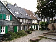
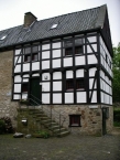
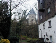
Das Rittergut Schöller (auch mit der Bezeichnung: Herrschaft Schöller und Herrlichkeit Schöller) ist ein abgegangener Adelssitz der Herren von Schöller im Wuppertaler ![]() Ortsteil Schöller
Ortsteil Schöller ![]() .
.
Der Bergfried und ein Teil der Burgmauer sind der letzte erhaltene Rest des ehemaligen Herrensitzes Schoeler, der aus dem späten 12. Jahrhundert stammt. Der Bergfried gehört heute zum Gut Schöller, besitzt die Hausanschrift Zur Düssel 2 und wird im Volksmund Schinderhannesturm genannt.
Information about copyright | |
|---|---|
Rights characteristic / license | by-sa: CREATIVE COMMONS Attribution-ShareAlike |
Link to the description of the license | |
Input taken over from: |
Seite „Rittergut Schöller“. In: Wikipedia, Die freie Enzyklopädie. Bearbeitungsstand: 17. Oktober 2011, 16:33 UTC. URL: http://de.wikipedia.org/w/index.php?title=Rittergut_Sch%C3%B6ller&oldid=94895514 (Abgerufen: 17. April 2012, 11:29 UTC) |
taken over / edited on | 17 Apr 2012
|
taken over / edited by |
|
7 km
2,6 km
Direkt am Radweg Korkenziehertrasse - Nordbahntrasse - Kohlenbahn mit einer Vielzahl von getakteten Regionalverkehrs-Relationen:
S9 Wuppertal - Essen - Bottrop - (Halterm)
S5/S8 Mönchengladbach - Wuppertal - Hagen - Dortmund
RE4 Aachen Mönchengladbach - Wuppertal - Hagen - Dortmund
R13 Venlo - Viersen - Düsseldorf - Wuppertal - Hagen - Hamm
RB48 Bon - Köln - Leverkusen - Solingen - Wuppertal
Information about copyright | |
|---|---|
Rights characteristic / license | by-sa: CREATIVE COMMONS Attribution-ShareAlike |
Link to the description of the license | |
taken over / edited on | 06 Dec 2015
|
taken over / edited by |
|
10 km
0,0 km
134 m
Information about copyright | |
|---|---|
Rights owner | |
Rights characteristic / license | by-sa: CREATIVE COMMONS Attribution-ShareAlike |
Link to the description of the license | |
Image taken over from | |
Image has been uploaded | by biroto-Redaktion on 17 Apr 2012
|
Information about copyright | |
|---|---|
Rights owner | |
Rights characteristic / license | by-sa: CREATIVE COMMONS Attribution-ShareAlike |
Link to the description of the license | |
Image taken over from | commons.wikimedia.org/wiki/File:Dorf_Düssel_-_Kirche_St._Maximin.jpg |
Image has been uploaded | by biroto-Redaktion on 17 Apr 2012
|
Information about copyright | |
|---|---|
Rights owner | |
Rights characteristic / license | by-sa: CREATIVE COMMONS Attribution-ShareAlike |
Link to the description of the license | |
Image taken over from | commons.wikimedia.org/wiki/File:Duessel_evangelische_kirche.jpg |
Image has been uploaded | by biroto-Redaktion on 17 Apr 2012
|
Information about copyright | |
|---|---|
Rights owner | |
Rights characteristic / license | by: CREATIVE COMMONS Attribution |
Link to the description of the license | |
Image taken over from | |
Image has been uploaded | by biroto-Redaktion on 17 Apr 2012
|
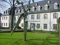
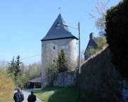
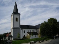
Düssel hat einen weitgehend erhaltenen historischen Ortskern. Sehenswert ist und insbesondere die Wasserburg Düssel ![]() mit zum größten Teil erhaltenen Burggraben sowie die aus dem 11. Jahrhundert stammende kath. Kirche St. Maximin
mit zum größten Teil erhaltenen Burggraben sowie die aus dem 11. Jahrhundert stammende kath. Kirche St. Maximin ![]() . Dominierende Gebäude des Ortskerns sind darüber hinaus die evangelische Kirche
. Dominierende Gebäude des Ortskerns sind darüber hinaus die evangelische Kirche ![]() und ein Sparkassengebäude am ehemaligen Marktplatz. Davor befindet sich eine lebensgroße Bronzeplastik des aus Düssel stammenden bergischen Heimatdichters Carl Schmachtenberg.
und ein Sparkassengebäude am ehemaligen Marktplatz. Davor befindet sich eine lebensgroße Bronzeplastik des aus Düssel stammenden bergischen Heimatdichters Carl Schmachtenberg.
Information about copyright | |
|---|---|
Rights characteristic / license | by-sa: CREATIVE COMMONS Attribution-ShareAlike |
Link to the description of the license | |
Input taken over from: |
Seite „Düssel (Wülfrath)“. In: Wikipedia, Die freie Enzyklopädie. Bearbeitungsstand: 13. September 2011, 20:25 UTC. URL: http://de.wikipedia.org/w/index.php?title=D%C3%BCssel_(W%C3%BClfrath)&oldid=93619230 (Abgerufen: 17. April 2012, 11:34 UTC) |
taken over / edited on | 17 Apr 2012 - 25 Nov 2013
|
taken over / edited by |
|
![]()