
Rennsteig Cycle Route
Actions
![]()
Please wait - map data are loading
Added on 03 May 2012,
on 21 Nov 2020
Actions
Cycle route metrics
Total distance in km
200
Information about rights to the gps-track data | |
|---|---|
Rights owner | OpenStreetMap and Contributors + biroto-Redaktion (biroto.eu) |
Rights characteristic / license | Contains information from OpenStreetMap, which is made available here under the Open Database License(ODbL) |
Link to the description of the license | |
GPX file taken from | |
GPX file uploaded | by biroto-Redaktion on 21 Nov 2020
|
Track points in total
3.736
Track points per km (avg)
19
Start/endpoint
Start location
Hörschel, Thüringen, DE (197 m NHN)
End location
Blankenstein, Thüringen, DE (422 m NHN)
Character
Der Rennsteig-Radwanderweg folgt auf 195 km Länge dem bereits seit dem Mittelalter existierenden Kurier- und Handelsweg Rennsteig. Der Radfernweg ist überwiegend sorgfältig geschottert, teilweise auch auf ruhigen Landstraßenabschnitten geführt. Auf dem Kamm des Thüringer Mittelgebirges ist der Radweg in großen Streckenabschnitten identisch mit dem gleichnamigen Wanderweg, weicht allerdings hier und da vom historischen Rennsteig ab, so dass starke Steigungen vermieden wurden. Start ist bei Hörschel westlich von Eisenach, Ziel ist in Blankenstein an der Saale.
Information about copyright | |
|---|---|
Rights characteristic / license | by-sa: CREATIVE COMMONS Attribution-ShareAlike |
Link to the description of the license | |
Input taken over from: |
Seite „Rennsteig-Radwanderweg“. In: Wikipedia, Die freie Enzyklopädie. Bearbeitungsstand: 4. April 2013, 12:27 UTC. URL: http://de.wikipedia.org/w/index.php?title=Rennsteig-Radwanderweg&oldid=117004331 (Abgerufen: 23. Juli 2013, 15:56 UTC) |
taken over / edited on | 23 Jul 2013 - 13 Mar 2014
|
taken over / edited by |
|
Signposting
|

Beds4Cyclists, worth visiting and infrastructure
Name and address
Latitude / Longitude
Phone
Fax
Mobile
Type of accommodation
Rating for cyclists
Route km
Dist. to route
Elevation
2 km
4,4 km
197 m
11 km
1,3 km
284 m
13 km
3,7 km
220 m
13 km
4,0 km
225 m
13 km
3,8 km
224 m
Eisenach is a town in Thuringia, Germany with 42,000 inhabitants. It is the main urban centre of western Thuringia and bordering north-eastern Hessian regions, situated near the former Inner German border. A major attraction is Wartburg ![]() castle, which has been a UNESCO world heritage site since 1999.
castle, which has been a UNESCO world heritage site since 1999.
Eisenach was an early capital of Thuringia in the 12th and 13th centuries. St. Elizabeth lived at the court of the Ludowingians here between 1211 and 1228. Later, Martin Luther came to Eisenach and translated the Bible into German. In 1685, Johann Sebastian Bach was born here. During the early-modern period, Eisenach was a residence of the Ernestine Wettins and was visited by numerous representatives of Weimar classicism like Johann Wolfgang Goethe. In 1869, the SDAP, one of the two precursors of the Social Democratic Party of Germany (SPD) was founded in Eisenach.
Sights and architectural heritage
Cityscape
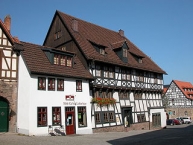
The city of Eisenach developed during the Middle Ages at the exit of Mariental valley, opening to the Hörsel valley around Marktplatz, Karlsplatz and Frauenplan in a triangle structure. The early-modern period brought extensions to the west (Katharinenstraße), to the north (Jakobstraße) and to the east (in front of Nikolaitor gate). The construction boom between 1850 and 1914 led to a strict division in urban development. South of the historic centre, mansion districts were established on the hillsides of Mariental valley, where the rich factory owners, rentiers and other upper-class people lived. These districts are among the most important examples of this urban type in Germany, and one of the largest in Europe. North of the historic centre, next to the railway and Hörsel river, factories and worker quarters were established. These also host some examples of interesting Gründerzeit architecture. After World War I, the city extended further to the north on the other bank of Hörsel river, where some new residential areas were developed before 1990.
Square ensembles
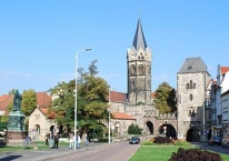
- Karlsplatz: adjoins the Nikolaikirche (Church of St. Nicholas) and the Romanesque Nikolaitor (St. Nicholas Gate), the only surviving city gate (out of 5)in the town. The square is seen as the nucleus of the town, it was first mentioned in 1368.
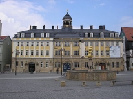
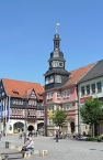
- Marktplatz: the market square with the Georgenkirche (Church of St. George), the town hall, the Baroque Stadtschloss, as well as a number of highly decorative administration buildings and merchants' houses. It also features the gilded market fountain designed by Hans Leonardt in 1549, showing St. George, the patron saint of Eisenach.
- Jakobsplan: named after a chapel destroyed by fire in the Middle Ages. Jakobsplan comprises a monument to St. George in the centre of the square, part of the old town walls (including one of the watch towers), and the Goethe Garden.
- Frauenplan: a small courtyard-type square that takes its name from the "Church of Our Lady". The church was demolished for defence purposes in 1306. Today Frauenplan is the location of the Bachhaus and the Bach monument in front of it.
Churches
- St. George's Church at the market square was first built in the 12th century. The church in which St. Elisabeth was married was demolished in 1515 and replaced by a new structure. Martin Luther held a sermon there on 2 May 1521. Inn 1525, the church was heavily damaged during the Bauernkrieg and during the Reformation it served as a stables. It was rededicated in 1558. On 23 March 1685, Johann Sebastian Bach was baptized in the church (the 16th century baptismal font still remains). The tower was added in 1898–1902.
- St. Nicholas' Church, located on the Karlsplatz, served the Benedictine convent once located in the area. This triple-naved basilica was built in 1180. It is considered the latest example of Romanesque architecture in Thuringia.
- Preacher's Church at Predigerplatz was part of a former Dominican monastery (founded in 1240 and the only monastery buildings of which remain in the town), today used as a museum for medieval art.
- St. Elizabeth's Church at Sophienstraße is the Catholic parish church of Eisenach, built in neo-Gothic style in the 1880s.
- St. Anne's Church at Georgenstraße was founded together with a hospital by St. Elizabeth in 1226.
- St. Clement's Chapel at Clemensstraße is a small 13th century Romanesque chapel.
- Holy Cross Churchat the old cemetery was built in the 1690s
Castles and palaces
- The most important castle is the Wartburg above the city. For further information, see: Wartburg
 .
. - The Stadtschloss (town palace) is situated at the north end of the Marktplatz and was built between 1742 and 1745. This palace was constructed to the plans of Gottfried Heinrich Krohne, architect of Ernst August I, Duke of Saxe-Weimar. After 1777 Johann Wolfgang von Goethe frequently stayed here in his capacity as the duke's prime minister. Today the Stadtschloss acts as a venue for special exhibitions and as a museum for artistic and historical artifacts from Thuringia.
- Hellgrevenhof at Georgenstraße is part of a former inner-city castle, named after Heinrich Hellgreve, a rich citizen who lived here in the late 13th century. It consists of five buildings, the oldest dating to around 1200, although it has been modified several times over the centuries.
- Bechtolsheim Palace at Jakobsplan is a neoclassical palace, built in the late 18th century.
- Schloss Fischbach in Fischbach district is a small 17th-century castle.
- Jagdschloss Hohe Sonne is a hunting lodge south of the city in the Thuringian Forest. It was built in the mid-18th century in the Baroque style.
- Alte Residenz at Esplanade is the relic of the former ducal residence, rebuilt in the Renaissance style after older predecessors.
- The most important castle is the Wartburg above the city. For further information, see: Wartburg
Information about copyright | |
|---|---|
Rights characteristic / license | by-sa: CREATIVE COMMONS Attribution-ShareAlike |
Link to the description of the license | |
Input taken over from: |
Wikipedia contributors, 'Eisenach', Wikipedia, The Free Encyclopedia, 3 September 2014, 06:42 UTC, http://en.wikipedia.org/w/index.php?title=Eisenach&oldid=623969340 [accessed 18 September 2014] |
taken over / edited on | 18 Sep 2014 - 03 Feb 2020
|
taken over / edited by |
|
![]()