
Rhineland-Palatinate Cycle Route
Actions
![]()
Please wait - map data are loading
Added on 23 Jul 2013,
last edited by biroto-Redaktion on 30 Aug 2023
Actions
Cycle route metrics
Total distance in km
1.040
Information about rights to the gps-track data | |
|---|---|
Rights owner | OpenStreetMap and Contributors + biroto-Redaktion (biroto.eu) |
Rights characteristic / license | Contains information from OpenStreetMap, which is made available here under the Open Database License(ODbL) |
Link to the description of the license | |
GPX file taken from | |
GPX file uploaded | by biroto-Redaktion on 30 Aug 2023
|
Track points in total
17.854
Track points per km (avg)
17
Start/endpoint
Start location
Mainz, RP, DE (88 m NHN)
End location
Mainz, RP, DE (89 m NHN)
Signposting
|

Travel reports about cycle tours

Information about copyright | |
|---|---|
Rights owner | |
Rights characteristic / license | by-sa: CREATIVE COMMONS Attribution-ShareAlike |
Link to the description of the license | |
Image has been uploaded | by ThimbleU on 22 Aug 2023
|
05 Jul 2023
100 km
A stage of the tour »Aachen - Vennbahn - Mosel - Saar - Mosel - Erft - Solingen« of user ThimbleU
Information about copyright | |
|---|---|
Rights owner | |
Rights characteristic / license | by-sa: CREATIVE COMMONS Attribution-ShareAlike |
Link to the description of the license | |
Image has been uploaded | by ThimbleU on 23 Aug 2023
|
06 Jul 2023
91 km
A stage of the tour »Aachen - Vennbahn - Mosel - Saar - Mosel - Erft - Solingen« of user ThimbleU
Beds4Cyclists, worth visiting and infrastructure
Name and address
Latitude / Longitude
Phone
Fax
Mobile
Type of accommodation
Rating for cyclists
Route km
Dist. to route
Elevation
4 km
1,3 km
90 m
Information about copyright | |
|---|---|
Rights owner | - |
Rights characteristic / license | cc0: Public Domain no Rights reserved |
Link to the description of the license | |
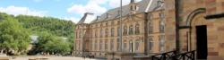
Image taken over from | https://commons.wikimedia.org/wiki/File:Wiesbaden_Castle.jpg |
Image has been uploaded | by biroto-Redaktion on 30 Jan 2018
|
Information about copyright | |
|---|---|
Rights owner | |
Rights characteristic / license | by-sa: CREATIVE COMMONS Attribution-ShareAlike |
Link to the description of the license | |
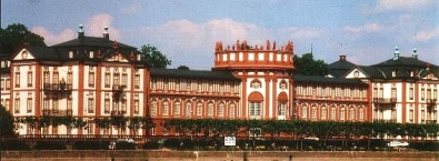
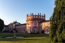
Image taken over from | https://commons.wikimedia.org/wiki/File:Schloss_Biebrich,_Nordseite,_150726,_ako.jpg |
Image has been uploaded | by biroto-Redaktion on 30 Jan 2018
|
Das Schloss Biebrich war die barocke Residenz der Fürsten und späteren Herzöge von Nassau am Rheinufer in Biebrich ![]() (1926 eingemeindet nach Wiesbaden
(1926 eingemeindet nach Wiesbaden ![]() ).
).
Das Gebäude entstand nicht nach einem einheitlichen Entwurf, sondern wurde zwischen 1700 und 1750 immer wieder erweitert, bis sich schließlich aus einem Gartenhäuschen eine dreiflügelige Anlage entwickelt hatte. Als solche zählt sie heute zu den bedeutendsten Barockschlössern am Rhein. Auf der vom Rhein abgewandten Seite breitet sich der weitläufige Schlosspark aus, in dem alljährlich an Pfingsten ein bekanntes Reitturnier stattfindet. Im Schloss ist unter anderem das Hessische Landesamt für Denkmalpflege untergebracht. Daneben dient es Repräsentationszwecken der Hessischen Landesregierung.
Das Schloss stellt sich heute als Dreiflügel-Anlage dar, bestehend aus dem West- und dem Ostflügel, die sich an die äußeren Pavillons anschließen sowie der dazwischen liegenden Rotunde, die mit den beiden äußeren Pavillons durch zwei Galerien verbunden ist. Das Ensemble erhielt zunächst 1965, dann endgültig 1982 seinen ursprünglichen rot-weißen Anstrich zurück, was zum einheitlichen Gesamteindruck beiträgt. Beim näheren Betrachten kann man jedoch die architektonischen Unterschiede erkennen, die sich aus der langen Bauzeit ergeben haben.
Heutige Nutzung
Das Schloss ist im Eigentum des Landes Hessen. Die Rotunde, die Galerien und die Erdgeschosse der Pavillons dienen als repräsentative Kulisse für Empfänge der Landesregierung sowie anderer Behörden und als städtisches Standesamt. Außerdem sind mehrere Behörden im Schloss untergebracht. Das Untergeschoss der Rotunde nutzt ein Café.
Der Schlosspark ist frei zugänglich. Er verbindet das am Rhein gelegene Schloss mit der künstlichen Ruine Mosburg ![]() .
.
Information about copyright | |
|---|---|
Rights characteristic / license | by-sa: CREATIVE COMMONS Attribution-ShareAlike |
Link to the description of the license | |
Input taken over from: |
Seite „Schloss Biebrich“. In: Wikipedia, Die freie Enzyklopädie. Bearbeitungsstand: 13. Juni 2017, 19:10 UTC. URL: https://de.wikipedia.org/w/index.php?title=Schloss_Biebrich&oldid=166362471 (Abgerufen: 29. Januar 2018, 23:13 UTC) |
taken over / edited on | 30 Jan 2018
|
taken over / edited by |
|
9 km
0,7 km
86 m
12 km
1,8 km
108 m
13 km
1,8 km
109 m
13 km
1,6 km
90 m
Information about copyright | |
|---|---|
Rights owner | |
Rights characteristic / license | by-sa: CREATIVE COMMONS Attribution-ShareAlike |
Link to the description of the license | |
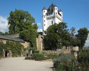
Image taken over from | commons.wikimedia.org/wiki/File:Eltville_Castle_Middle_Rhine_Germany.jpg |
Image has been uploaded | by biroto-Redaktion on 18 Dec 2011
|
Die Kurfürstliche Burg Eltville wurde 1345 unter Erzbischof Balduin alsw dessen Residenz fertiggestellt.
Die „Kurfürstliche Burg Eltville“ beherbergt eine Gutenberg-Gedenkstätte mit historischer Sammlung über die Druckkunst sowie eine „Galerie im Turm“ für Kunstausstellungen und ist Austragungsort vieler kultureller Veranstaltungen, wie bis 2007 die Burghofspiele Eltville. Des Weiteren befindet sich in der Burg der Sitz des örtlichen Standesamtes.
Information about copyright | |
|---|---|
Rights characteristic / license | by-sa: CREATIVE COMMONS Attribution-ShareAlike |
Link to the description of the license | |
Input taken over from: |
aus Wikipedia: Burg Eltville Stand 13.07.2011 |
taken over / edited on | 13 Jul 2011 - 18 Dec 2011
|
taken over / edited by |
|
Hours of opening
- Außenanlage (Burghof, Rosengarten, Wehrgang)
April bis Mitte Oktober: täglich 9.30–19 Uhr
Mitte Oktober bis März: täglich 10.30–17 Uhr - Burgturm
April bis Mitte Oktober:
Fr 14–18 Uhr
Sa/So/Feiertag 11–18 Uhr
Mitte Oktober bis März geschlossen - Historische Sammlung im Burgturm:
April bis Mitte Oktober: So 15–17 Uhr
![]()