
River Main Cycle Route (variant White Main)
Actions
![]()
Please wait - map data are loading
Added on 06 Jan 2013,
last edited by biroto-Redaktion on 16 Mar 2024
Actions
Cycle route metrics
Total distance in km
544
Information about rights to the gps-track data | |
|---|---|
Rights owner | OpenStreetMap and Contributors + biroto-Redaktion (biroto.eu) |
Rights characteristic / license | Contains information from OpenStreetMap, which is made available here under the Open Database License(ODbL) |
Link to the description of the license | |
GPX file taken from | |
GPX file uploaded | by biroto-Redaktion on 16 Mar 2024
|
Track points in total
8.474
Track points per km (avg)
16
Start/endpoint
Start location
Bischofsgrün, Bayern, DE (680 m NHN)
End location
Wiesbaden, Hessen, DE (85 m NHN)
Character
Der Main-Radweg ist ein etwa 600 Kilometer langer Radfernweg in Franken und Hessen. Er beginnt an der Quelle des Weißen Mains ![]() am Ochsenkopf bei Bischofsgrün und bei der Quelle des Roten Mains
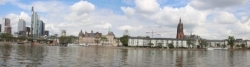
am Ochsenkopf bei Bischofsgrün und bei der Quelle des Roten Mains ![]() in Creußen. Nach jeweils etwa 50 km vereinigen sich die beiden Quellarme bei Kulmbach zum Main. Der Main-Radweg führt von dort weiter über Bamberg, Schweinfurt, Würzburg, Aschaffenburg, Hanau, Offenbach und Frankfurt bis zum Rhein in Mainz-Kastel, das gegenüber dem Zentrum von Mainz liegt.
in Creußen. Nach jeweils etwa 50 km vereinigen sich die beiden Quellarme bei Kulmbach zum Main. Der Main-Radweg führt von dort weiter über Bamberg, Schweinfurt, Würzburg, Aschaffenburg, Hanau, Offenbach und Frankfurt bis zum Rhein in Mainz-Kastel, das gegenüber dem Zentrum von Mainz liegt.
Der Allgemeine Deutsche Fahrrad-Club(ADFC) zeichnete den Weg im Jahr 2008 als ersten deutschen Radfernweg mit fünf Sternen aus. Laut ADFC führen 90 % des Radwegs durch naturnahe und landschaftlich reizvolle Gebiete. Weiterhin sind 90 % asphaltiert, und 77 % der Strecke sind breiter als 2,50 Meter. Ausgeschildert ist immer nur eine Uferseite, obwohl das Mainufer streckenweise beidseitig mit dem Rad befahrbar ist.
Information about copyright | |
|---|---|
Rights characteristic / license | by-sa: CREATIVE COMMONS Attribution-ShareAlike |
Link to the description of the license | |
Input taken over from: |
Seite „Main-Radweg“. In: Wikipedia, Die freie Enzyklopädie. Bearbeitungsstand: 5. Januar 2013, 23:12 UTC. URL: http://de.wikipedia.org/w/index.php?title=Main-Radweg&oldid=112569087 |
taken over / edited on | 06 Jan 2013 - 16 Mar 2024
|
taken over / edited by |
|
Signposting
|

Sources of information
Web-Sites:
- official Web-site of the Main Cycle Route
Cycling guides/maps:
- Esterbauer bikleline: Main-Radweg: From Bayreuth to Mainz.
Cycling guide1:75 000, weatherproof/tearproof, 2015, German, 160 p.
Connecting cycle path
- bei Bischofsgrün
- bei Bad Berneck
- bei Melkendorf
- bei Bamberg
- bei Schweinfurt
- bei Würzburg
- bei Gemünden
- bei Wertheim
- bei Freudenberg
- bei Miltenberg
- bei Großkrotzenburg
- bei Hanau
- bei Rumpenheim
- bei Höchst
- bei Mainz
Remarks
Diese Variante des Main Radweges beginnt im Bischofsgrüner Forst und folgt bis Melkendorf dem Weißen Main. Alternativ siehe Main-Radweg (Variante Roter Main).
Travel reports about cycle tours
16 Aug 2013
94 km
A stage of the tour »River Main Cycle Route and Middle Rhine Valley« of user ThimbleU
17 Aug 2013
83 km
A stage of the tour »River Main Cycle Route and Middle Rhine Valley« of user ThimbleU
18 Aug 2013
94 km
A stage of the tour »River Main Cycle Route and Middle Rhine Valley« of user ThimbleU
19 Aug 2013
98 km
A stage of the tour »River Main Cycle Route and Middle Rhine Valley« of user ThimbleU
20 Aug 2013
98 km
A stage of the tour »River Main Cycle Route and Middle Rhine Valley« of user ThimbleU
Beds4Cyclists, worth visiting and infrastructure
Name and address
Latitude / Longitude
Phone
Fax
Mobile
Type of accommodation
Rating for cyclists
Route km
Dist. to route
Elevation
0 km
1,3 km
672 m
12 km
0,9 km
394 m
12 km
0,8 km
399 m
Information about copyright | |
|---|---|
Rights owner | |
Rights characteristic / license | by-sa: CREATIVE COMMONS Attribution-ShareAlike |
Link to the description of the license | |
Image taken over from | https://commons.wikimedia.org/wiki/File:Bad_Berneck_(Marktplatz,_30.07.1991).jpg |
Image has been uploaded | by biroto-Redaktion on 05 Jan 2020
|

Information about copyright | |
|---|---|
Rights owner | |
Rights characteristic / license | by-sa: CREATIVE COMMONS Attribution-ShareAlike |
Link to the description of the license | |
Image taken over from | https://commons.wikimedia.org/wiki/File:Bad_Berneck_Marktplatz.JPG |
Image has been uploaded | by biroto-Redaktion on 05 Jan 2020
|
Information about copyright | |
|---|---|
Rights owner | |
Rights characteristic / license | by-sa: CREATIVE COMMONS Attribution-ShareAlike |
Link to the description of the license | |
Image taken over from | https://commons.wikimedia.org/wiki/File:Dreifaltigkeitskirche_-_Bad_Berneck_051.jpg |
Image has been uploaded | by biroto-Redaktion on 05 Jan 2020
|
Information about copyright | |
|---|---|
Rights owner | https://web.archive.org/web/20161024231442/www.panoramio.com/user/5436158?with_photo_id=81174 |
Rights characteristic / license | by: CREATIVE COMMONS Attribution |
Link to the description of the license | |
Image taken over from | https://commons.wikimedia.org/wiki/File:Burgruine_Hohenberneck_-_panoramio.jpg |
Image has been uploaded | by biroto-Redaktion on 05 Jan 2020
|
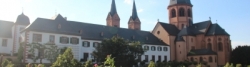
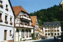
Die Kleinstadt Bad Berneck liegt am Rande des Fichtelgebirges im Norden von Oberfranken. Bad Berneck ist seit 1857 ein Kurort, zuerst Molken- und Luftkurort, seit 1930 Kneippkurort und seit 1950 Kneippsches Heilbad. Die Stadt liegt in den Tälern der Ölschnitz und des Weißen Mains am Westrand des Fichtelgebirges.
Sehenswürdigkeiten
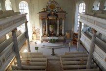
- Bad Berneck besitzt eine sehenswerte Altstadt mit Fachwerkhäusern und einem ⊙ Historischer Marktplatz
- Der ⊙ Kurpark im Ölschnitztal lädt zum Spaziergang ein. Auf einem Lehrpfad werden die fünf Säulen der Kneipp`schen Lehre veranschaulicht. Sehenswert sind auch die Alte (1889) und die Neue Kolonnade mit der Wandelhalle.
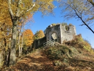
- Auf dem ⊙ Schlossberg kann man die Ruinen der Walpoten-Burg, ⊙ Burg Hohenberneck mit zugehöriger Burgkapelle entdecken.
- ⊙ Ein Lehrpfand mit Schautafeln befindet sich im Dendrologischen Garten (Dentrologie ist die Lehre von den Bäumen und Gehölzen) im Rotherspark.
Küche
Eine Besonderheit sind die Brezen. Der Name kommt daher, dass während der Brezenwochen, in der Faschingszeit, Anisbrezen auf jeden Tisch stehen, bzw. gereicht werden. In diesen Wochen haben die verschiedenen Wirtshäuser wochenweise nacheinander Brezen. Damit verbunden sind besondere Gerichte, wie Krenfleisch und verschieden Braten. Es wird eine aufwändigere Küche als sonst betrieben. Viele Einheimische gehen jede Woche in ein anderes Wirtshaus ´auf die Brezen´, dadurch sind die Gaststätten gut gefüllt und man muss rechtzeitig kommen um einen Platz zu ergattern.
- ⊙Gasthof „Drei Linden“, Kolonnadenweg 26. ☎ +49 9273 7506. Fränkische, niederbayerische und irische Küche.
- ⊙Gasthof „Kutscherstuben“, Rimlasgrund 2. ☎ +49 9273 1757.
Information about copyright | |
|---|---|
Rights characteristic / license | by-sa: CREATIVE COMMONS Attribution-ShareAlike |
Link to the description of the license | |
Input taken over from: |
Wikivoyage-Bearbeiter, 'Bad Berneck', Wikivoyage, Freie Reiseinformationen rund um die Welt, 8. Juni 2019, 20:44 UTC, https://de.wikivoyage.org/w/index.php?title=Bad_Berneck&oldid=1212080 [abgerufen am 5. Januar 2020] |
taken over / edited on | 05 Jan 2020
|
taken over / edited by |
|
12 km
1,0 km
416 m
13 km
0,0 km
353 m
e-Bike-Ladestation Lenkeit Bad Berneck
DE-95460 Bad Berneck
e-bike charging station
![]()