
Saale Cycle Route
Actions
![]()
Please wait - map data are loading
Added on 06 Feb 2012,
last edited by biroto-Redaktion on 08 Nov 2023
Actions
Cycle route metrics
Total distance in km
408
Information about rights to the gps-track data | |
|---|---|
Rights owner | OpenStreetMap and Contributors + biroto-Redaktion (biroto.eu) |
Rights characteristic / license | Contains information from OpenStreetMap, which is made available here under the Open Database License(ODbL) |
Link to the description of the license | |
GPX file taken from | |
GPX file uploaded | by biroto-Redaktion on 08 Nov 2023
|
Track points in total
8.404
Track points per km (avg)
21
Start/endpoint
Start location
Zell im Fichtelgebirge, BY, DE (721 m NHN)
End location
Barby, ST, DE (48 m NHN)
Signposting
|

Sources of information
Portal des Saale-Radweges
Bücher/Karten:
- Esterbauer bikeline: Radtourenbuch Saale-Radweg: Vom Fichtelgebirge zur Elbe. 1:50.000, 409 km, wetterfest/reißfest
- Kompass: Fahrrad-Tourenkarte Saaleradweg - Von Münchberg nach Schönebeck (Elbe), 1:50.000.
Connecting cycle path
- in Zell Radweg Ostsee - Oberbayern (D11)
- in Hirschberg Radweg Grünes Band Deutschland
- in Blankenberg Radweg Grünes Band Deutschland
- in Jena Radweg Mittellandroute (D4)
- bei Großheringen Ilmtal-Radweg
- bei Naumburg Unstrut-Radweg
- bei Bernburg
- bei Nienburg
- bei Barby Elberadweg (D10)
Remarks
Hinweis aus der biroto-Community: "...Ich bin im Mai 2022 den Radweg ( Ostsee - Oberbayern) von Rostock bis Rosenheim gefahren. Schwierig wurde es auf dem Saale-Radweg von Saalfeld bis Schwarzenbach. Bei Fluss-Radwegen erwartet man nicht unbedingt ständige Steigungen. Dies ist hier aber wegen den Talsperren anders. Hier kommt eine Steigung nach der nächsten. Dabei so schöne Sachen wie 12% zwei Kilometer den Waldweg hinauf. Ich habe auf dem Teilstück auch kaum normale Radwanderer getroffen. Nur Sportler." |
Travel reports about cycle tours
22 Sep 2021
72 km
A stage of the tour »Forchheim - Halle - Brunswick« of user ThimbleU
23 Sep 2021
84 km
A stage of the tour »Forchheim - Halle - Brunswick« of user ThimbleU
24 Sep 2021
93 km
A stage of the tour »Forchheim - Halle - Brunswick« of user ThimbleU
25 Sep 2021
67 km
A stage of the tour »Forchheim - Halle - Brunswick« of user ThimbleU
26 Sep 2021
91 km
A stage of the tour »Forchheim - Halle - Brunswick« of user ThimbleU
Beds4Cyclists, worth visiting and infrastructure
Name and address
Latitude / Longitude
Phone
Fax
Mobile
Type of accommodation
Rating for cyclists
Route km
Dist. to route
Elevation
0 km
4,6 km
654 m
0 km
0,0 km
709 m
Information about copyright | |
|---|---|
Rights owner | |
Rights characteristic / license | by-sa: CREATIVE COMMONS Attribution-ShareAlike |
Link to the description of the license | |
Image taken over from | |
Image has been uploaded | by biroto-Redaktion on 20 Aug 2012
|
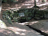
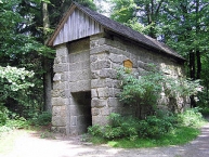
Die Saalequelle ist der Ursprung der Saale, eines der vier großen Flüsse des Fichtelgebirges ![]() .
.
Die Saalequelle liegt auf dem Gebiet der Gemeinde Zell im Fichtelgebirge ![]() am Fuße des Großen Waldsteins
am Fuße des Großen Waldsteins ![]() im Fichtelgebirge
im Fichtelgebirge ![]() . Die eigentliche Quelle der Saale befindet sich knapp 60 Meter hinter der heutigen Fassung, die bis 1869 als "Ausgang der Saale" bezeichnet worden ist.
. Die eigentliche Quelle der Saale befindet sich knapp 60 Meter hinter der heutigen Fassung, die bis 1869 als "Ausgang der Saale" bezeichnet worden ist.
Information about copyright | |
|---|---|
Rights characteristic / license | by-sa: CREATIVE COMMONS Attribution-ShareAlike |
Link to the description of the license | |
Input taken over from: |
Seite „Saalequelle“. In: Wikipedia, Die freie Enzyklopädie. Bearbeitungsstand: 7. Juli 2012, 22:52 UTC. URL: http://de.wikipedia.org/w/index.php?title=Saalequelle&oldid=105305120 (Abgerufen: 20. August 2012, 14:30 UTC) |
taken over / edited on | 20 Aug 2012
|
taken over / edited by |
|
2 km
0,1 km
608 m
2 km
0,1 km
603 m
3 km
2,1 km
844 m
Information about copyright | |
|---|---|
Rights owner | |
Rights characteristic / license | by-sa: CREATIVE COMMONS Attribution-ShareAlike |
Link to the description of the license | |
Image taken over from | |
Image has been uploaded | by biroto-Redaktion on 20 Aug 2012
|
Information about copyright | |
|---|---|
Rights owner | |
Rights characteristic / license | by-sa: CREATIVE COMMONS Attribution-ShareAlike |
Link to the description of the license | |
Image taken over from | commons.wikimedia.org/wiki/File:Kapelle_Grosser_Waldstein.jpg |
Image has been uploaded | by biroto-Redaktion on 20 Aug 2012
|
Information about copyright | |
|---|---|
Rights owner | |
Rights characteristic / license | by-sa: CREATIVE COMMONS Attribution-ShareAlike |
Link to the description of the license | |
Image taken over from | |
Image has been uploaded | by biroto-Redaktion on 20 Aug 2012
|
Information about copyright | |
|---|---|
Rights owner | |
Rights characteristic / license | by-sa: CREATIVE COMMONS Attribution-ShareAlike |
Link to the description of the license | |
Image taken over from | commons.wikimedia.org/wiki/File:Grosser_Waldstein_Schuessel.jpg |
Image has been uploaded | by biroto-Redaktion on 20 Aug 2012
|
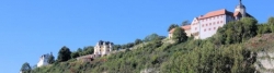
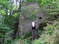
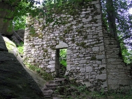
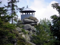
Der Große Waldstein (877 m ü. NN) ist Teil des Waldsteinzuges ![]() im nördlichen Fichtelgebirgs-Hufeisen
im nördlichen Fichtelgebirgs-Hufeisen ![]() . Bekannt ist er vor allem durch seine Felsen in Wollsackverwitterung
. Bekannt ist er vor allem durch seine Felsen in Wollsackverwitterung ![]() , seine Schlossruinen und den einzigen erhaltenen Bärenfang der Region,
, seine Schlossruinen und den einzigen erhaltenen Bärenfang der Region,
- Burgruine Rotes Schloss
Östlich gegenüber dem Waldsteinhaus erhebt sich eine mächtige Felswand, auf der die Reste der einst mächtigen Veste Waldstein thronen. Diese Burg wird heute oft als Rotes Schloss bezeichnet, da man lange Zeit davon ausging, dass der Palas schon seit seiner Erbauung im 14. Jahrhundert mit roten Ziegeln gedeckt war. - Teufelstisch
Vor der Burgpforte befindet sich ein mächtiger, nach oben sich erweiternder Felsblock mit ovaler Platte, der sagenumwobene Teufelstisch. Auf der Platte dieses eigenartigen Felsmassivs kann man noch heute tiefe Löcher sehen, die der Sage nach von eisernen Karten herrühren, mit denen der Teufel zusammen mit Kobolden und Geistern gespielt hat. - ehemalige Ostburg
Vor dem Aufgang zum Aussichtspavillon Schüssel sind die Mauerreste einer spätromanischen Kapelle zu sehen, die zur Ostburg gehörte. Am nordöstlichen Fuß des Schüsselfelsens befinden sich Mauerreste der Ostburg, um 1100 angelegt, um 1300 wegen der Anlage der neuen Westburg aufgegeben. - Die Schüssel
Eine kesselartige Vertiefung auf dem höchsten Felsen des Waldsteins, auf den eine Besteigungsanlage führt, gab einst dem Felsen den Namen. Dieser Name übertrug sich auf den Aussichtspavillon, der 1851 vom Revierförster errichtet wurde. - Bärenfang
200 m westlich vom Waldsteinhaus steht der Bärenfang, urkundlich erstmals am 3. April 1656 erwähnt, ist er heute der einzige seiner Art in Deutschland.
Information about copyright | |
|---|---|
Rights characteristic / license | by-sa: CREATIVE COMMONS Attribution-ShareAlike |
Link to the description of the license | |
Input taken over from: |
Seite „Großer Waldstein“. In: Wikipedia, Die freie Enzyklopädie. Bearbeitungsstand: 7. Juli 2012, 11:43 UTC. URL: http://de.wikipedia.org/w/index.php?title=Gro%C3%9Fer_Waldstein&oldid=105283605 (Abgerufen: 20. August 2012, 14:20 UTC) |
taken over / edited on | 20 Aug 2012
|
taken over / edited by |
|
![]()