
Sieg Valley Cycle Route
Actions
![]()
Please wait - map data are loading
Added on 05 Jul 2013,
last edited by biroto-Redaktion on 20 Apr 2024
Actions
Cycle route metrics
Total distance in km
150
Information about rights to the gps-track data | |
|---|---|
Rights owner | OpenStreetMap and Contributors + biroto-Redaktion (biroto.eu) |
Rights characteristic / license | Contains information from OpenStreetMap, which is made available here under the Open Database License(ODbL) |
Link to the description of the license | |
GPX file taken from | |
GPX file uploaded | by biroto-Redaktion on 20 Apr 2024
|
Track points in total
3.087
Track points per km (avg)
21
Start/endpoint
Start location
Netphen, Nordrhein-Westfalen, DE (616 m NHN)
End location
Niederkassel, Nordrhein-Westfalen, DE (56 m NHN)
Character
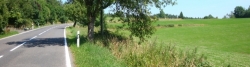
Der Siegtal-Radweg verläuft überwiegend auf befestigten Wegen und Straßen, im oberen Bereich gibt es auch einige kurze unbefestigte Abschnitte. Die stark frequentierte Straße durch das Siegtal befindet sich praktisch immer in Hörweite. Überwiegend verläuft der Weg auf straßenbegleitenden Radwegen, wobei die Qualität hinsichtlich Wegbreite und Oberflächenqualität teilweise als mangelhaft einzustufen ist. Im mittleren Abschnitt der Sieg zwischen Siegen und Rosbach folgt die Siegtalroute vielfach der B62 und der B256, wobei häufig kein Radweg vorhanden ist. Auch ist die Beschilderung des Radwegs besonders in diesem Abschnitt sehr lückenhaft.
Zur Mündung in den Rhein hin weitet sich das Siegtal, so dass der Radweg hier teilweise die Straße verlässt. Ab Rosbach gibt es bis hinter Schladern einen schönen kombinierten Fuß-/Radweg. Ab Dattenfeld ist der Radweg fast durchgängig bis zur Siegmündung (59,3 km). Eine Unterbrechung gibt es lediglich in Lützgenauel. Zwischen Merten und Auel folgt der Weg dem Bahndamm und überquert auf einem Radfahrsteg an der Eisenbahnbrücke, der im Rahmen der Regionale 2010 gebaut wurde, die Sieg. Ab Hennef fährt man teilweise auf dem Siegdamm auf qualitativ gute Wegen (teils Asphalt, teils feiner Schotter) bis zur Siegmündung. Der Weg wird lediglich durch kurze Straßenabschnitte bei Stadtquerungen unterbrochen.
Information about copyright | |
|---|---|
Rights characteristic / license | by-sa: CREATIVE COMMONS Attribution-ShareAlike |
Link to the description of the license | |
Input taken over from: |
Seite „Siegtal-Radweg“. In: Wikipedia, Die freie Enzyklopädie. Bearbeitungsstand: 4. Oktober 2012, 11:38 UTC. URL: http://de.wikipedia.org/w/index.php?title=Siegtal-Radweg&oldid=108864104 |
taken over / edited on | 05 Jul 2013 - 20 Apr 2024
|
taken over / edited by |
|
Signposting
|

Travel reports about cycle tours
Information about copyright | |
|---|---|
Rights owner | |
Rights characteristic / license | by-sa: CREATIVE COMMONS Attribution-ShareAlike |
Link to the description of the license | |
Image has been uploaded | by Rolando on 25 Sep 2014
|
19 Jul 2014
66 km
A stage of the tour »Aachen - Dresden auf der Mittellandroute« of user Rolando
Information about copyright | |
|---|---|
Rights owner | |
Rights characteristic / license | by-sa: CREATIVE COMMONS Attribution-ShareAlike |
Link to the description of the license | |
Image has been uploaded | by Rolando on 21 Sep 2014
|
18 Jul 2014
67 km
A stage of the tour »Aachen - Dresden auf der Mittellandroute« of user Rolando
Beds4Cyclists, worth visiting and infrastructure
Name and address
Latitude / Longitude
Phone
Fax
Mobile
Type of accommodation
Rating for cyclists
Route km
Dist. to route
Elevation
6 km
2,4 km
593 m
Information about copyright | |
|---|---|
Rights owner | |
Rights characteristic / license | by-sa: CREATIVE COMMONS Attribution-ShareAlike |
Link to the description of the license | |
Image taken over from | commons.wikimedia.org/wiki/File:Quellteich_der_Lahn_am_Lahnhof.JPG |
Image has been uploaded | by biroto-Redaktion on 13 Nov 2013
|
Information about copyright | |
|---|---|
Rights owner | |
Rights characteristic / license | cc0: Public Domain no Rights reserved |
Link to the description of the license | |
Image taken over from | |
Image has been uploaded | by biroto-Redaktion on 13 Nov 2013
|
Information about copyright | |
|---|---|
Rights owner | |
Rights characteristic / license | by-sa: CREATIVE COMMONS Attribution-ShareAlike |
Link to the description of the license | |
Image taken over from | |
Image has been uploaded | by biroto-Redaktion on 13 Nov 2013
|
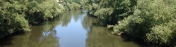
Die Lahn entspringt im südöstlichen Nordrhein-Westfalen an der Grenze zu Hessen im südöstlichen Rothaargebirge auf dem Höhenzug/NaturraumEderkopf-Lahnkopf-Rücken(333.01), auf dem dieRhein-Weser-Wasserscheideauf die Rheinsystem-interne Wasserscheide zwischen Lahn und Sieg trifft.
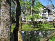
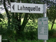
Ihre Quelle, der Lahntopf, befindet sich auf etwa 603 m ü. NHN südwestlich des 624,9 m hohen Lahnkopfs ![]() bei Lahnhof
bei Lahnhof ![]() , einem Ortsteil von Nenkersdorf, das wiederum ein Stadtteil von Netphen
, einem Ortsteil von Nenkersdorf, das wiederum ein Stadtteil von Netphen ![]() ist. In der näheren Umgebung entspringen außerdem die Eder
ist. In der näheren Umgebung entspringen außerdem die Eder ![]() (5,5 km nordwestlich der Lahnquelle) und die Sieg
(5,5 km nordwestlich der Lahnquelle) und die Sieg ![]() (3 km nördlich derselben). Direkt am Lahnursprung vorbei führen Abschnitte des Rothaarsteigs und der Eisenstraße.
(3 km nördlich derselben). Direkt am Lahnursprung vorbei führen Abschnitte des Rothaarsteigs und der Eisenstraße.
Anfang 2013 wurde die junge Lahn im Zuge der Renaturierung unmittelbar unterhalb ihrer Quelle von einer Verrohrung unter einer Wiese auf einer Länge von 300 Metern befreit. Außerdem wurde der Quelltopf gestalterisch aufgewertet. Die Renaturierungsarbeiten wurden wie auch die bei der Siegquelle von einer Baufirma aus Wilnsdorf übernommen.
Information about copyright | |
|---|---|
Rights characteristic / license | by-sa: CREATIVE COMMONS Attribution-ShareAlike |
Link to the description of the license | |
Input taken over from: |
Seite „Lahnquelle“. In: Wikipedia, Die freie Enzyklopädie. Bearbeitungsstand: 14. Oktober 2014, 21:46 UTC. URL: http://de.wikipedia.org/w/index.php?title=Lahnquelle&oldid=134896489 (Abgerufen: 21. Oktober 2014, 15:36 UTC) |
taken over / edited on | 13 Nov 2013 - 21 Oct 2014
|
taken over / edited by |
|
12 km
0,0 km
310 m
24 km
0,0 km
238 m
To avoid the steep slope in the upper Sieg valley go by train from Siegen-Weidenau to Luetzel. In 2014 trains run every hour to xx: 01 from Siegen. Travel time 42 minutes.
Information about copyright | |
|---|---|
Rights characteristic / license | by-sa: CREATIVE COMMONS Attribution-ShareAlike |
Link to the description of the license | |
taken over / edited on | 01 Oct 2014
|
taken over / edited by |
|
26 km
0,3 km
236 m
26 km
2,0 km
334 m
![]()