
Wellness Cycle Route
former cycle route!
Actions
![]()
Please wait - map data are loading
Added on 15 Aug 2012,
last edited by biroto-Redaktion on 28 Oct 2023
Actions
Cycle route metrics
Total distance in km
472
Information about rights to the gps-track data | |
|---|---|
Rights owner | OpenStreetMap and Contributors + biroto-Redaktion (biroto.eu) |
Rights characteristic / license | Contains information from OpenStreetMap, which is made available here under the Open Database License(ODbL) |
Link to the description of the license | |
GPX file taken from | |
GPX file uploaded | by biroto-Redaktion on 28 Oct 2023
|
Track points in total
7.433
Track points per km (avg)
16
Start/endpoint
Start location
Minden, NW, DE (48 m NHN)
End location
Minden, NW, DE (41 m NHN)
Character
Die Wellness-Radroute war ein zwischen dem Ende der 1990er Jahre und 2013 knapp 500 Kilometer langer Radfernweg. Sie führte durch die fünf großen Heilbäder und neun staatlich anerkannten Luft- und Kneipp-Kurorte in der Region Ostwestfalen-Lippe in Nordrhein-Westfalen.
Information about copyright | |
|---|---|
Rights characteristic / license | by-sa: CREATIVE COMMONS Attribution-ShareAlike |
Link to the description of the license | |
taken over / edited on | 28 Oct 2023
|
taken over / edited by |
|
Signposting
Die Wellness-Radroute ist offiziell eingestellt worden, eine (durchgehende) Ausschilderung ist nicht mehr vorhanden.
Beds4Cyclists, worth visiting and infrastructure
Name and address
Latitude / Longitude
Phone
Fax
Mobile
Type of accommodation
Rating for cyclists
Route km
Dist. to route
Elevation
5 km
3,9 km
49 m
76 km
1,5 km
114 m
76 km
2,6 km
99 m
76 km
2,5 km
150 m
Information about copyright | |
|---|---|
Rights owner | |
Rights characteristic / license | by-sa: CREATIVE COMMONS Attribution-ShareAlike |
Link to the description of the license | |
Image taken over from | |
Image has been uploaded | by biroto-Redaktion on 10 Jan 2014
|
Information about copyright | |
|---|---|
Rights owner | |
Rights characteristic / license | by: CREATIVE COMMONS Attribution |
Link to the description of the license | |
Image taken over from | |
Image has been uploaded | by biroto-Redaktion on 10 Jan 2014
|
Information about copyright | |
|---|---|
Rights owner | |
Rights characteristic / license | by-sa: CREATIVE COMMONS Attribution-ShareAlike |
Link to the description of the license | |
Image taken over from | |
Image has been uploaded | by biroto-Redaktion on 10 Jan 2014
|
Information about copyright | |
|---|---|
Rights owner | |
Rights characteristic / license | by-sa: CREATIVE COMMONS Attribution-ShareAlike |
Link to the description of the license | |
Image taken over from | commons.wikimedia.org/wiki/File:Bi_Sparrenburg_innen_wide.jpg |
Image has been uploaded | by biroto-Redaktion on 10 Jan 2014
|
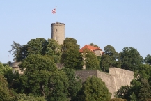
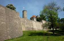
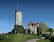
Sparrenberg Castle, also known as the Sparrenburg (German: Burg und Festung Sparrenberg or Sparrenburg), is a restored fortress in the Bielefeld-Mitte district of Bielefeld ![]() , Germany. It is situated on the Sparrenberg hill (180 m or 591 ft altitude) in the Teutoburg Forest and towers 60 m (197 ft) above the city centre. Its current appearance mainly originated in the 16th and 19th century. The Sparrenburg is considered to be Bielefeld's landmark.
, Germany. It is situated on the Sparrenberg hill (180 m or 591 ft altitude) in the Teutoburg Forest and towers 60 m (197 ft) above the city centre. Its current appearance mainly originated in the 16th and 19th century. The Sparrenburg is considered to be Bielefeld's landmark.
The Sparrenburg was erected as a castle sometime before 1250 by the counts of Ravensberg. Following the discovery of gunpowder and the resultant increasing use of cannon and other firearms, the new counts of Ravensberg and the owners of the Sparrenburg, the dukes of Cleves, ordered the expansion of the castle into a fortress of theEarly Modern Periodthat could withstand bombardment from siege guns and also employ its own cannon.
At the end of the 17th century, the Sparrenburg no longer met the military requirements. Therefore, it was partly used as a prison, and partly subjected to decline. The outer walls were torn down by agreement of KingFrederick II of Prussiaand were used for the construction of the barracks 55, which still stands at the Hans-Sachs-Straße.
In 1879, the city of Bielefeld was able to buy the complex from Prussia for a sum of 8,934.90 Marks, although the original value was assessed 70,000.00 Marks. After long discussions concerning the building's design the construction of the new great hall building was started in 1886 using building plans of the architect E. Hillebrand. On April 24, 1888, thegothicbuilding with ballroom, restaurant, and museum rooms was opened.
Information about copyright | |
|---|---|
Rights characteristic / license | by-sa: CREATIVE COMMONS Attribution-ShareAlike |
Link to the description of the license | |
Input taken over from: |
Wikipedia contributors, 'Sparrenberg Castle', Wikipedia, The Free Encyclopedia, 23 December 2013, 10:00 UTC, http://en.wikipedia.org/w/index.php?title=Sparrenberg_Castle&oldid=587354218 [accessed 10 January 2014] |
taken over / edited on | 10 Jan 2014
|
taken over / edited by |
|
Hours of opening
Ascent of the tower
April - October: daily 10.00 - 18.00
Guided Tours
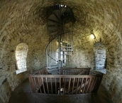
Visit to the casemates (underground passages)
April - October:
Guided tours daily at 11.00 and 14.30
Guided tours for groups by appointment
113 km
2,6 km
77 m
![]()