
Cycle Route West-East-Cycle-Route Lower Saxony
Actions
![]()
Please wait - map data are loading
Added on 15 Oct 2014,
last edited by biroto-Redaktion on 24 Nov 2020
Actions
Cycle route metrics
Total distance in km
449
Information about rights to the gps-track data | |
|---|---|
Rights owner | OpenStreetMap and Contributors + biroto-Redaktion (biroto.eu) |
Rights characteristic / license | Contains information from OpenStreetMap, which is made available here under the Open Database License(ODbL) |
Link to the description of the license | |
GPX file taken from | |
GPX file uploaded | by biroto-Redaktion on 24 Nov 2020
|
Track points in total
5.197
Track points per km (avg)
12
Start/endpoint
Start location
Gronau, Nordrhein-Westfalen, DE (40 m NHN)
End location
Erxleben, Sachsen-Anhalt, DE (113 m NHN)
Character
Der West-Ost-Radweg war im Rahmen des Niedersächsischen Radwegenetzes als Fernradweg N10 geplant. Zu einem Ausbau mit Beschilderung ist es bisher nicht gekommen, trotzdem existiert der Weg und ist bis auf wenige kurze Ausnahmen gut bis sehr gut befahrbar. Er verläuft vielfach auf Wirtschaftswegen und ansonsten auf ruhigen Nebenstraßen oder straßenbegleitenden Radwegen. Im Südlichen Emsland sind die Wirtschaftswege sogar meistens asphaltiert.
Wenige kurze Streckenabschnitte sind schlechter befahrbar:
- Östlich von Emsbüren zwischen Ems und Ems-Dortmund-Kanal ist ein ca. 1,5 km langes Wegstück sehr sandig und bei Trockenheit mit einem Reiserad kaum befahrbar (kann südlich über die K310 umfahren werden).
- Östlich von Bad Essen macht der Weg einen merklichen Schlenker nach Süden, vermutlich um die Dinosaurierfährten von Barkhausen in den Wegeverlauf einzubinden. Zwischen Barkhausen und Lintorf mutet dieser Schlenker dem Radtouristen leider rund 1 km Wegstrecke auf einem sehr holperigen Wirtschaftsweg zu. Wer sich für die Saurierspuren nicht interessiert, sollte daher hier eine Abkürzung von Hüsede nach Lintorf bevorzugen.
- Einige lästige Kopfsteinpflasterpassagen (z. B. zwischen Anderten und Ahlten an der Überführung der A7 oder westlich von Helmstedt im Nacherholungsgebiet "Elz") sind so kurz, dass sie im Zweifelsfall auch schnell schiebenderweise zurückzulegen sind.
- Ebenso sind die wenigen schlecht befestigten Wegeabschnitte schnell überbrückt, z. B. an der Kieskuhle östlich von Anderten oder im Bereich des Hämelerwaldes.
Der Weg verläuft weitgehend eben bis auf eine kleine nennenswerte Steigung bei Bad Essen. Die Landschaften sind vielfältig, wobei landwirtschaftliche Kulturräume und Wälder überwiegen.
Information about copyright | |
|---|---|
Rights characteristic / license | by-sa: CREATIVE COMMONS Attribution-ShareAlike |
Link to the description of the license | |
taken over / edited on | 24 Oct 2014
|
taken over / edited by |
|
Signposting
nicht beschildert
Travel reports about cycle tours
02 May 2019
81 km
A stage of the tour »Leine - Braunschweig - Ibbenbüren - Dortmund-Ems-Kanal - Ruhrgebiet« of user ThimbleU
Beds4Cyclists, worth visiting and infrastructure
Name and address
Latitude / Longitude
Phone
Fax
Mobile
Type of accommodation
Rating for cyclists
Route km
Dist. to route
Elevation
0 km
4,1 km
34 m
0 km
4,9 km
32 m
13 km
0,0 km
69 m
Information about copyright | |
|---|---|
Rights owner | |
Rights characteristic / license | by-sa: CREATIVE COMMONS Attribution-ShareAlike |
Link to the description of the license | |
Image taken over from | commons.wikimedia.org/wiki/File:Bad_Bentheim_-_Breslauer_Straße_04_ies.jpg |
Image has been uploaded | by biroto-Redaktion on 16 Oct 2014
|
Information about copyright | |
|---|---|
Rights owner | |
Rights characteristic / license | by-sa: CREATIVE COMMONS Attribution-ShareAlike |
Link to the description of the license | |
Image taken over from | |
Image has been uploaded | by biroto-Redaktion on 16 Oct 2014
|
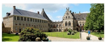
Bad Bentheim is a town in Lower Saxony. In Bad Bentheim is also found the castle Burg Bentheim ![]() , the town’s emblem.
, the town’s emblem.
Sightseeing
The town’s most prominent emblem, the castle – Burg Bentheim – stands in the town’s centre where it simply cannot be overlooked. The popular tourist site can be visited nowadays as a museum, with or without a guide. The high keep, known as the Pulverturm, or “Powder Tower”, affords visitors a good view over Bad Bentheim.
The Bad Bentheim Sandstone Museum (Bad Bentheimer Sandsteinmuseum) is a museum housed in an historic Bentheim farmer’s townhouse (the farmer in this case was an Ackerbürger, who lived in town and had a townsman’s rights, unlike many farmers) with additions, which shows the history of Bentheim sandstone (quarrying and use, trade and work) and the stone’s geology. Exhibits like, for instance, Romanesque baptismal fonts from the 12th and 13th centuries or fossils, to mention the two permanent exhibits, may be seen here.
The Franzosenschlucht (“Frenchman’s Gorge”) is found right next to the open-air theatre, the so-called Bentheimer Freilichtbühne (open-air stage). The Bad Bentheim open-air plays have an unusual venue set in three disused quarries, thereby offering an extraordinary natural backdrop. In summer plays are staged here. Often special events are held here such as nighttime performances.
The Haus Westerhoff is said to be one of the town’s loveliest farmer’s townhouses (Ackerbürgerhäuser), with its beginnings in 1656. Between 1989 and 1991, it was professionally restored. Today, artists and craftsmen display their works there.
Also worth seeing is the Reformed Protestant church with its Calvinistic interior décor, within which, among others, Count Arnold II zu Bentheim-Tecklenburg lies buried. It was built in 1696 on the site of the former early Gothic church from 1321, of which only bits are now maintained, such as a Gothic room and the Count’s crypt that lies thereunder. Today it is a plain Baroque church in the middle of which stands an old stone pulpit. In the graveyard around the church are found impressive, centuries-old gravestones of importance to art history.
The Roman Catholic Church of St. John the Baptist (Kirche St. Johannes Baptist) with its Baroque interior lies west of the Schlosspark and comes from the time of the Counterreformation. At Count Ernst Wilhelm’s behest, it was built in 1670 from Bentheim sandstone.
Outside, the building is rather plain, but inside there are stately, early Baroque altars and remains of the original glazing in the windows in the north wall.
Other sightseeing highlights include:
- evangelisch-altreformierte Kirche (church, 1896)
- Martin-Luther-Kirche (1912)
- Naturökologisch - Niederländisches Ferienreservat Gut Langen (holiday reserve)
- Bentheimer Wald (forest)
- Bentheimer Berge (mountains)
Information about copyright | |
|---|---|
Rights characteristic / license | by-sa: CREATIVE COMMONS Attribution-ShareAlike |
Link to the description of the license | |
Input taken over from: |
Wikipedia contributors, 'Bad Bentheim', Wikipedia, The Free Encyclopedia, 2 October 2014, 13:24 UTC, <http://en.wikipedia.org/w/index.php?title=Bad_Bentheim&oldid=627950491> [accessed 16 October 2014] |
taken over / edited on | 16 Oct 2014
|
taken over / edited by |
|
13 km
0,5 km
47 m
13 km
0,9 km
67 m
![]()