
Cycle Route Wikinger-Friesen-Weg (Süd)
Actions
![]()
Please wait - map data are loading
Added on 21 Nov 2020,
last edited by biroto-Redaktion on 24 Nov 2023
Actions
Cycle route metrics
Total distance in km
175
Information about rights to the gps-track data | |
|---|---|
Rights owner | OpenStreetMap and Contributors + biroto-Redaktion (biroto.eu) |
Rights characteristic / license | Contains information from OpenStreetMap, which is made available here under the Open Database License(ODbL) |
Link to the description of the license | |
GPX file taken from | |
GPX file uploaded | by biroto-Redaktion on 24 Nov 2023
|
Track points in total
2.670
Track points per km (avg)
15
Start/endpoint
Start location
Sankt Peter-Ording, SH, DE (4 m NHN)
End location
Maasholm, SH, DE (0 m NHN)
Signposting
|

Beds4Cyclists, worth visiting and infrastructure
Name and address
Latitude / Longitude
Phone
Fax
Mobile
Type of accommodation
Rating for cyclists
Route km
Dist. to route
Elevation
0 km
0,2 km
6 m
33 km
0,3 km
7 m
33 km
0,3 km
11 m
35 km
5,0 km
5 m
38 km
0,6 km
8 m
Information about copyright | |
|---|---|
Rights owner | |
Rights characteristic / license | by-sa: CREATIVE COMMONS Attribution-ShareAlike |
Link to the description of the license | |
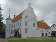
Image taken over from | https://commons.wikimedia.org/wiki/File:Hoyerswort_Herrenhaus.jpg |
Image has been uploaded | by biroto-Redaktion on 30 Dec 2018
|
In Oldenswort befindet sich Eiderstedts einziges Herrenhaus, Hoyerswort. Es handelt sich um einen zweiflügeligen Bau der Renaissance mit einem Treppenturm, der von einem doppelten Wassergraben umgeben ist. Im 16. Jahrhundert wurde es vom königlich dänischen Staller (Statthalter) Caspar Hoyer gebaut, von dem es auch seinen Namen hat.[6] Seine Schwiegertochter Anna Ovena Hoyer versammelte dort eine von den Ortsgeistlichen als häretisch angesehene Gemeinde. 1632 verkaufte sie das Herrenhaus an Augusta von Dänemark, die Witwe des Herzogs Johann Adolf. In der Folgezeit wechselte das Haus mehrfach den Besitzer, so gehörte es 1656–1679 dem herzoglichen Kammerrat Andreas Cramer. 1713 nahm dort der dänische König Friedrich IV. die Kapitulation der in der Festung Tönning stationierten schwedischen Truppen unter Magnus Stenbock im Großen Nordischen Krieg entgegen, womit der Krieg faktisch entschieden war. Das Gut gelangte nach wechselnden Eigentümern im Jahr 1771 in das Eigentum der Familie Hamkens, in dem es bis zum Jahr 2013 verblieb.
Das Museum
- Historie des Herrenhauses
- Leben und Wirken des berühmten Stallers Caspar Hoyer
- Dichterin und Sektiererin Anna Owena Hoyer
- Die in der Nähe gelegene Tofting-Warft
- Sieg der Friesen über den dänischen König Abel 1252 auf dem Königskamp bei Hoyerswort
- Kapitulation schwedischer Truppen in Tönning 1713 gegenüber dem dänischen König Friedrich IV. auf Hoyerswort
Information about copyright | |
|---|---|
Rights characteristic / license | by-sa: CREATIVE COMMONS Attribution-ShareAlike |
Link to the description of the license | |
Input taken over from: |
Seite „Oldenswort“. In: Wikipedia, Die freie Enzyklopädie. Bearbeitungsstand: 20. Dezember 2018, 14:41 UTC. URL: https://de.wikipedia.org/w/index.php?title=Oldenswort&oldid=183878319 (Abgerufen: 30. Dezember 2018, 12:27 UTC) |
taken over / edited on | 30 Dec 2018
|
taken over / edited by |
|
![]()