
Cycle Route EuroVelo: Mediterranean Route Greece new routing
No. of cycle route EV8
Actions
![]()
Please wait - map data are loading
Added on 02 Nov 2014,
last edited by biroto-Redaktion on 12 Jan 2021
Actions
Cycle route metrics
Total distance in km
660
Information about rights to the gps-track data | |
|---|---|
Rights owner | OpenStreetMap and Contributors + biroto-Redaktion (biroto.eu) |
Rights characteristic / license | Contains information from OpenStreetMap, which is made available here under the Open Database License(ODbL) |
Link to the description of the license | |
GPX file taken from | |
GPX file uploaded | by biroto-Redaktion on 12 Jan 2021
|
Track points in total
9.887
Track points per km (avg)
15
Start/endpoint
Start location
Athens, Attica, GR (69 m NHN)
End location
Sagiada, Epirus - Western Macedonia, GR (115 m NHN)
Remarks
Diese Route ist Teil der EuroVelo Route 8 "Mittelmeer-Route".
Beds4Cyclists, worth visiting and infrastructure
Name and address
Latitude / Longitude
Phone
Fax
Mobile
Type of accommodation
Rating for cyclists
Route km
Dist. to route
Elevation
94 km
0,3 km
8 m
Information about copyright | |
|---|---|
Rights owner | |
Rights characteristic / license | cc0: Public Domain no Rights reserved |
Link to the description of the license | |
Image taken over from | |
Image has been uploaded | by biroto-Redaktion on 03 Nov 2014
|
Information about copyright | |
|---|---|
Rights owner | |
Rights characteristic / license | by-sa: CREATIVE COMMONS Attribution-ShareAlike |
Link to the description of the license | |
Image taken over from | |
Image has been uploaded | by biroto-Redaktion on 03 Nov 2014
|
Information about copyright | |
|---|---|
Rights owner | |
Rights characteristic / license | by-sa: CREATIVE COMMONS Attribution-ShareAlike |
Link to the description of the license | |
Image taken over from | |
Image has been uploaded | by biroto-Redaktion on 03 Nov 2014
|
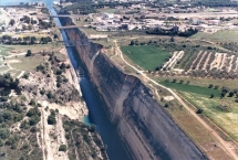
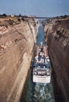
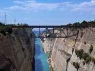
The Corinth Canal (Greek: Διώρυγα της Κορίνθου, Dhioryga tis Korinthou) is a canal that connects the Gulf of Corinth with the Saronic Gulf in the Aegean Sea. It cuts through the narrow Isthmus of Corinth and separates the Peloponnese from the Greek mainland, thus effectively making the former peninsula an island. The builders dug the canal through the Isthmus at sea level; no locks are employed. It is 6.4 kilometres (4.0 mi) in length and only 21.4 metres (70 ft) wide at its base, making it impassable for most modern ships. It now has little economic importance.
The canal was mooted in classical times and an abortive effort was made to build it in the 1st century AD. Construction finally got underway in 1881 but was hampered by geological and financial problems that bankrupted the original builders. It was completed in 1893, but due to the canal's narrowness, navigational problems and periodic closures to repair landslides from its steep walls, it failed to attract the level of traffic anticipated by its operators. It is now used mainly for tourist traffic.
The canal consists of a single channel 8 metres (26 ft) deep, excavated at sea level (thus requiring no locks), measuring 6,346 metres (20,820 ft) long by 24.6 metres (81 ft) wide at the top and 21.3 metres (70 ft) wide at the bottom. The rock walls, which rise 90 metres (300 ft) above sea level, are at a near-vertical 80° angle. The canal is crossed by a railway line, a road and a motorway at a height of about 45 metres (148 ft). In 1988 submersible bridges were installed at sea level at each end of the canal, by the eastern harbour of Isthmia and the western harbour of Poseidonia.
Although the canal saves the 700-kilometre (430 mi) journey around the Peloponnese, it is too narrow for modern ocean freighters, as it can only accommodate ships of a width of up to 16.5 metres (54 ft) and a draft of 7.3 metres (24 ft). Ships can only pass through the canal one at a time on a one-way system. Larger ships have to be towed by tugs. The canal is nowadays mostly used by tourist ships; 11,000 ships per year travel through the waterway.
Information about copyright | |
|---|---|
Rights characteristic / license | by-sa: CREATIVE COMMONS Attribution-ShareAlike |
Link to the description of the license | |
Input taken over from: |
Wikipedia contributors, 'Corinth Canal', Wikipedia, The Free Encyclopedia, 5 August 2014, 04:42 UTC, <http://en.wikipedia.org/w/index.php?title=Corinth_Canal&oldid=619914543> [accessed 2 November 2014] |
taken over / edited on | 03 Nov 2014
|
taken over / edited by |
|
234 km
0,0 km
5 m
Hours of opening
Hours of sailing (updated 31.08.2019)
- every 20 minutes from 07:00 to 23:00 from Rio and from Antirrio
- every 45 minutes from 23:00 to 7:00 from Rio and from Antirrio
236 km
0,4 km
0 m
Information about copyright | |
|---|---|
Rights owner | |
Rights characteristic / license | by-sa: CREATIVE COMMONS Attribution-ShareAlike |
Link to the description of the license | |
Image taken over from | |
Image has been uploaded | by biroto-Redaktion on 10 Oct 2014
|
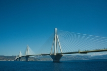
TheRio–Antirrio bridge (Greek: Γέφυρα Ρίου-Αντιρρίου), officially the Charilaos Trikoupis ![]() Bridge after the statesman who first envisaged it, is one of the world's longest multi-span cable-stayed bridges and the longest of the fully suspended type. It crosses the Gulf of Corinth near Patras
Bridge after the statesman who first envisaged it, is one of the world's longest multi-span cable-stayed bridges and the longest of the fully suspended type. It crosses the Gulf of Corinth near Patras ![]() , linking the town of Rio
, linking the town of Rio ![]() on the Peloponnese peninsula to Antirrio
on the Peloponnese peninsula to Antirrio ![]() on mainland Greece by road.
on mainland Greece by road.
The 2,880 m (9,449 ft) long bridge (approximately 1.8 miles) dramatically improves access to and from the Peloponnese, which could previously be reached only by ferry or via theisthmus of Corinth in the east. Its width is 28 m (92 ft) — it has two vehicle lanes per direction, an emergency lane and a pedestrian walkway. Its five-span four-pylon cable-stayed portion of length 2,252 m (7,388 ft) is the world's second longest cable-stayed deck; only the deck of the Millau Viaduct in southern France is longer at 2,460 m (8,071 ft). However, as the latter is also supported by bearings at the pylons apart from cable stays, the Rio–Antirrio bridge deck might be considered the longest cable-stayed "suspended" deck.
This bridge is widely considered to be an engineering masterpiece, owing to several solutions applied to span the difficult site. These difficulties include deep water, insecure materials for foundations, seismic activity, the probability of tsunamis, and the expansion of the Gulf of Corinth due to plate tectonics.
Information about copyright | |
|---|---|
Rights characteristic / license | by-sa: CREATIVE COMMONS Attribution-ShareAlike |
Link to the description of the license | |
Input taken over from: |
Wikipedia contributors, 'Rio–Antirrio bridge',Wikipedia, The Free Encyclopedia,27 September 2014, 12:17 UTC, <http://en.wikipedia.org/w/index.php?title=Rio%E2%80%93Antirrio_bridge&oldid=627271634> [accessed 9 October 2014] |
taken over / edited on | 10 Oct 2014
|
taken over / edited by |
|
237 km
0,6 km
0 m
Hours of opening
Hours of sailing (updated 31.08.2019)
- every 20 minutes from 07:00 to 23:00 from Rio and from Antirrio
- every 45 minutes from 23:00 to 7:00 from Rio and from Antirrio
455 km
2,5 km
62 m
Traditional guesthouse at Komboti
GR-47100 Municipality of N Skoufas-Komboti
Private/B&B
![]()