
Aida Cycle Route (Alta Italia da Attraversare)
No. of cycle route BI20
Actions
![]()
Please wait - map data are loading
Added on 21 Jul 2020,
last edited by biroto-Redaktion on 20 Oct 2023
Actions
Cycle route metrics
Total distance in km
934
Information about rights to the gps-track data | |
|---|---|
Rights owner | OpenStreetMap and Contributors + biroto-Redaktion (biroto.eu) |
Rights characteristic / license | Contains information from OpenStreetMap, which is made available here under the Open Database License(ODbL) |
Link to the description of the license | |
GPX file taken from | |
GPX file uploaded | by biroto-Redaktion on 20 Oct 2023
|
Track points in total
16.086
Track points per km (avg)
17
Start/endpoint
Start location
Moncenisio, 21, IT (1703 m NHN)
End location
Trieste, 36, IT (0 m NHN)
Beds4Cyclists, worth visiting and infrastructure
Name and address
Latitude / Longitude
Phone
Fax
Mobile
Type of accommodation
Rating for cyclists
Route km
Dist. to route
Elevation
26 km
0,8 km
496 m
Information about copyright | |
|---|---|
Rights owner | |
Rights characteristic / license | cc0: Public Domain no Rights reserved |
Link to the description of the license | |
Image taken over from | |
Image has been uploaded | by biroto-Redaktion on 04 Dec 2014
|
Information about copyright | |
|---|---|
Rights owner | |
Rights characteristic / license | by-sa: CREATIVE COMMONS Attribution-ShareAlike |
Link to the description of the license | |
Image taken over from | |
Image has been uploaded | by biroto-Redaktion on 04 Dec 2014
|
Information about copyright | |
|---|---|
Rights owner | |
Rights characteristic / license | by-sa: CREATIVE COMMONS Attribution-ShareAlike |
Link to the description of the license | |
Image taken over from | |
Image has been uploaded | by biroto-Redaktion on 04 Dec 2014
|
Information about copyright | |
|---|---|
Rights owner | |
Rights characteristic / license | by-sa: CREATIVE COMMONS Attribution-ShareAlike |
Link to the description of the license | |
Image taken over from | |
Image has been uploaded | by biroto-Redaktion on 04 Dec 2014
|
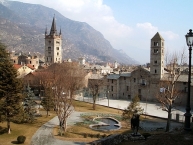
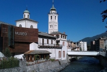
Susa (Latin: Segusio) is a city and comune in Piedmont, Italy. In the middle of Susa Valley ![]() , it is situated on at the confluence of the Cenischia
, it is situated on at the confluence of the Cenischia ![]() with the Dora Riparia
with the Dora Riparia ![]() , a tributary of the Po River, at the foot of the Cottian Alps, 51 km (32 mi) west of Turin.
, a tributary of the Po River, at the foot of the Cottian Alps, 51 km (32 mi) west of Turin.
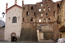
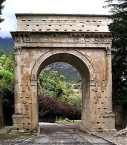
Main sights
- Susa Cathedral
 (Italian: Cattedrale di San Giusto) (1029).
 - The triumphal Arch of Augustus , erected by a Romanized Sugusian chief to Augustus in 8 BC.
- The Roman Amphitheater.
- Castle of Marquise Adelaide .
- Archaeological area of Piazza Savoia.
Information about copyright | |
|---|---|
Rights characteristic / license | by-sa: CREATIVE COMMONS Attribution-ShareAlike |
Link to the description of the license | |
Input taken over from: |
Wikipedia contributors, 'Susa, Piedmont', Wikipedia, The Free Encyclopedia, 1 May 2014, 13:36 UTC, <http://en.wikipedia.org/w/index.php?title=Susa,_Piedmont&oldid=606623935> [accessed 4 December 2014] |
taken over / edited on | 04 Dec 2014
|
taken over / edited by |
|
26 km
0,5 km
494 m
Hours of opening
Monday-Saturday: 09.00-12.00 ; 15.00-18.00
Sunday: 09.00-13.00
53 km
0,7 km
887 m
Information about copyright | |
|---|---|
Rights owner | |
Rights characteristic / license | by-sa: CREATIVE COMMONS Attribution-ShareAlike |
Link to the description of the license | |
Image taken over from | |
Image has been uploaded | by biroto-Redaktion on 03 Dec 2014
|
Information about copyright | |
|---|---|
Rights owner | |
Rights characteristic / license | cc0: Public Domain no Rights reserved |
Link to the description of the license | |
Image taken over from | commons.wikimedia.org/wiki/File:Sacra_di_San_Michele_-_Corpo_centrale.jpg |
Image has been uploaded | by biroto-Redaktion on 03 Dec 2014
|
Information about copyright | |
|---|---|
Rights owner | |
Rights characteristic / license | by-sa: CREATIVE COMMONS Attribution-ShareAlike |
Link to the description of the license | |
Image taken over from | commons.wikimedia.org/wiki/File:Sacra_di_san_michele,_chiesa_abbaziale,_portale_03.JPG |
Image has been uploaded | by biroto-Redaktion on 03 Dec 2014
|
Information about copyright | |
|---|---|
Rights owner | |
Rights characteristic / license | by-sa: CREATIVE COMMONS Attribution-ShareAlike |
Link to the description of the license | |
Image taken over from | |
Image has been uploaded | by biroto-Redaktion on 03 Dec 2014
|
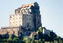
The Sacra di San Michele, sometimes known as Saint Michael's Abbey, is a religious complex on Mount Pirchiriano, situated on the south side of the Val di Susa ![]() overlooking the villages of Avigliana
overlooking the villages of Avigliana ![]() and Chiusa di San Michele
and Chiusa di San Michele ![]() , northern Italy. The abbey, which for much of its history came under Benedictine rule, is now entrusted to the Rosminians. A special regional law acknowledges it as the "Symbolic monument of the Piedmont region". The book The Name of the Rose was inspired by this monumental abbey.
, northern Italy. The abbey, which for much of its history came under Benedictine rule, is now entrusted to the Rosminians. A special regional law acknowledges it as the "Symbolic monument of the Piedmont region". The book The Name of the Rose was inspired by this monumental abbey.
Little is known of the early years of the abbey. The oldest extant account is that of a monk, William, who lived here in the late 11th century and wrote a Chronicon Coenobii Sancti Michaelis de Clusa. He sets the foundation of the abbey in 966, but, in another passage, the same monk maintains that the construction began under the pontificate of Sylvester II (999-1003).
What is certain is that what is now the crypt was built in the late 10th century, as attested by the Byzantine influence in the niches, columns and arches. According to tradition, this building was constructed by the hermit Saint Giovanni Vincenzo at the behest of the archangel Michael to whom he was particularly devoted; and the building materials which the hermit had collected were transported miraculously to the top of the mountain.
In the following years a small edifice was added, which could house a small community of monks and some pilgrims.
Later the abbey developed under the Benedictine rule, with the construction of a separate building with guest-rooms for pilgrims following the popular Via Francigena ![]() and of a church-monastery (1015–1035), probably on the remains of the ancient Roman castrum.
and of a church-monastery (1015–1035), probably on the remains of the ancient Roman castrum.
Abbot Ermengardo (1099–1131) had a new large, 26 m-high basement built from the foot of the hill to its peak, on which a new church (the one still existing today) was added, including the surrounding structures.
The monastery fell into decline and was finally suppressed in 1622 by Pope Gregory XV. It remained abandoned until 1835, when King Charles Albert and the Pope asked Antonio Rosmini to restore and repopulate it. It is currently under the care Rosminians.
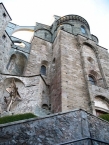
Art and architecture
The church, whose construction lasted for many years, is characterized by the unusual position of the façade, which is at a lower level than the floor of the church's interior.
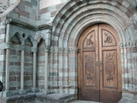
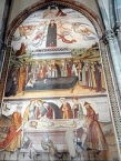
The 41 m-high façade gives access to the Scalone del Morti ("Stairway of the Dead"), flanked by arches, niches and tombs in which, until recent times, skeletons of dead monks where visible (hence the name). At the top of the steps is the marble Porta dello Zodiaco, a masterwork of 12th century sculpture. The church itself is accessed by a Romanesque portal in grey and green stone, built in the early 11th century. The church has a nave and two aisles, and features elements from both the Gothic and Romanesque styles of architecture. On the left wall is a large fresco portraying the Annunciation (1505), while in the Old Choir is a triptych by Defendente Ferrari.
The complex includes the ruins of the 12th-15th centuries monastery, which had five floors. It ends with the Torre della Bell'Alda ("Tower of the Beautiful Alda") The so-called "Monks' Sepulchre" is probably the remains of a chapel reproducing, in its octagonal plan, the Holy Sepulchre of Jerusalem.
Information about copyright | |
|---|---|
Rights characteristic / license | by-sa: CREATIVE COMMONS Attribution-ShareAlike |
Link to the description of the license | |
Input taken over from: |
Wikipedia contributors, 'Sacra di San Michele', Wikipedia, The Free Encyclopedia, 31 March 2014, 18:05 UTC, <http://en.wikipedia.org/w/index.php?title=Sacra_di_San_Michele&oldid=602143287> [accessed 3 December 2014] |
taken over / edited on | 03 Dec 2014
|
taken over / edited by |
|
Hours of opening
Winter timetable from October 16 to March 15
- Weekdays: 9.30-12.30, 14.30-17.00;
- Sundays and public holidays: 9.30-12.00, 14.30-17.30;
Summer timetable from March 16 to October 15
- Weekdays: 9.30-12.30, 14.30-18.00;
- Sundays and public olidays: 9.30-12.00, 14.30-18.30;
The last entry is allowed 30 minutes before closing
Closing day:
Monday, except public holidays
91 km
0,5 km
236 m
Information about copyright | |
|---|---|
Rights owner | |
Rights characteristic / license | by-sa: CREATIVE COMMONS Attribution-ShareAlike |
Link to the description of the license | |
Image taken over from | en.wikipedia.org/wiki/File:Palazzina_di_caccia_di_Stupinigi1.JPG |
Image has been uploaded | by biroto-Redaktion on 03 Dec 2014
|
Information about copyright | |
|---|---|
Rights owner | |
Rights characteristic / license | by-sa: CREATIVE COMMONS Attribution-ShareAlike |
Link to the description of the license | |
Image taken over from | commons.wikimedia.org/wiki/File:Stupinigi_centrale_hal_boven.jpg |
Image has been uploaded | by biroto-Redaktion on 03 Dec 2014
|
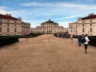
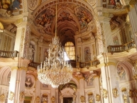
The Palazzina di caccia of Stupinigi (Italian: "The hunting residence of Stupinigi") is one of the Residences of the Royal House of Savoy in northern Italy, part of the UNESCO World Heritage Sites list. Built as a royal hunting lodge in the early 18th century, it is located in Stupinigi ![]() , a suburb of the town of Nichelino
, a suburb of the town of Nichelino ![]() , 10 km (6 mi) southwest of Turin
, 10 km (6 mi) southwest of Turin ![]() .
.
The original castle was owned by the Acaja line of the House of Savoy, Lords of Piedmont until 1418, and was sold to marquis Rolando Pallavicino in 1493. It was then acquired by Emmanuel Philibert in 1563, when the ducal capital was moved from Chambéry to Turin.
The new palace was designed by the architect Filippo Juvarra to be used as a palazzina di caccia ("hunting lodge") for Victor Amadeus II, King of Sardinia. Works started in 1729. Within two years construction was far enough advanced for the first formal hunt to take place.
Juvarra called upon a team of decorators, many of them from Venice, to carry out the decor of the palazzina interiors. In the reigns of Carlo Emanuele III and Victor Amadeus III the palazzina and its formal park continued to be extended, at first by Juvarra's assistant, Giovanni Tommaso Prunotto, then by numerous North Italian architects. The final building has a total of 137 rooms and 17 galleries, and covers 31,050 square meters [1]. Polissena of Hesse-Rotenburg, wife of Carlo Emanuele III also carried out improvements.
The original purpose of the hunting lodge is symbolized by the bronze stag perched at the apex of the stepped roof of its central dome, and the hounds' heads that decorate the vases on the roofline. The building has a saltire plan: four angled wings project from the oval-shaped main hall.
The extensions resulted in separate pavilions linked by long angled galleries and a long octagonal forecourt enclosed by wings, extended forwards in two further entrance courts.
Stupinigi was the preferred building to be used for celebrations and dynastic weddings by members of the House of Savoy. Here, in 1773, Maria Teresa, Princess of Savoy, married Charles Philippe, Count of Artois, brother of Louis XVI and the future Charles X of France.
Today the Palace of Stupinigi houses the Museo di Arte e Ammobiliamento, a museum of the arts and furnishings, some original to the palazzina, others brought from the former Savoia residences of Moncalieri and Venaria Reale. Stupinigi has the most important collection of Piedmontese furniture, including works by Turin's three most famous Royal cabinet-makers, Giuseppe Maria Bonzanigo, Pietro Piffetti and Luigi Prinotti. Some of the sculptures of hunting figures are by Giovanni Battista Bernero. Additionally, temporary exhibitions are held in its galleries, such as the Mostra del Barocco (1963).
Information about copyright | |
|---|---|
Rights characteristic / license | by-sa: CREATIVE COMMONS Attribution-ShareAlike |
Link to the description of the license | |
Input taken over from: |
Wikipedia contributors, 'Palazzina di caccia of Stupinigi', Wikipedia, The Free Encyclopedia, 20 July 2014, 03:50 UTC, <http://en.wikipedia.org/w/index.php?title=Palazzina_di_caccia_of_Stupinigi&oldid=617662284> [accessed 3 December 2014] |
taken over / edited on | 03 Dec 2014
|
taken over / edited by |
|
100 km
1,3 km
235 m
![]()