
Cycle Route Hanzeroute
No. of cycle route LF3
Actions
![]()
Please wait - map data are loading
Added on 24 Oct 2011,
on 17 Apr 2024
Actions
Cycle route metrics
Total distance in km
141
Information about rights to the gps-track data | |
|---|---|
Rights owner | OpenStreetMap and Contributors + biroto-Redaktion (biroto.eu) |
Rights characteristic / license | Contains information from OpenStreetMap, which is made available here under the Open Database License(ODbL) |
Link to the description of the license | |
GPX file taken from | |
GPX file uploaded | by biroto-Redaktion on 17 Apr 2024
|
Track points in total
2.550
Track points per km (avg)
18
Start/endpoint
Start location
Millingen aan de Rijn, Gelderland, NL (14 m NHN)
End location
Kampen, Overijssel, NL (0 m NHN)
Sources of information
Beds4Cyclists, worth visiting and infrastructure
Name and address
Latitude / Longitude
Phone
Fax
Mobile
Type of accommodation
Rating for cyclists
Route km
Dist. to route
Elevation
18 km
4,4 km
16 m
18 km
3,9 km
12 m
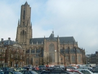
Arnhem (/ˈɑːnəm/ or /ˈɑːnhɛm/, Dutch: [ˈɑrnɛm] or [ˈɑrnhɛm], South Guelderish: Èrnem), is a city and municipality, situated in the eastern part of the Netherlands. It is the capital of the province of Gelderland. Arnhem had a population of 151,356 in 2014.
Places of interest
- The Groote Kerk (St. Eusebius), built 1452–1560, lost most of its tower during World War II, of which a part has been reconstructed to a modern design and opened in 1964. Officially the tower is not part of the church and is owned by the municipality.
- The house of Maarten van Rossum, a general serving Duke Charles van Gelre, has been the town hall since 1830: The satyrs in its Renaissance ornamentation earned it the name Duivelshuis ("devil's house").
- Burgers' Zoo
 is one of the biggest and most-visited zoos in the Netherlands, featuring an underwater walkthrough, desert, mangrove, rainforest, etc.
 - The Gelredome , the home field of Vitesse, the city's Eredivisie team in football, is a unique facility that features a retractable roof and a slide-out grass pitch.
- The KEMA Toren (formerly known as SEP Control Tower) is the highest structure of the town. It is a 140-m-high TV tower.
Information about copyright | |
|---|---|
Rights characteristic / license | by-sa: CREATIVE COMMONS Attribution-ShareAlike |
Link to the description of the license | |
Input taken over from: |
Wikipedia contributors, 'Arnhem', Wikipedia, The Free Encyclopedia, 6 October 2014, 12:40 UTC, <http://en.wikipedia.org/w/index.php?title=Arnhem&oldid=628469218> [accessed 16 October 2014] |
taken over / edited on | 16 Oct 2014
|
taken over / edited by |
|
35 km
0,2 km
10 m
Hours of opening
Monday to Saturday 10:30 - 15:30
1st Sunday of the month / Cultural Sunday 12:00 - 16:00
35 km
0,0 km
20 m
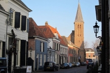
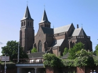
Doesburg is one of the seven Hanseatic cities along the river IJssel. It is located in the Dutch province of Gelderland.
Understand
Doesburg received its city rights in 1237. Its location by the merging point of the Oude IJssel and IJssel rivers made it a strategical city. Doesburg used to be the economic capital of the Doesburg Quarter, a sub-region of the Zutphen Quarter. The Martinichurch is one of the remains of the former wealth. The silting of the Oude IJssel in the fifteenth century, which blocked the access to the cities along the Oude IJssel, limited Doesburg its wealth due to a lack of trade.
Nowadays the city still has many old buildings. The banks of the city are being modernised, but the city centre is still mostly intact.
See
- ⊙Martinichurch, Kerkstraat 4, NL-6981 Doesburg, ☎ +31 313 475749.
- ⊙Museum De Roode Tooren (Regional Museum), Roggestraat 9, NL-6981 Doesburg, ☎ +31 313 474265.
- ⊙Doesburgsche Mosterd- en Azijnfabriek (Doesburgian Mustard and Vinegarfactory), Boekholtstraat 22, NL-6981 CW Doesburg, ☎ +31 313 472230.
- ⊙Société Musée Lalique Pays Bas, Gasthuisstraat 1, NL-6981 CP Doesburg, ☎ +31 313 471410.
- ⊙Doesburg Town Hall, Philippus Gastelaarsstraat 2, NL-6981 BH Doesburg.
Information about copyright | |
|---|---|
Rights characteristic / license | by-sa: CREATIVE COMMONS Attribution-ShareAlike |
Link to the description of the license | |
Input taken over from: |
Wikivoyagecontributors,'Doesburg',Wikivoyage,TheFREEworldwidetravelguidethatanyonecanedit,20August2017,15:16UTC, |
taken over / edited on | 06 Apr 2019
|
taken over / edited by |
|
60 km
0,0 km
9 m
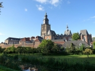
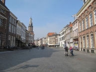
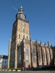
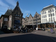
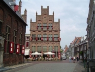
Zutphen (population 46,000) is an historic city in the center-eastern part of the Netherlands. The city has existed since Roman times and received its city rights in 1190, making it one of the oldest medieval cities in the Netherlands.
The city was voted as having the best city center of The Netherlands in the category of small cities in 2006.
It has an untouched historic city center that gives you the feeling of travelling hundreds of years back in time. It is not widely known to foreign tourists and waiting to be discovered.
Understand
Zutphen is located in a river valley at the river IJssel, a sidebranch from the branch of the Rhine known as the Nederrijn. The small river Berkel (no shipping possible) as well as the major Twentekanaal (channel) flow into the IJssel near Zutphen. The city lies at the border of the hilly forested Veluwe region and the more flat and agricultural Achterhoek.
See
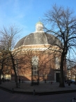
Its Dutch tourist promotion slogan, "Torenstad", means "Tower-city", which refers to the large number of towers. The largest is the Walburgkerk (officially it's called "St. Walburgiskerk", but the locals say "Walburgkerk"), located at the square where the city originated. Guided tours are available, organized by the VVV located directly opposite the railway station. These tours will also allow you to visit the medieval library "Librije" - books have been kept here secure since the 1600s by chaining them to the desks.
- ⊙'s Gravenhof, Kerkhof 3, ☎ +31 575 547058. Containing both the Walburgiskerk, locally known as 'Walburgkerk', one of the biggest churches in the country, as well as the old city hall, the 's Gravenhof is the place where the city was founded and grew around, filled with both modern and classical buildings. (updated Jul 2017)
- ⊙City museum, 's Gravenhof 4, ☎ +31 575 516878. (updated Jul 2017)
- ⊙Berkelpoort, Isendoornstraat 21. The Berkelpoort is one of the old gates of the city, spanning the Berkel river.
- ⊙Broederenkerk. Fourteenth-century monasterium on the outskirts of the old walled city.
Information about copyright | |
|---|---|
Rights characteristic / license | by-sa: CREATIVE COMMONS Attribution-ShareAlike |
Link to the description of the license | |
Input taken over from: |
Wikivoyage contributors, 'Zutphen', Wikivoyage, The FREE worldwide travel guide that anyone can edit, 13 January 2019, 07:24 UTC, https://en.wikivoyage.org/w/index.php?title=Zutphen&oldid=3691776 [accessed 6 April 2019] |
taken over / edited on | 06 Apr 2019
|
taken over / edited by |
|
![]()