Radweg Küstenroute Nordkap-Trondheim
Nr. des Radweges 1C
Aktionen
![]()
Bitte warten - Kartendaten werden geladen
Erstellt am 27.12.2011,
zuletzt geändert von biroto-Redaktion am 04.11.2023
Aktionen
Strecken-Merkmale
Gesamtlänge in km
1.872
Informationen zu Rechten an den GPS-Track-Daten | |
|---|---|
Rechte-Inhaber | OpenStreetMap and Contributors + biroto-Redaktion (biroto.eu) |
Rechte-Ausprägung / Lizenz | Enthält Daten von OpenStreetMap, die hier unter der Open Database License(ODbL) verfügbar gemacht werden |
Link zur Rechtebeschreibung | |
gpx-Datei übernommen aus | |
gpx-Datei hochgeladen | durch biroto-Redaktion am 04.11.2023
|
Gesamtzahl Trackpoints
28.988
Trackpoint-Dichte per km
14
Endorte
Start
Skarsvåg, NO (306 m NHN)
Ziel
Trondheim, NO (15 m NHN)
Fahrradfreundliche Unterkünfte, Sehenswertes und Infrastruktur
Name u. Anschrift
Breite / Länge
Tel.
Fax.
Mobile
Art d. Unterkunft
Radler-freund-lichkeit
Strecken-km
km zur Strecke
Höhe
83 km
1,5 km
1 m
1.216 km
0,3 km
10 m
Öffnungszeiten
June - August:
Monday-Friday: 09.00-20.00
Saturday: 10.00-18.00
Sunday: 10.00-18.00
Opening hours rest of the year: Monday-Friday 09.00-15.30
1.217 km
0,4 km
5 m
Informationen zu Urheber-Rechten | |
|---|---|
Rechte-Inhaber | |
Rechte-Ausprägung / Lizenz | by-sa: CREATIVE COMMONS Namensnennung, Weitergabe unter gleichen Bedingungen |
Link zur Rechtebeschreibung | |
Bild übernommen aus | https://commons.wikimedia.org/wiki/File:Bodø_Cathedral,_South_view_20150608_1.jpg |
Bild hochgeladen | durch biroto-Redaktion am 26.12.2018
|
Informationen zu Urheber-Rechten | |
|---|---|
Rechte-Inhaber | |
Rechte-Ausprägung / Lizenz | by-sa: CREATIVE COMMONS Namensnennung, Weitergabe unter gleichen Bedingungen |
Link zur Rechtebeschreibung | |
Bild übernommen aus | |
Bild hochgeladen | durch biroto-Redaktion am 26.12.2018
|
Bodø is the seat of Nordland county in Norway. With 50 000 citizens, it is the second largest city in Northern Norway. Bodø is located on a peninsula facing the open sea, and infamously windy.
It is a gateway to the Arctic, being the northern end station of the Norwegian railway network (except the short connection from Narvik to Sweden), and an important ferry station.
Understand
In the Viking Age, the province was known as Hålogaland, and famous for shipmaking. In 1663, Bodø was mentioned as a village with postal service. In the 19th century, fish canning became an important industry for Bodø, and made the city grow. As Nazi Germany invaded Norway in 1940, they bombed Bodø on May 27, destroying most buildings. The city was rebuilt after the war, and therefore looks remarkably modern.
In 1960, the American spy plane U-2 heading for Bodø was shot down by the Soviet Union, and Soviet leader Nikita Chrushchev threatened to bomb Bodø.
Bodø has a university, and a young and rapidly growing population.
See and do
Museums
- ⊙Norwegian Aviation Museum (Norsk Luftfartsmuseum), Olav V gate. Located in the shopping centre area, a 20-minute walk from the city centre, you can visit a quite large museum and experience the history of aviation and highlights from the Cold War. Bodø is one of the airfields used for U-2 high-altitude recon and ozone monitoring.
- ⊙Bodø friluftsmuseum (Bodø open air museum) (South of the Bodø camping). Open 24h. The inside of the houses can only be visited by appointment. Various traditional house styles from Bodø. Free.
- Kjerringøy handelssted. Kjerringøy trading post is a 19th-century trade centre typical for Northern Norway. It's a museum, and you can get guided tours. Kjerringøy is a peninsula with beautiful scenery and many tourist activities. Busses from Bodø
Churches
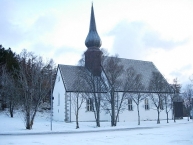
- ⊙Bodø Cathedral (Bodø domkirke), Torvgata 12. Modern with a separate bell-tower and a beautiful window.
- ⊙Bodin Kirke (Bodin Church) (In the South part of Bodø). One of the oldest churches in Norway, built around 1240. Free entrance.
Informationen zu Urheber-Rechten | |
|---|---|
Rechte-Ausprägung / Lizenz | by-sa: CREATIVE COMMONS Namensnennung, Weitergabe unter gleichen Bedingungen |
Link zur Rechtebeschreibung | |
Text(e) übernommen von: |
Wikivoyage contributors, 'Bodø', Wikivoyage, The FREE worldwide travel guide that anyone can edit, 30 September 2018, 14:07 UTC, <https://en.wikivoyage.org/w/index.php?title=Bod%C3%B8&oldid=3620444> [accessed 26 December 2018] |
übernommen / bearbeitet am | 26.12.2018
|
übernommen / bearbeitet durch |
|
1.247 km
0,2 km
0 m
Informationen zu Urheber-Rechten | |
|---|---|
Rechte-Inhaber | |
Rechte-Ausprägung / Lizenz | by-sa: CREATIVE COMMONS Namensnennung, Weitergabe unter gleichen Bedingungen |
Link zur Rechtebeschreibung | |
Bild übernommen aus | https://commons.wikimedia.org/wiki/File:Apparent_whirlpools_of_Saltstraumen_seen_from_the_air.jpg |
Bild hochgeladen | durch biroto-Redaktion am 26.12.2018
|
Informationen zu Urheber-Rechten | |
|---|---|
Rechte-Inhaber | |
Rechte-Ausprägung / Lizenz | by-sa: CREATIVE COMMONS Namensnennung, Weitergabe unter gleichen Bedingungen |
Link zur Rechtebeschreibung | |
Bild übernommen aus | https://commons.wikimedia.org/wiki/File:Saltstraumen_flickr.jpg |
Bild hochgeladen | durch biroto-Redaktion am 26.12.2018
|
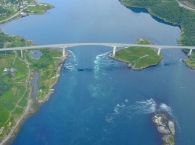
Der Saltstraumen, 30 Straßenkilometer (Luftlinie etwa 10 Kilometer) südöstlich der Stadt Bodø in Norwegen gelegen, ist der stärkste Gezeitenstrom der Welt. Sein Name leitet sich ab von Salten
, der Region in der er sich befindet. Straumen ist Nynorsk für „Strom, Strömung“.
Durch einen 2,5 Kilometer langen und etwa 150 Meter breiten Sund strömen im Wechsel der Gezeiten fast 400 Millionen Kubikmeter Wasser zwischen dem Saltfjord am Meer und dem Skjerstadfjord im Inland (auch „Innerer Saltfjord“) hin und her. Der Sund befindet sich zwischen der Insel Straumøy im Süden und der Halbinsel Knaplundsoya im Norden. Der Wasserstrom durch die Engstelle zwischen Straumøya und dem Festland ist wegen geringer Wassertiefe klein.
Der Strom erreicht dabei Geschwindigkeiten von bis zu 40 km/h, an seinem Rand entstehen gewaltige Strudel. Sie können einen Durchmesser bis zu zehn Metern erreichen und mehr als vier Meter in die Tiefe reichen. Lediglich bei Stillwasser, also beim Höchst- und Tiefststand, tritt für kurze Zeit Ruhe ein. Auf einer Brücke führt die Küstenstraße Fv17 über den Strom und bietet eindrucksvolle Aussichten. Die Ufer des Saltstraumen bieten begehrte Angelplätze, da das nährstoffreiche Wasser Fische anzieht. So wurde hier ein Weltrekord-Seelachs gefangen, der 22,7 Kilogramm wog.
In der Sommersaison informiert das Saltstraumen Museum, Ripnesveien, mittwochs und am Wochenende über Lokal- und Naturgeschichte.
Informationen zu Urheber-Rechten | |
|---|---|
Rechte-Ausprägung / Lizenz | by-sa: CREATIVE COMMONS Namensnennung, Weitergabe unter gleichen Bedingungen |
Link zur Rechtebeschreibung | |
Text(e) übernommen von: |
Seite „Saltstraumen“. In: Wikipedia, Die freie Enzyklopädie. Bearbeitungsstand: 15. Dezember 2018, 12:17 UTC. URL: https://de.wikipedia.org/w/index.php?title=Saltstraumen&oldid=183724884 (Abgerufen: 26. Dezember 2018, 10:21 UTC) |
übernommen / bearbeitet am | 26.12.2018
|
übernommen / bearbeitet durch |
|
1.553 km
0,7 km
14 m
Öffnungszeiten
20 of June to 14 of August:
Monday-Friday 9 am to 7 pm
Saturday and Sunday 11 am to 5 pm
20 of June to 5 of August:
from 9 am to 7 pm.)
15 of August to 31 of August:
Monday - Friday 10 am to 4 pm
Saturday and Sunday Closed
![]()


