
Cycle Route Sognefjellsvegen - Røros-Bergen
No. of cycle route 6
Actions
![]()
Please wait - map data are loading
Added on 27 Dec 2011,
last edited by biroto-Redaktion on 17 Oct 2023
Actions
Cycle route metrics
Total distance in km
722
Information about rights to the gps-track data | |
|---|---|
Rights owner | |
Rights characteristic / license | cc0: Public Domain no Rights reserved |
Link to the description of the license | |
GPX file uploaded | by biroto-Redaktion on 17 Oct 2023
|
Track points in total
15.782
Track points per km (avg)
21
Start/endpoint
Start location
Røros, NO (628 m NHN)
End location
Bergen, NO (19 m NHN)
Signposting
|
|

Remarks
Between Stanghelle and Trengereid it is recommended to take the train to avoid the tunnels.
Beds4Cyclists, worth visiting and infrastructure
Name and address
Latitude / Longitude
Phone
Fax
Mobile
Type of accommodation
Rating for cyclists
Route km
Dist. to route
Elevation
322 km
0,0 km
381 m
Hours of opening
29 May – 18 June: 10:00 am – 6:00 pm
19 June – 17 August:
Week days: 09:00 am – 9:00 pm
Saturdays: 09:00 am – 6:00 pm
Sundays: 11:00 am – 6:00 pm
18 August – 30 August: 10:00 (11:00) am – 6:00 pm
369 km
0,0 km
1.253 m
433 km
0,4 km
103 m
Information about copyright | |
|---|---|
Rights owner | |
Rights characteristic / license | cc0: Public Domain no Rights reserved |
Link to the description of the license | |
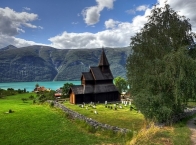
Image taken over from | https://commons.wikimedia.org/wiki/File:Stave_church_Urnes_-_Panorama_HDR_cropped.jpg |
Image has been uploaded | by biroto-Redaktion on 26 Dec 2018
|
Information about copyright | |
|---|---|
Rights owner | |
Rights characteristic / license | by-sa: CREATIVE COMMONS Attribution-ShareAlike |
Link to the description of the license | |
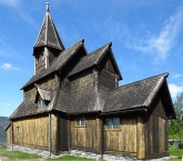
Image taken over from | https://commons.wikimedia.org/wiki/File:Stabkirche_Urnes.JPG |
Image has been uploaded | by biroto-Redaktion on 26 Dec 2018
|
Information about copyright | |
|---|---|
Rights owner | https://commons.wikimedia.org/w/index.php?title=User:Sirildl |
Rights characteristic / license | by-sa: CREATIVE COMMONS Attribution-ShareAlike |
Link to the description of the license | |
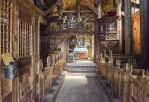
Image taken over from | https://commons.wikimedia.org/wiki/File:Urnes_stavkyrkje_85729_03.jpg |
Image has been uploaded | by biroto-Redaktion on 26 Dec 2018
|
Urnes Stave Church (Norwegian: Urnes stavkyrkje) is a 12th-century stave church at Ornes ![]() , along the Lustrafjorden
, along the Lustrafjorden ![]() in the municipality of Luster in Sogn og Fjordane county, Norway. It sits on the eastern side of the fjord, directly across the fjord from the village of Solvorn
in the municipality of Luster in Sogn og Fjordane county, Norway. It sits on the eastern side of the fjord, directly across the fjord from the village of Solvorn ![]() and about 5 kilometres (3.1 mi) east of the village of Hafslo
and about 5 kilometres (3.1 mi) east of the village of Hafslo ![]() .
.
It has been owned by Fortidsminneforeningen (Society for the Preservation of Norwegian Ancient Monuments) since 1881. In 1979, the Urnes Stave Church was listed as a World Heritage Site by UNESCO.
History
The church was built around 1130 or shortly thereafter, and still stands in its original location; it is believed to be the oldest of its kind. It provides a link between Christian architecture and the architecture and artforms of the Viking Age with typical animal-ornamentation, the so-called "Urnes style" of animal-art.
The church has not been in ordinary use since 1881, when the parish of Urnes was abolished, and it became a part of Solvorn parish in the Indre Sogn deanery of the Diocese of Bjørgvin. It is now only used for special occasions in the parish such as baptisms and weddings.
Present building
The church is built with a rectangular nave and a narrower choir. The nave and choir both have raised central spaces. The choir was extended to the east in the 17th century, but this addition was later removed. The drawing by Johan Christian Dahl depicts this, as well as the deteriorated state of the church at that time. During the 20th century the church underwent a restoration, and the richly decorated wall planks were covered to stop further deterioration.
A large number of medieval constructive elements remain in situ: ground beams (grunnstokker), sills (sviller), corner posts (hjørnestolper), wall planks (veggtiler) and aisle wall plates (stavlægjer). The construction of the raised central area with staves, strings and cross braces, and the roof itself, also date from medieval times.
From the previous church on the site remain, in addition to the portal, two wall planks in the northern wall, the corner post of the choir, the western gable of the nave and the eastern gable of the choir.
Information about copyright | |
|---|---|
Rights characteristic / license | by-sa: CREATIVE COMMONS Attribution-ShareAlike |
Link to the description of the license | |
Input taken over from: |
Wikipedia contributors, 'Urnes Stave Church', Wikipedia, The Free Encyclopedia, 25 December 2018, 04:43 UTC, <https://en.wikipedia.org/w/index.php?title=Urnes_Stave_Church&oldid=875275824> [accessed 26 December 2018] |
taken over / edited on | 26 Dec 2018
|
taken over / edited by |
|
Hours of opening
May to September
The church is open from 10:30 to 17.45 every day
685 km
0,0 km
14 m
719 km
0,1 km
12 m
![]()