
European Cycle Route R1 Poland - Gronowo-Küstrin
No. of cycle route R1
Actions
![]()
Please wait - map data are loading
Added on 05 Oct 2011,
last edited by biroto-Redaktion on 02 Jan 2021
Actions
Cycle route metrics
Total distance in km
636
Information about rights to the gps-track data | |
|---|---|
Rights owner | OpenStreetMap and Contributors + biroto-Redaktion (biroto.eu) |
Rights characteristic / license | Contains information from OpenStreetMap, which is made available here under the Open Database License(ODbL) |
Link to the description of the license | |
GPX file taken from | |
GPX file uploaded | by biroto-Redaktion on 02 Jan 2021
|
Track points in total
5.685
Track points per km (avg)
9
Start/endpoint
Start location
Küstriner Vorland, Brandenburg, DE (0 m NHN)
End location
Gronowo, Warmian-Masurian Voivodeship, PL (15 m NHN)
Sources of information
Portale:
- Offizielles Portal des Europaradweges R1
Beds4Cyclists, worth visiting and infrastructure
Name and address
Latitude / Longitude
Phone
Fax
Mobile
Type of accommodation
Rating for cyclists
Route km
Dist. to route
Elevation
1 km
1,3 km
23 m
1 km
1,1 km
17 m
Information about copyright | |
|---|---|
Rights owner | |
Rights characteristic / license | by-sa: CREATIVE COMMONS Attribution-ShareAlike |
Link to the description of the license | |
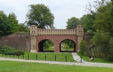
Image taken over from | commons.wikimedia.org/wiki/File:Festung_Küstrin_(Altstadt)_-_Berliner_Tor.jpg |
Image has been uploaded | by biroto-Redaktion on 13 Nov 2011
|
Information about copyright | |
|---|---|
Rights owner | |
Rights characteristic / license | by-sa: CREATIVE COMMONS Attribution-ShareAlike |
Link to the description of the license | |
Image taken over from | |
Image has been uploaded | by biroto-Redaktion on 13 Nov 2011
|
Kostrzyn nad Odrą (deutsch: Küstrin) ist eine Stadt in Polen in der Woiwodschaft Lebus an der Mündung der Warthe in die Oder. Westlich der Oder liegt die Gemeinde Küstriner Vorland im Bundesland Brandenburg, deren Ortsteil Küstrin-Kietz bis zur Grenzziehung entlang der Oder im Jahre 1945 mit dem heute polnischen Teil gemeinsam zur Festungsstadt Küstrin gehörte.
Hintergrund
Kostrzyn liegt an der Mündung der Warthe in die Oder an der Westgrenze Polens zu Deutschland, am nordwestlichen Eck des Warthemündung-Nationalpark (Ujście Warty).
Kosterin war zunächst eine Siedlung der slawischen Pomoranen, die ab dem 10. Jahrhundert phasenweise Polen tributpflichtig waren. Im 13. Jahrhundert wurde das spätere Küstrin den Tempelrittern übertragen, die hier einen Markt nach deutschem Recht errichten durften. 1261 fiel Küstrin mit dem bis dahin polnischen Land Lebus an die Mark Brandenburg, die diese Gegend als Neumark bezeichnete.
Von 1535 bis 1571 war Küstrin Residenzstadt einer eigenen Nebenlinie der brandenburgischen Hohenzollern. In dieser Zeit wurde das Schloss errichtet und Küstrin zur Festungsstadt ausgebaut. Im 17. Jahrhundert wurde diese zu einer der stärksten Festungen Deutschlands verstärkt. 1730 wurde Hans Hermann von Katte, der Freund des preußischen Kronprinzen Friedrich (später als Friedrich der Große bekannt) in Küstrin hingerichtet, mit dem zusammen der junge Thronfolge vor dem strengen Erziehungsregiment seines Vaters Friedrich Wilhelm I. (der „Soldatenkönig“) fliehen wollte. Friedrich musste bei der Enthauptung seines Freundes zusehen.
Nach dem Anschluß an die Eisenbahn siedelte sich in der zweiten Hälfte des 19. Jahrhunderts Industrie an. Nach dem Ersten Weltkrieg wurden die meisten militärischen Einrichtungen demontiert, Küstrin wurde aber während der Naziherrschaft wieder eine bedeutende Garnisonsstadt. In der Endphase des Zweiten Weltkriegs, im Januar/Februar 1945 wurde die Stadt massiv zerstört; Küstrin war eine der am stärksten zerstörten Städte Ostdeutschlands (ca. 90 % der Altstadt).
Nach 1945 kam der größere, östlich der Oder gelegene Teil des damaligen Küstrin an Polen, nur der Stadtteil Kietz verblieb bei Deutschland. Die deutsche Bevölkerung wurde größtenteils vertrieben. Die Trümmer der zerstörten Altstadt wurden weitgehend abtransportiert und für den Wiederaufbau Warschaus verwendet. Sie ist heute eine unbewohnte Wüstung. Stattdessen wurden komplett neue Stadtviertel weiter im Landesinneren errichtet, es gibt also kaum eine Kontinuität der Vorkriegsstadt.
Sehenswürdigkeiten
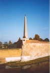
- Von der nach dem 2. Weltkrieg völlig zerstörten Altstadt/Festung sind die Grundmauern freigelegt worden. Ein Spaziergang durch die von der Vegetation teilweise überwucherten Ruinen der völlig verwüsteten Stadt kann verwunschen, bizarr aber auch unheimlich wirken. Manche sprechen von einem „Pompeji an der Oder.“
- Die Bastionen der Festung (König, Königin, Brandenburg und Philipp) sind teilweise erhalten.
- Museum Festung Küstrin (Muzeum Twierdzy Kostrzyn), in der Bastion Philipp, ul. Graniczna 1. ☎ +48 95 752 0045. Geöffnet: Mai–Oktober Di-Fr 11:00–14:00 Uhr (letzter Einlass 13:00), Sa-So 10:00–18:00 Uhr (letzter Einlass 17:00), im Winterhalbjahr nur nach Vereinbarung. Preis: Vollzahler 8 Zł. bzw. 2 €, Schüler und Studenten die Hälfte, Dienstags freier Eintritt.
- Das Berliner Tor wurde rekonstruiert.
- Der Bahnhof (ehemals Küstrin-Neustadt) und der Wasserturm zählen zu den wenigen erhaltenen historischen Bauwerken aus der Zeit vor dem Zweiten Weltkrieg.
Information about copyright | |
|---|---|
Rights characteristic / license | by-sa: CREATIVE COMMONS Attribution-ShareAlike |
Link to the description of the license | |
Input taken over from: |
Wikivoyage-Bearbeiter, 'Kostrzyn nad Odrą', Wikivoyage, Freie Reiseinformationen rund um die Welt, 11. November 2020, 14:38 UTC, https://de.wikivoyage.org/w/index.php?title=Kostrzyn_nad_Odr%C4%85&oldid=1342013 |
taken over / edited on | 09 Mar 2012 - 18 May 2021
|
taken over / edited by |
|
1 km
1,3 km
26 m
1 km
0,0 km
8 m
23 km
0,4 km
47 m
![]()