Cycle Route Greenway Podlasie White Stork
Actions
![]()
Please wait - map data are loading
Added on 10 Nov 2014,
last edited by biroto-Redaktion on 10 Jan 2021
Actions
Cycle route metrics
Total distance in km
409
Information about rights to the gps-track data | |
|---|---|
Rights owner | OpenStreetMap and Contributors + biroto-Redaktion (biroto.eu) |
Rights characteristic / license | Contains information from OpenStreetMap, which is made available here under the Open Database License(ODbL) |
Link to the description of the license | |
GPX file taken from | |
GPX file uploaded | by biroto-Redaktion on 10 Jan 2021
|
Track points in total
4.544
Track points per km (avg)
11
Start/endpoint
Start location
Białowieża, Podlaskie Voivodeship, PL (153 m NHN)
End location
Stańczyki, Warmian-Masurian Voivodeship, PL (201 m NHN)
Sources of information
Websites:
Beds4Cyclists, worth visiting and infrastructure
Name and address
Latitude / Longitude
Phone
Fax
Mobile
Type of accommodation
Rating for cyclists
Route km
Dist. to route
Elevation
145 km
0,0 km
107 m
Information about copyright | |
|---|---|
Rights owner | |
Rights characteristic / license | by-sa: CREATIVE COMMONS Attribution-ShareAlike |
Link to the description of the license | |
Image taken over from | |
Image has been uploaded | by biroto-Redaktion on 20 Dec 2017
|
Information about copyright | |
|---|---|
Rights owner | https://commons.wikimedia.org/w/index.php?title=User:Piotr_Widerski |
Rights characteristic / license | by-sa: CREATIVE COMMONS Attribution-ShareAlike |
Link to the description of the license | |
Image taken over from | https://commons.wikimedia.org/wiki/File:Tykocin,_kościół,_ob._par._p.w._Św._Trójcy,_1742-1745_11.jpg |
Image has been uploaded | by biroto-Redaktion on 20 Dec 2017
|
Information about copyright | |
|---|---|
Rights owner | |
Rights characteristic / license | cc0: Public Domain no Rights reserved |
Link to the description of the license | |
Image taken over from | https://commons.wikimedia.org/wiki/File:Zespół_Klasztorny_Bernardynów._Tykocin_(2009).JPG |
Image has been uploaded | by biroto-Redaktion on 20 Dec 2017
|
Information about copyright | |
|---|---|
Rights owner | https://commons.wikimedia.org/w/index.php?title=User:Jass_sw |
Rights characteristic / license | by-sa: CREATIVE COMMONS Attribution-ShareAlike |
Link to the description of the license | |
Image taken over from | |
Image has been uploaded | by biroto-Redaktion on 20 Dec 2017
|
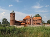
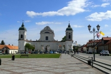
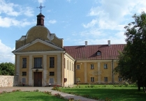
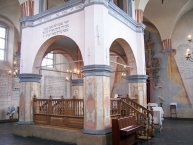
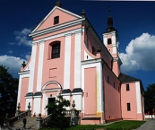
Tykocin is a Baroque town in Podlaskie Voivodeship, Poland.
See
In Tykocin there are over 100 historic buildings. The oldest urban complex of historical Podlasie with preserved layout characteristic for the Jewish town. One of the largest pre-war centers of Jewish culture in Poland.
- ⊙Castle of Augustus II (Tykocin Castle), Puchalskiego 3, ☎ +48 85 718 7372.
- Baroque Market Square with a hospital from 1755
- ⊙Tykocin Synagogue, Kozia 2.
- ⊙Church of the Holy Trinity, 11 Listopada 2, ☎ +48 85 718 1643.
- ⊙ Bernardine monastery
- ⊙Jewish cemetery in Tykocin, Holendry 32.
Eat
- ⊙Pierogarnia Tykocińska, Plac Stefana Czarnieckiego 11, ☎ +48 692 114585.
- ⊙Villa Regent, Sokołowska 3, ☎ +48 85 718 7476.
- ⊙Tejsza Restaurant, Kozia 2, ☎ +48 85 718 7750.
Information about copyright | |
|---|---|
Rights characteristic / license | by-sa: CREATIVE COMMONS Attribution-ShareAlike |
Link to the description of the license | |
Input taken over from: |
Wikivoyage contributors, 'Tykocin', Wikivoyage, The FREE worldwide travel guide that anyone can edit, 13 October 2017, 07:18 UTC, <https://en.wikivoyage.org/w/index.php?title=Tykocin&oldid=3303279> [accessed 20 December 2017] |
taken over / edited on | 20 Dec 2017 - 12 Apr 2018
|
taken over / edited by |
|
340 km
1,2 km
137 m
340 km
1,3 km
154 m
Information about copyright | |
|---|---|
Rights owner | |
Rights characteristic / license | by-sa: CREATIVE COMMONS Attribution-ShareAlike |
Link to the description of the license | |
Image taken over from | pl.wikipedia.org/w/index.php?title=Plik:Wigry_Klasztor_panorama.jpg |
Image has been uploaded | by biroto-Redaktion on 08 Jan 2013
|
Information about copyright | |
|---|---|
Rights owner | |
Rights characteristic / license | by-sa: CREATIVE COMMONS Attribution-ShareAlike |
Link to the description of the license | |
Image taken over from | |
Image has been uploaded | by biroto-Redaktion on 08 Jan 2013
|
Information about copyright | |
|---|---|
Rights owner | |
Rights characteristic / license | by-sa: CREATIVE COMMONS Attribution-ShareAlike |
Link to the description of the license | |
Image taken over from | pl.wikipedia.org/w/index.php?title=Plik:Wigry_Kosciol_front_right.jpg |
Image has been uploaded | by biroto-Redaktion on 08 Jan 2013
|
The former monastery of the Camaldolese Order is located in the village of Wigry. The Camaldolese Hermitage in Wigry belonged to the richest in Europe. It was founded in 1667 by John II Casimir Vasa with the obligation of daily prayer to dismiss all miseries from the country. In 1805, the monastery was dissolved and the monks moved to Bielany near Warsaw. In the monastery in the years 1975-2010 housed the House of Creative Work of the Ministry of Culture and Art. At present, the building has returned to the rule of the church. In the former Hermitage there are guest rooms and apartments that can be rented for a fee. In the monastery you can visit the Apartments and the Papal Chapel, the Crypt in the Church, the Clock Tower, Exhibitions and the reading room of John Paul II , funded after his accommodation in the monastery in 1999. The Late Baroque church with rich interior decoration is still in use and enjoys popularity among newlyweds. There are also concerts of Gregorian chant.
The church crypt contains over forty walled niches with bodies of deceased hermitites. In two glass recesses, which were probably looted by the Germans during the Second World War in search of valuables, the bones blackened from the passage of time. On the wall is a painting depicting the dance of death , an allegory of death inviting a monk to dance.
Information about copyright | |
|---|---|
Rights characteristic / license | by-sa: CREATIVE COMMONS Attribution-ShareAlike |
Link to the description of the license | |
Input taken over from: |
translated from Edytorzy Wikipedii, "Wigry (powiat suwalski)," Wikipedia, wolna encyklopedia, //pl.wikipedia.org/w/index.php?title=Wigry_(powiat_suwalski)&oldid=54240332 (dostęp luty 7, 2019). |
taken over / edited on | 07 Feb 2019
|
taken over / edited by |
|
375 km
0,5 km
185 m

