
Cycle Route Jurajski Rowerowy Szlak Orlich Gniazd
Actions
![]()
Please wait - map data are loading
Added on 16 Dec 2012,
on 11 Jan 2021
Actions
Cycle route metrics
Total distance in km
188
Information about rights to the gps-track data | |
|---|---|
Rights owner | OpenStreetMap and Contributors + biroto-Redaktion (biroto.eu) |
Rights characteristic / license | Contains information from OpenStreetMap, which is made available here under the Open Database License(ODbL) |
Link to the description of the license | |
GPX file taken from | |
GPX file uploaded | by biroto-Redaktion on 11 Jan 2021
|
Track points in total
2.582
Track points per km (avg)
14
Start/endpoint
Start location
Częstochowa, Silesian Voivodeship, PL (250 m NHN)
End location
Krakow, Lesser Poland Voivodeship, PL (202 m NHN)
Sources of information
Portale:
- Webseite Route der Adlerhorste (pl)
Beds4Cyclists, worth visiting and infrastructure
Name and address
Latitude / Longitude
Phone
Fax
Mobile
Type of accommodation
Rating for cyclists
Route km
Dist. to route
Elevation
187 km
3,1 km
213 m
187 km
2,6 km
236 m
187 km
2,6 km
230 m
187 km
3,0 km
219 m
188 km
2,6 km
The Old City of Kraków ![]() , referred to in Polish as Stare Miasto, forms the historical kernel of this vibrant Polish city and is the first target for most travellers to the city for accommodation, eating out, entertainment, and attractions.
, referred to in Polish as Stare Miasto, forms the historical kernel of this vibrant Polish city and is the first target for most travellers to the city for accommodation, eating out, entertainment, and attractions.
Understand
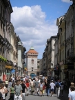
The area of the Old City is bounded by the ring of lightly-forested parkland, known as the Planty, that used to mark the Old City walls and moat. The Wawel, the long-fortified hill at the southern end of the Old City, overlooks the River Vistula, and forms an integral part of this district. The centre of the Old City (and of Kraków itself) is the Rynek Główny (Main Market Square) from which all the main streets radiate.
In this article also the area known in Polish as Śródmieście (Inner city) is covered. It was developed behind torn down medieval city walls on the grounds of surrounding villages and towns and today together with Old City forms the I district of Kraków. Śródmieście is bordered by a ring road al. Trzech Wieszczów from the west and rail tracks from the east.
See
Major attractions
- ⊙Wawel Castle, Wawel 5, ☎ +48 12 422 5155. Wawel is a lime hillock situated on the left bank of the Vistula at an altitude of 228 metres above sea level. This is a symbolic place of great significance for Polish people. The Royal Castle and the Cathedral are situated on the hill. Polish Royalty and many distinguished Poles are interred in the cathedral and royal coronations took place there. It's considered to be the most beautiful castle in Central Europe, besides the Hradcany in Prague.
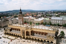
- ⊙Cloth Hall (Sukiennice), Rynek Główny 1-3. Sukiennice was built in the early 14th century in the middle of the Main Market Square as a trading hall in Gothic style. It got its present Renaissance look in 1555. In the 19th century, it was turned into a museum. The first floor was used for great banquets. Now, souvenir shops are there.
- ⊙Town Hall Tower, Rynek Główny 1. Part of the big 13th century Gothic-Renaissance Town Hall that once stood on the Main Market. The town hall was destroyed by the Austrians in the 19th century after they took control of Krakow. It is now one of the branches of Kraków Historical Museum; there's a nice view of the city from upstairs if it is open.
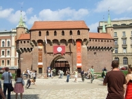
- ⊙Barbican (Barbakan). Barbakan was built in the 15th century as the biggest European defense building of its kind. The Gothic Barbakan was meant to defend the Florian Gate from attacks of the Osman Turks, which were thought to attack Central Europe after conquering Constantinople and the Balkans in the late Middle Age.
- ⊙Florian Gate (Brama Floriańska). This gate is the only part of the medieval walls which has survived. It consists of four towers and the arsenal and gives you a good idea of what the five kilometers of walls around the Old City looked like in the Middle Ages.
Squares
- ⊙Main Market Square (Rynek Główny). A fine medieval square at the heart of the Old City, festooned with churches, restaurants and bars. It is the biggest medieval marketplace worldwide with more than four hectares of area and eleven streets beginning here.
- ⊙Little Market Square (Mały Rynek). A fine medieval square east of the Main Market Square.
- Mary's Square (Plac Mariacki). A small medieval place connecting Main and Little Marketplaces. It was a cemetery in the Middle Ages, but is now a charming and quiet place with the sculpture of a medieval Kracovian student.
- All Saints' Square (Plac Wszystkich Świętych). The name refers to the Gothic All Saints' Church that stood there until the 19th century. Actress Helena Modrzejewska and writer Joseph Conrad lived in houses at this square. There are two beautiful Gothic churches, the St. Francis and the Dominicanus, at its western and eastern ends.
- St. Mary Magdalene Square (Plac św. Marii Magdaleny). A fine square in the center of Okół, the oldest part of the Old Town just under the Wawel. The early baroque St. Peter and Paul Church and the Roman St. Andrew Church are there. In the middle stands the column of Piotr Skarga.
- Stefanus Square (Plac Szczepański). The name refers to the Gothic Stefanus Church that stood there until the 19th century. The secessionist Palace of Art and Old Theatre are there. It was renovated in faux secessionist style, which angered lots of citizens. The fountain plays music in summer evenings.
- Square of the Holy Spirit (Plac św. Ducha). The Gothic Holy Spirit Church is located on the square. Beautiful 19th century Słowacki Theatre is situated there as well.
Churches
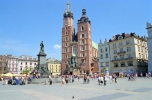
- ⊙St. Mary's Church (Bazylika Mariacka), Plac Mariacki 5 (Located on the southern end of the Rynek), ☎ +48 12 422 5518 21. Not during Mass, 12.00-18.00, 14.00-18.00 on Sundays. The first St. Mary's Church was built in 1220. The façade consists of two unequal towers. The tune (hejnał) is played from one of the towers every hour and on Polish Radio at noon. Inside the church, the east wall is taken up by the altar of Veit Stoss (1477-89). It is the largest piece of medieval art of this kind. There is also an altar with a stone crucifix by Veit Stoss. The wall paintings are by Matejko, Wyspianski, and Mehoffer. 6 zł, reduced 3.
- St. Barbara Church — Founded in the 14th century by Mikolaj Wierzynek as a Gothic grave chapel, it was remodeled in the early Baroque style in 1583. It housed a famous Jesuit college which competed with the Jagiellonian University. Next to the main entrance is the Gethsemane, a complex of stone sculptures by Veit Stoss.
- Church of St. Anne (Kolegiata św. Anny), ul. św. Anny 11, ☎ +48 12 422 5318. This church was built in the 14th century and rebuilt in 1407 in Gothic style. It served as the university church. It was rebuilt in baroque style in 1689 by Tylman from Gameren modeled on S. Andrea della Valle in Rome. The corpus of the church was composed of a wide main nave with three pairs of side chapels. The holy professor of theology Jan Kanty is buried there. His baroque grave is one of the most beautiful in Central Europe.
- St. Adalbert's Church (Kościół św. Wojciecha), Rynek Główny. One of the oldest churches in Central Europe. History of the first wooden church on this site dates from 10th century. It is said to have been built by a pagan cult. Holy Adalbert preached before his missionary expedition to Prussia in the late 10th century. It was rebuilt in the 11th century in Romanesque style and enlarged in the 17th century in baroque shape.
- St. Peter and Paul Church, ul. Grodzka 52a. The oldest baroque building in Poland. It was built in 1597 by Jozef Britius for the Jesuit Order and completed by Jan Trevano. The stone façade is based on the Roman church Il Gesu. You can see the longest Foucault's pendulum in Poland (46,5 m) there. Showings on Thursdays.
- St. Andrew Church, ul. Grodzka 56. This is the best example of the Romanesque style in Poland. It was built in the 11th century by Sieciech, palatine of Duke Wladyslaw Herman. The fortifying character of the church is visible and the church was the only place the Krakovians could flee successfully when the Tatars conquered Kraków in 1241. Two beautiful slim Romanesque towers are covered with baroque helmets and the interior is baroque, too.
- St. Giles Church. This church was founded in the 11th century by Duke Wladyslaw Herman as a votive offering for the birth of their son. It was later rebuilt in the Gothic style at the end of the 13th century. The Holy Mass is offered in English on Sundays at 10:30AM.
- St. Trinity Church. St. Trinity Church, a Dominican church, was built in 1222 in Romanesque style (the refectory still is). It was rebuilt as a three-aisled basilica in the second half of 14th century and the 15th century. It is filled with a countless number of tombs and the set of burial chapels of the 16th and 17th centuries was second only to the Wawel Cathedral necropolis. The great fire of 1850 destroyed much of the church. There is an amazing late 14th-century stone portal richly ornamented with carved floral motifs located here.
- St. Mark Church. This was founded in the second half of the 13th century by Duke Boleslaw Wstydliwy. On the wall of the apse stands the sculpted group Golgotha. Inside the church is a rococo pulpit with a worth seeing cross.
- St. Thomas Church, ul. św. Jana. Built in 1618, this church was constructed in early baroque style for the Carmelichans. Later, it was used by the nuns of the hospital of the Holy Ghost.
- Holy Cross Church. It was constructed in 1186. The oldest part of the church is a stone presbytery, while a brick part of the construction dates from the 15th century. The interior is very beautifully decorated with wall paintings dating back to 1420, like 'The Agony in the Garden' in the chapel and a wonderful Gothic palm vault which is based on only one very high pillar.
- St. Martin Church — This church was raised in 1637 in Baroque style for the Discalced Carmelite nuns, but is now a Protestant church. The Gothic crucifix above the altar is one of the oldest in Poland.
- Pijary Church — Built in 1718 by Kasper Bazanka, the late baroque shape of the façade was made by Franciszek Placidi in 1759. It was based on the Il Gesu church in Rome, but aiming to enhance the frontal effect the architect added a decorative top story and flattened the divisions of the elevation.
- St. John's the Baptist and St. John's the Evangelist Church — It was built by Piotr Wlast from Skrzynno in the 12th century in Romanesque style. In the 17th century, the church was altered in Baroque style. The high altar contains a Renaissance painting called "The Mother of God redeeming the Slaves".
- St. Francis Church (Franciscans) — Founded in the first half of the 13th century in Romanique style. In the 15th century, the church received its final Gothic form. In 1850, the grand fire of Kraków destroyed much of the church. The reconstruction and redecoration took several dozen years. The present secession interior was made by Stanislaw Wyspianski. The most authentic part of the church is the northern elevation of the transept, surviving almost intact in its 13th century form. A place of special beauty are the Gothic cloisters surrounding the rectangular viridarium, dating mostly from the first half of the 15th century.
- Reformatory Church of St. Casimir — Built in 1666, together with the monastery in baroque style. In the crypta are graves of the brothers with mummified bodies, due to the special microclimate.
- St. Joseph Church — This church was built in 1694 at the place of the Tęczyński Palace in baroque style. It was damaged in the big fire of 1850 but the interior was saved.
- Church Of Our Lady Of Snows — Constructed in 1632 founded by Anna Lubomirska as a vote to commemorate the victorious battle in 1621 in Chocim against the Osmans. It was destroyed during the Swedish invasion in 1655 and rebuilt in 1671. The main altar has the painting of the "Our Lady of Snows", the gift of Pope Urban VIII. Next to the church stands a cloister with some fragments of the defensive medieval architecture, like a brick tower from the 13th century.
Monasteries
- ⊙Dominicans. The Dominicans came in 1222 to Kraków. After the Tatars destroyed this monastery, they rebuilt it. Duke Leszek, the Black of Kraków, and Bishop Iwo Odrowaz were buried inside the church in the 13th century. Also the great Italian Humanist Fillipo Callimachus was buried there in the 15th century. His grave was made by Veit Stoss and Peter Vischer. There are 13 chapels inside the church, the Sobieski Chapel with graves of the family of king Jan III Sobieski, the golden Myszkowski Chapel full of pretty baroque and gold, the manierist Dominican Chapel by Santi Gucci are the most beautiful. The Renaissance cross ways are full of epitaphs and baroque paintings by Tomasz Dolabella. A beautiful Romanique Crypta is under the cross ways.
- ⊙Franciscans. The Franciscans came in 1237 to Kraków. Their first monastery was destroyed by the Tatars in 1241 and 1259. In 1269, the saint Salomea was buried inside the St. Francis Church. In 1462, 1655 and 1850 parts of the monastery burned. The inside is Gothic and secession. The famous window "Good Father the Creator" by Stanislaw Wyspianski is there. The cross ways are very worth seeing with their Gothic frescoes. It has been a basilica since 1920.
Palaces
- Palace of the Bishops of Krakow (Pałac Biskupow Krakowskich), ul. Franciszkańska 3. Renaissance palace with a beautiful yard. It is world famous as the home of Pope John Paul II. Starting in 1963, he lived there as the bishop/cardinal of Kraków. After he became pope, he always stayed at there while in Kraków. His small talks from the window with Krakowians are famous. Often one can find a candle in the window and many candles and flowers under it.
- Bishop Erazm Ciołek Palace (Pałac Biskupa Erazma Ciolka), ul. Kanonicza 17.
- Palace of Art (Pałac Sztuki), pl. Szczepański 4. Mon-Fri 08:15-18.00, Sat-Sun 10:00-18:00. 10 zł adults, 5 zł reduced.
- Pałac Wielkopolskich (Palace of the Wielkopolskis), pl. Wszystkich Świętych (Town Hall today).
- Pałac Zabarskich (Palace of the Zabarskis), Rynek Główny 20 (Goethe Institut).
- Pałac Pod Baranami (Palace Under the Lambs), Rynek Główny 27.
- Pałac Pod Krzysztofory (Palace under the Krzysztofory), Rynek Główny 35 (Kraków Historical Museum).
Museums
- ⊙Rynek Underground (Podziemia Rynku), Rynek Główny 1 (entrance in Sukiennice opposite the fountain). 10.00–20.00/22.00; closed every first Tuesday of a month. Shows relics of structures hidden under the current Market Square surface. 17 zł, reduced /group 14.
Eat
Budget
- ⊙Gospoda Koko, ul. Gołębia 8, ☎ +48 12 430 2135. 8AM-3AM, yes 3AM!!!. Quite small, quirky self-service restaurant. The menu is in Polish and English. The fare is typically Polish, the daily deal is a soup followed by a main served with a side salad at a fixed price of 14 zł. Half of this for less hungry costs 9.5 zł. 14zł.
Mid-range
- ⊙Cechowa, ul. Jagiellońska 11. Traditional Polish cuisine, not expensive. A TAM exhibition in the pub in the cellar.
- ⊙Chimera, ul. św. Anny 3. Restaurant with traditional Polish cuisine located in a cellar and an inexpensive salad bar (with big variety of salads) located in the yard of a Renaissance house. Beer garden and wine cellar.
- ⊙Jarema, plac Jana Matejki 5. ☎ +48 12 429 3669. Typical Polish and Kresy cuisine, excellent. The service is excellent as well.
Information about copyright | |
|---|---|
Rights characteristic / license | by-sa: CREATIVE COMMONS Attribution-ShareAlike |
Link to the description of the license | |
Input taken over from: |
Wikivoyage contributors, 'Kraków/Old Town', Wikivoyage, The FREE worldwide travel guide that anyone can edit, 15 May 2016, 14:12 UTC, <https://en.wikivoyage.org/w/index.php?title=Krak%C3%B3w/Old_Town&oldid=2996960> [accessed 30 August 2016] |
taken over / edited on | 30 Nov 2015 - 20 Sep 2016
|
taken over / edited by |
|
![]()