
Cycle Route Om Sydostleden
No. of cycle route 2
Actions
![]()
Please wait - map data are loading
Added on 09 Feb 2015,
last edited by biroto-Redaktion on 12 Mar 2024
Actions
Cycle route metrics
Total distance in km
276
Information about rights to the gps-track data | |
|---|---|
Rights owner | OpenStreetMap and Contributors + biroto-Redaktion (biroto.eu) |
Rights characteristic / license | Contains information from OpenStreetMap, which is made available here under the Open Database License(ODbL) |
Link to the description of the license | |
GPX file taken from | |
GPX file uploaded | by biroto-Redaktion on 12 Mar 2024
|
Track points in total
3.649
Track points per km (avg)
13
Start/endpoint
Start location
Växjö, SE (168 m NHN)
End location
Simrishamn, SE (13 m NHN)
Signposting
|

Sources of information
WebSites:
Beds4Cyclists, worth visiting and infrastructure
Name and address
Latitude / Longitude
Phone
Fax
Mobile
Type of accommodation
Rating for cyclists
Route km
Dist. to route
Elevation
108 km
0,0 km
4 m
174 km
0,1 km
19 m
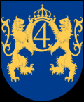
Information about copyright | |
|---|---|
Rights owner | Marmelad |
Rights characteristic / license | by-sa: CREATIVE COMMONS Attribution-ShareAlike |
Link to the description of the license | |
Image taken over from | da.wikipedia.org/wiki/Kristianstad#/media/File:Kristianstad_vapen.svg |
Image has been uploaded | by Ottocolor on 22 Feb 2017
|
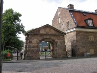
Information about copyright | |
|---|---|
Rights owner | Måns Sjödahl |
Rights characteristic / license | by-sa: CREATIVE COMMONS Attribution-ShareAlike |
Link to the description of the license | |
Image taken over from | https://da.wikipedia.org/wiki/Kristianstad#/media/File:Kristianstad_070628-5.JPG |
Image has been uploaded | by Ottocolor on 22 Feb 2017
|
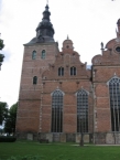
Information about copyright | |
|---|---|
Rights owner | Måns Sjödahl |
Rights characteristic / license | by-sa: CREATIVE COMMONS Attribution-ShareAlike |
Link to the description of the license | |
Image taken over from | https://da.wikipedia.org/wiki/Kristianstad#/media/File:Kristianstad_070628-2.JPG |
Image has been uploaded | by Ottocolor on 22 Feb 2017
|
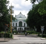
Information about copyright | |
|---|---|
Rights owner | Måns Sjödahl |
Rights characteristic / license | by-sa: CREATIVE COMMONS Attribution-ShareAlike |
Link to the description of the license | |
Image taken over from | https://da.wikipedia.org/wiki/Kristianstad#/media/File:Kristianstad_070628-7.JPG |
Image has been uploaded | by Ottocolor on 22 Feb 2017
|
Kristianstad (Swedish pronunciation: [krɪˈɧanːsta], older spelling Christianstad) is a city ![]() and the seat of Kristianstad Municipality, Skåne County, Sweden with 35,711 inhabitants in 2010. During the last 15 years, it has gone from a garrison town to a developed commercial city, today attracting visitors in the summertime mainly from Germany, Denmark and The Netherlands.
and the seat of Kristianstad Municipality, Skåne County, Sweden with 35,711 inhabitants in 2010. During the last 15 years, it has gone from a garrison town to a developed commercial city, today attracting visitors in the summertime mainly from Germany, Denmark and The Netherlands.
The city was founded in 1614 by King Christian IV of Denmark ![]() , the city's name literally means 'Town of Christian', as a planned city
, the city's name literally means 'Town of Christian', as a planned city ![]() after the burning of the nearby town of Vä
after the burning of the nearby town of Vä ![]() and moving the city rights
and moving the city rights ![]() of the neighbouring town of Sölvesborg
of the neighbouring town of Sölvesborg ![]() and Åhus to the new town. The purpose of the town was to safeguard the eastern half of the Danish province of Scania against any future raids from Sweden in the north, but also as a symbol of the power of Christian himself. One of these raids had sacked the nearby town of Vä in 1612. Vä then lost its charter and the people were moved to the new, better fortified city. The king also founded the town of Christianopel
and Åhus to the new town. The purpose of the town was to safeguard the eastern half of the Danish province of Scania against any future raids from Sweden in the north, but also as a symbol of the power of Christian himself. One of these raids had sacked the nearby town of Vä in 1612. Vä then lost its charter and the people were moved to the new, better fortified city. The king also founded the town of Christianopel ![]() in eastern Blekinge
in eastern Blekinge ![]() to serve a similar purpose.
to serve a similar purpose.
Sweden's lowest point, at 2.41 meters below mean sea level ![]() , is located in Kristianstad. Because of this, parts of the city have to be protected from flooding by a system of levees
, is located in Kristianstad. Because of this, parts of the city have to be protected from flooding by a system of levees ![]() and water pumps. To expand the city, large areas of low-lying wetlands have had to be walled in, especially to the east. To prevent future flooding of the city center, the existing levees are in the process of being reinforced and new levees against both Helge å
and water pumps. To expand the city, large areas of low-lying wetlands have had to be walled in, especially to the east. To prevent future flooding of the city center, the existing levees are in the process of being reinforced and new levees against both Helge å ![]() and Hammarsjön are under construction. An extensive system of ponds and dams is also under construction. The threat of flooding became substantial during late winter 2002, when the greater part of the public park Tivoliparken was under water. However, the wetlands around the city are starting to be regarded more as an asset, not least thanks to the creation of Kristianstads Vattenrike Biosphere Reserve
and Hammarsjön are under construction. An extensive system of ponds and dams is also under construction. The threat of flooding became substantial during late winter 2002, when the greater part of the public park Tivoliparken was under water. However, the wetlands around the city are starting to be regarded more as an asset, not least thanks to the creation of Kristianstads Vattenrike Biosphere Reserve ![]() . Today the Vattenriket is a Unesco biosphere reserve.
. Today the Vattenriket is a Unesco biosphere reserve.
Information about copyright | |
|---|---|
Rights characteristic / license | by-sa: CREATIVE COMMONS Attribution-ShareAlike |
Link to the description of the license | |
Input taken over from: |
Kristianstad. (2016, November 25). In Wikipedia, The Free Encyclopedia. Retrieved 15:17, February 22, 2017, from https://en.wikipedia.org/w/index.php?title=Kristianstad&oldid=751359636 |
taken over / edited on | 22 Feb 2017
|
taken over / edited by |
|
174 km
0,1 km
10 m
Hours of opening
Mo-Fr 10:00-17:00, Sa 10:00-14:00
175 km
1,9 km
9 m