
Cycle Route Aare-Route - Oberwald (Gletsch)–Koblenz
No. of cycle route 8
Actions
![]()
Please wait - map data are loading
Added on 13 Dec 2011,
last edited by biroto-Redaktion on 01 Jan 2021
Actions
Cycle route metrics
Total distance in km
316
Information about rights to the gps-track data | |
|---|---|
Rights owner | OpenStreetMap and Contributors + biroto-Redaktion (biroto.eu) |
Rights characteristic / license | Contains information from OpenStreetMap, which is made available here under the Open Database License(ODbL) |
Link to the description of the license | |
GPX file taken from | |
GPX file uploaded | by biroto-Redaktion on 01 Jan 2021
|
Track points in total
5.723
Track points per km (avg)
18
Start/endpoint
Start location
Obergoms, Wallis, CH (1762 m NHN)
End location
Koblenz, Aargau, CH (318 m NHN)
Signposting
|
|

Sources of information
Beds4Cyclists, worth visiting and infrastructure
Name and address
Latitude / Longitude
Phone
Fax
Mobile
Type of accommodation
Rating for cyclists
Route km
Dist. to route
Elevation
1 km
2,9 km
1.374 m
4 km
2,4 km
2.263 m
Information about copyright | |
|---|---|
Rights owner | |
Rights characteristic / license | by-sa: CREATIVE COMMONS Attribution-ShareAlike |
Link to the description of the license | |
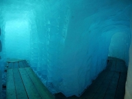
Image taken over from | https://commons.wikimedia.org/wiki/File:Rhone_glacier_innen1.jpg |
Image has been uploaded | by biroto-Redaktion on 31 Jul 2016
|
Information about copyright | |
|---|---|
Rights owner | |
Rights characteristic / license | by-sa: CREATIVE COMMONS Attribution-ShareAlike |
Link to the description of the license | |
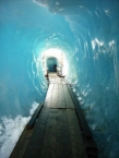
Image taken over from | https://commons.wikimedia.org/wiki/File:Wallis_Furkapass_Rhônegletscher_Eisgrotte_08.JPG |
Image has been uploaded | by biroto-Redaktion on 31 Jul 2016
|
Information about copyright | |
|---|---|
Rights owner | |
Rights characteristic / license | by: CREATIVE COMMONS Attribution |
Link to the description of the license | |
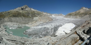
Image taken over from | https://commons.wikimedia.org/wiki/File:Rhonegletscher_-_Sept_2012.JPG |
Image has been uploaded | by biroto-Redaktion on 31 Jul 2016
|
Weil der Rhonegletscher an der Furkapassstraße ![]() liegt, einer klassischen Reiseroute durch die Schweizer Alpen, ist er der am leichtesten zugängliche Gletscher der Schweiz. Vom Hotel Belvédère an der Passstraße ist die Gletscherzunge durch einen wenige 100 m langen kostenpflichtigen Fussweg erschlossen. Hier kann man eine Eisgrotte besuchen. Im Tal von Gletsch kennzeichnen etwa 1,5 m hohe pyramidenförmige Säulen mit Jahreszahlen (ab 1815) den Gletscherschwund im 19. Jahrhundert.
liegt, einer klassischen Reiseroute durch die Schweizer Alpen, ist er der am leichtesten zugängliche Gletscher der Schweiz. Vom Hotel Belvédère an der Passstraße ist die Gletscherzunge durch einen wenige 100 m langen kostenpflichtigen Fussweg erschlossen. Hier kann man eine Eisgrotte besuchen. Im Tal von Gletsch kennzeichnen etwa 1,5 m hohe pyramidenförmige Säulen mit Jahreszahlen (ab 1815) den Gletscherschwund im 19. Jahrhundert.
Information about copyright | |
|---|---|
Rights characteristic / license | by-sa: CREATIVE COMMONS Attribution-ShareAlike |
Link to the description of the license | |
Input taken over from: |
Seite „Rhonegletscher“. In: Wikipedia, Die freie Enzyklopädie. Bearbeitungsstand: 14. Juni 2016, 12:38 UTC. URL: https://de.wikipedia.org/w/index.php?title=Rhonegletscher&oldid=155286651 (Abgerufen: 31. Juli 2016, 14:46 UTC) |
taken over / edited on | 31 Jul 2016
|
taken over / edited by |
|
Hours of opening
Anfang Juni - bis 2. Hälfte Oktober, täglich von 8.00 - 18.00 Uhr, im Hochsommer bis ca. 19.30 Uhr. (Kurzfristige Sperrung nach Wettereinbrüchen vorbehalten)
32 km
0,0 km
627 m
38 km
2,1 km
1.174 m
Hours of opening
07.04. - 27.06.2014 / 20.10. - 19.12.2014 | |
Montag - Freitag | 08.30-12.00 |
Samstag - Sonntag | geschlossen |
28.06. - 19.10.2014 / 20.12.2014 - 06.04.2015 | |
Montag - Sonntag | 08.00-17.00 |
Öffnungszeiten Feiertage: | |
Freitag, 1. August 2014, | |
38 km
0,2 km
603 m
![]()