
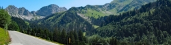
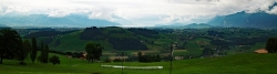
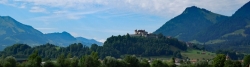
Alps Panorama Cycle Route - St. Margrethen–Aigle
No. of cycle route 4
Actions
![]()
Please wait - map data are loading
Added on 12 Dec 2011,
last edited by biroto-Redaktion on 03 Sep 2022
Actions
Cycle route metrics
Total distance in km
497
Information about rights to the gps-track data | |
|---|---|
Rights owner | OpenStreetMap and Contributors + biroto-Redaktion (biroto.eu) |
Rights characteristic / license | Contains information from OpenStreetMap, which is made available here under the Open Database License(ODbL) |
Link to the description of the license | |
GPX file taken from | |
GPX file uploaded | by biroto-Redaktion on 03 Sep 2022
|
Track points in total
11.150
Track points per km (avg)
22
Start/endpoint
Start location
St. Margrethen, Sankt Gallen, CH (402 m NHN)
End location
Aigle, Waadt, CH (405 m NHN)
Signposting
|
|

Sources of information
Portale:
- Alpenpanorama-Route auf Veloland Schweiz
Bücher/Karten:
- Veloland Schweiz: 4: Alpenpanorama-Route: Die offiziellen Routenführer
Travel reports about cycle tours
Information about copyright | |
|---|---|
Rights owner | |
Rights characteristic / license | © all rights reserved. |
Image has been uploaded | by Tandemteam-Traudel_und_Dieter on 06 Apr 2017
|
28 Jul 2012
53 km
A stage of the tour »Vom Bodensee über Genfersee nach Basel« of user Tandemteam-Traudel_und_Dieter
Information about copyright | |
|---|---|
Rights owner | |
Rights characteristic / license | © all rights reserved. |
Image has been uploaded | by Tandemteam-Traudel_und_Dieter on 06 Apr 2017
|
29 Jul 2012
83 km
A stage of the tour »Vom Bodensee über Genfersee nach Basel« of user Tandemteam-Traudel_und_Dieter
Information about copyright | |
|---|---|
Rights owner | |
Rights characteristic / license | © all rights reserved. |
Image has been uploaded | by Tandemteam-Traudel_und_Dieter on 06 Apr 2017
|
30 Jul 2012
65 km
A stage of the tour »Vom Bodensee über Genfersee nach Basel« of user Tandemteam-Traudel_und_Dieter
Information about copyright | |
|---|---|
Rights owner | |
Rights characteristic / license | © all rights reserved. |
Image has been uploaded | by Tandemteam-Traudel_und_Dieter on 06 Apr 2017
|
31 Jul 2012
50 km
A stage of the tour »Vom Bodensee über Genfersee nach Basel« of user Tandemteam-Traudel_und_Dieter
Information about copyright | |
|---|---|
Rights owner | |
Rights characteristic / license | © all rights reserved. |
Image has been uploaded | by Tandemteam-Traudel_und_Dieter on 06 Apr 2017
|
01 Aug 2012
41 km
A stage of the tour »Vom Bodensee über Genfersee nach Basel« of user Tandemteam-Traudel_und_Dieter
Information about copyright | |
|---|---|
Rights owner | |
Rights characteristic / license | © all rights reserved. |
Image has been uploaded | by Tandemteam-Traudel_und_Dieter on 06 Apr 2017
|
02 Aug 2012
43 km
A stage of the tour »Vom Bodensee über Genfersee nach Basel« of user Tandemteam-Traudel_und_Dieter
Information about copyright | |
|---|---|
Rights owner | |
Rights characteristic / license | © all rights reserved. |
Image has been uploaded | by Tandemteam-Traudel_und_Dieter on 07 Apr 2017
|
03 Aug 2012
78 km
A stage of the tour »Vom Bodensee über Genfersee nach Basel« of user Tandemteam-Traudel_und_Dieter
Information about copyright | |
|---|---|
Rights owner | |
Rights characteristic / license | © all rights reserved. |
Image has been uploaded | by Tandemteam-Traudel_und_Dieter on 12 Apr 2017
|
04 Aug 2012
82 km
A stage of the tour »Vom Bodensee über Genfersee nach Basel« of user Tandemteam-Traudel_und_Dieter
Beds4Cyclists, worth visiting and infrastructure
Name and address
Latitude / Longitude
Phone
Fax
Mobile
Type of accommodation
Rating for cyclists
Route km
Dist. to route
Elevation
1 km
2,2 km
393 m
1 km
3,8 km
396 m
9 km
3,7 km
399 m
Information about copyright | |
|---|---|
Rights owner | |
Rights characteristic / license | by-sa: CREATIVE COMMONS Attribution-ShareAlike |
Link to the description of the license | |
Image taken over from | |
Image has been uploaded | by biroto-Redaktion on 27 Apr 2013
|
Information about copyright | |
|---|---|
Rights owner | |
Rights characteristic / license | by-sa: CREATIVE COMMONS Attribution-ShareAlike |
Link to the description of the license | |
Image taken over from | |
Image has been uploaded | by biroto-Redaktion on 27 Apr 2013
|
Information about copyright | |
|---|---|
Rights owner | |
Rights characteristic / license | by-sa: CREATIVE COMMONS Attribution-ShareAlike |
Link to the description of the license | |
Image taken over from | |
Image has been uploaded | by biroto-Redaktion on 27 Apr 2013
|
Information about copyright | |
|---|---|
Rights owner | |
Rights characteristic / license | by-sa: CREATIVE COMMONS Attribution-ShareAlike |
Link to the description of the license | |
Image taken over from | |
Image has been uploaded | by biroto-Redaktion on 27 Apr 2013
|
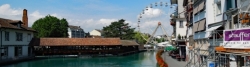
Rheineck ist eine Gemeinde im Kanton St. Gallen.
Sehenswürdigkeiten
- Altstadt mit Fachwerkhäusern, frühneuzeitlichen Bauten und Jugendstilhäusern
- Alte Landschreiberei viergeschossiger Massiv- und Fachwerkbau, datiert aus 1639, möglicherweise älter, da auf dem Gelände des alten Schlosses Rinegge errichtet (ebenso das Schlössli, siehe unten)
- Altes Amtshaus ehemaliger Sitz der Landvögte, stilistisch interessante Symbiose zwischen Gotik und Frühbarock, erbaut um 1580
- Altes Primalschulhaus spätklassizistisches Anwesen in Privatbesitz, erbaut 1881
- Burgplateau über der Altstadt gelegene Ebene mit Aussicht auf Bodensee, die Allgäuer Alpen und den Bregenzerwald
- Burgstock Burgruine (Wachturm) aus dem 12. Jahrhundert
- Custerhof Barockbau mit Mansartdach und aufwändigen Rokoko-Strukturen im Inneren, erbaut 1750 bis 1753
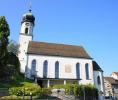
- Evangelische Pfarrkirche St. Jakob
 gegründet im Mittelalter, erhaltener Chor aus dem Neubau 1519, 1722 barockisiert, 1980/81 restauriert
 - Hinter dem Markt früher auch 'Judengasse' genannt, ältestes, erhaltenes Quartier, da vom Brand 1876 weitgehend unversehrt
- Katholische St. Theresienkirche erbaut 1932/1933, eine der ersten modernen Kirchenbauten der Schweiz
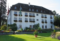
- Löwenhof Palais mit vorgelagerter französischer Gartenanlage mit Orangerie, Springbrunnen und Pavillon, erbaut 1742-1746
- Oberstufenschulhaus klassizistisches Gebäude im neubarocken Stil, erbaut 1905/1906
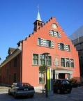
- Rathaus errichtet 1553 bis 1555, renoviert und umgebaut 1876 und 1929/30, mit Treppengiebel und hölzerenem Vierecktürmchen
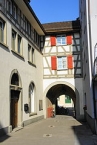
- Rhytor (Rheintor) letztes erhaltenes Stadttor aus dem 15. Jahrhundert mit in Fachwerkkonstruktion ausgeführtem Aufbau und Gemälde
- Schlössli am Ort des alten um 1445 zerstörten Schlosses Rinegge errichtete, aus 5 Teilen bestehende Gebäudegruppe aus dem 17. Jahrhundert
- Weiergasse Straßenzug entlang der ehemaligen Stadtmauer mit teilweise erhaltenen Resten der Befestigung
Information about copyright | |
|---|---|
Rights characteristic / license | by-sa: CREATIVE COMMONS Attribution-ShareAlike |
Link to the description of the license | |
Input taken over from: |
Seite „Rheineck SG“. In: Wikipedia, Die freie Enzyklopädie. Bearbeitungsstand: 3. April 2013, 19:40 UTC. URL: http://de.wikipedia.org/w/index.php?title=Rheineck_SG&oldid=116866930 (Abgerufen: 27. April 2013, 14:19 UTC) |
taken over / edited on | 27 Apr 2013
|
taken over / edited by |
|
9 km
3,7 km
394 m
14 km
5,0 km
464 m
![]()