
Cycle Route Border Loop
Actions
![]()
Please wait - map data are loading
Added on 29 Nov 2011,
last edited by biroto-Redaktion on 29 Oct 2023
Actions
Cycle route metrics
Total distance in km
391
Information about rights to the gps-track data | |
|---|---|
Rights owner | OpenStreetMap and Contributors + biroto-Redaktion (biroto.eu) |
Rights characteristic / license | Contains information from OpenStreetMap, which is made available here under the Open Database License(ODbL) |
Link to the description of the license | |
GPX file taken from | |
GPX file uploaded | by biroto-Redaktion on 29 Oct 2023
|
Track points in total
5.916
Track points per km (avg)
15
Start/endpoint
Start location
Galashiels, SCT, GB (108 m NHN)
End location
Galashiels, SCT, GB (108 m NHN)
Beds4Cyclists, worth visiting and infrastructure
Name and address
Latitude / Longitude
Phone
Fax
Mobile
Type of accommodation
Rating for cyclists
Route km
Dist. to route
Elevation
52 km
0,3 km
149 m
Information about copyright | |
|---|---|
Rights owner | |
Rights characteristic / license | by-sa: CREATIVE COMMONS Attribution-ShareAlike |
Link to the description of the license | |
Image taken over from | https://commons.wikimedia.org/wiki/File:Traquair_House_01.jpg |
Image has been uploaded | by biroto-Redaktion on 12 Dec 2020
|
Information about copyright | |
|---|---|
Rights owner | |
Rights characteristic / license | cc0: Public Domain no Rights reserved |
Link to the description of the license | |
Image taken over from | https://commons.wikimedia.org/wiki/File:Traquair_House,_Peeblesshire.jpg |
Image has been uploaded | by biroto-Redaktion on 12 Dec 2020
|
Information about copyright | |
|---|---|
Rights owner | https://commons.wikimedia.org/w/index.php?title=User:Castlehunter |
Rights characteristic / license | by-sa: CREATIVE COMMONS Attribution-ShareAlike |
Link to the description of the license | |
Image taken over from | https://commons.wikimedia.org/wiki/File:Traquair_House_courtyard_with_warrior.jpg |
Image has been uploaded | by biroto-Redaktion on 12 Dec 2020
|
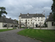
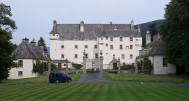
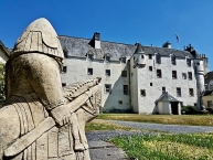
Traquair House, approximately 7 miles southeast of Peebles ![]() , is claimed to be the oldest continually inhabited house in Scotland. Whilst not strictly a castle, it is built in the style of a fortified mansion. It pre-dates the Scottish Baronial style of architecture, and may have been one of the influences on this style. The estate contains the famous Traquair Brewery.
, is claimed to be the oldest continually inhabited house in Scotland. Whilst not strictly a castle, it is built in the style of a fortified mansion. It pre-dates the Scottish Baronial style of architecture, and may have been one of the influences on this style. The estate contains the famous Traquair Brewery.
History
The house is built on the site of a hunting seat used by the Scottish kings from the 12th century, though no part of the present building can be dated with certainty before the 15th century. Alexander I was the first Scottish king to stay and hunt at Traquair. At that time it was a remote "castle", surrounded by forest. Upon Alexander III's death in 1286, the peace of the Borders region was shattered and Traquair became a key link in the chain of defence that guarded the Tweed Valley against English invasion.
Over the next two centuries Traquair's ownership changed often, at times coming under the control of the English, and at others, the Scottish throne. In the 1460s James III conferred the estate on Dr. William Rogers, an eminent musician, and one of his favourites. After holding the lands for upwards of nine years, Dr. Rogers sold them for an insignificant sum in 1478 to the Earl of Buchan. The Earl gifted the estate to his illegitimate son, James Stuart (1480-1513), 1st Laird of Traquair, in 1491. James Stuart obtained letters of legitimation and married the heiress of the Rutherfords, with whom he received the estates of Rutherford and Wells in Roxburghshire. He was killed at the Battle of Flodden. His daughter, Jane Stewart, had a daughter Janet with the Earl of Angus born out of wedlock, who married Patrick Ruthven, 3rd Lord Ruthven.
Traquair remained the family seat of the Earls of Traquair for the next four centuries.
In 1875 Traquair passed to a cousin of the Stuarts, Henry Constable Maxwell. He was a direct descendant, but via the female line.
Features
Traquair is a 50-room house. The rooms include "The Drawing Room", containing ancestral portraits and photographs of the current residents; "The Dressing Room", which is decorated to demonstrate life in former times; "The Museum Room", containing a mural dating from 1530, one of the oldest to survive in a secular building in Scotland, as well as charters stamped with the royal seals and signatures of the Scottish Kings; "The King's Room", where Mary, Queen of Scots stayed in 1566 and which contains some relics belonging to her and the Jacobites, such as her rosary, crucifix, purse, a silk quilt, and letters bearing her signature; "The Still Room", where breakfast is taken among the 18th century porcelain that decorates the shelves; and "The Dining Room", one of the last additions to the house, built in the late 17th century. There is a Roman Catholic chapel built in 1829, following the Catholic emancipation. The 18th century library contains more than 3,000 volumes. Although three lairds made alterations to the house prior to the 17th century, Traquair has changed little, architecturally, since then.
The Bear Gates at the main entrance to the grounds were installed by the fifth Earl, Charles Stuart, in 1738. When they were closed, after Charles Edward Stuart (Bonnie Prince Charlie) passed through in 1745, the Earl vowed they would never be opened again until a Stuart king returned.
Brewery
The Traquair House Brewery was started in 1965 by Peter Maxwell Stuart using the 18th century domestic brewery equipment that had previously been used to make beer for the house. Ale is fermented in the original oak tuns, some of which are over 200 years old. The brewery makes a range of beers, though the two main brands are Jacobite Ale and House Ale.
Ale was brewed at Traquair during the reign of Mary, Queen of Scots. In 1739 a 200-gallon copper was installed in the brew house under the chapel.
Information about copyright | |
|---|---|
Rights characteristic / license | by-sa: CREATIVE COMMONS Attribution-ShareAlike |
Link to the description of the license | |
Input taken over from: |
Wikipedia contributors, 'Traquair House', Wikipedia, The Free Encyclopedia, 5 December 2020, 16:07 UTC, https://en.wikipedia.org/w/index.php?title=Traquair_House&oldid=992497669 [accessed 12 December 2020] |
taken over / edited on | 12 Dec 2020
|
taken over / edited by |
|
239 km
0,0 km
50 m
Information about copyright | |
|---|---|
Rights owner | |
Rights characteristic / license | by-sa: CREATIVE COMMONS Attribution-ShareAlike |
Link to the description of the license | |
Image taken over from | |
Image has been uploaded | by biroto-Redaktion on 12 Dec 2020
|
Information about copyright | |
|---|---|
Rights owner | |
Rights characteristic / license | by-sa: CREATIVE COMMONS Attribution-ShareAlike |
Link to the description of the license | |
Image taken over from | https://commons.wikimedia.org/wiki/File:Scottish_Borders_Kelso_Abbey_1.jpg |
Image has been uploaded | by biroto-Redaktion on 12 Dec 2020
|
Kelso is a small market town in the Borders region of southern Scotland. Its name probably derives from Calk Heugh - the "chalk outcrop" which its two rivers cut through. These are the Teviot and Tweed, joining here, both famed for salmon fishing. The town grew up around its Abbey, whose monks farmed the fertile valleys. Its town centre is of a style common in northern France and the Low Countries but rare in Scotland, with a large market square, and Flemish-style buildings. The main reasons to visit are the Abbey and Floors Castle.
Difficult to believe now, but the tiny village of Roxburgh five miles south was once an important settlement, and indeed briefly the capital of Scotland.
See
- ⊙Kelso Abbey, Roxburgh St, Kelso TD5 7JD. Apr-Sept daily 09:30-17:30, Oct-Mar Sa-W 10:00-16:00. Built 1128-1143 by the Tironensian monastic order (who'd split from the Benedictines), this was once one of the wealthiest and grandest monasteries in Scotland. But it suffered repeated attack and destruction, and was in a poor state even before the 1560 Reformation. All that remains is the west tower and the transept, still a striking piece of Romanesque architecture. Free.
 (updated Jan 2019)
 - Kelso Square The largest market square in Scotland with well preserved 18th and 19th century architecture reminiscent if the low countries.
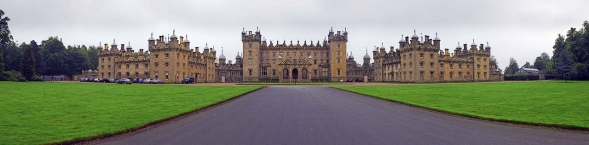
- ⊙Floors Castle (1 mile north of Kelso (the main gates are in the town)). Main residence of the Duke of Roxburghe, largest inhabited house in Scotland and open to visitors in the summer months. Art collection, tea room, garden centre and country sports. (updated Apr 2017)
- ⊙Roxburgh Castle. Ruins of a medieval castle established by David I and birthplace of Alexander III. Roxburgh Castle was strategically important from the 12th to the 15th centuries and the adjoining town of Roxburgh (of which there is now no visible trace) was an important royal burgh and centre of agricultural trade with Europe. The castle is in ruins and very little of the stonework is now visible. There is however an impressive earthwork mound topped by remnants of thick stone fortifications. Remnants of the main gate are visible to the west of the castle. Worth visiting in spring via a pleasant riverside walk by the river Teviot when the weather relatively clement and before an overgrowth of Nettles impedes access. (updated Apr 2017)
Information about copyright | |
|---|---|
Rights characteristic / license | by-sa: CREATIVE COMMONS Attribution-ShareAlike |
Link to the description of the license | |
Input taken over from: |
Wikivoyage contributors, 'Kelso (Scotland)', Wikivoyage, The FREE worldwide travel guide that anyone can edit, 20 June 2020, 13:53 UTC, https://en.wikivoyage.org/w/index.php?title=Kelso_(Scotland)&oldid=4004858 [accessed 12 December 2020] |
taken over / edited on | 12 Dec 2020
|
taken over / edited by |
|
381 km
0,4 km
72 m
Information about copyright | |
|---|---|
Rights owner | |
Rights characteristic / license | by-sa: CREATIVE COMMONS Attribution-ShareAlike |
Link to the description of the license | |
Image taken over from | https://commons.wikimedia.org/wiki/File:Schottland_Dryburgh_Abbey.jpg |
Image has been uploaded | by biroto-Redaktion on 12 Dec 2020
|
Information about copyright | |
|---|---|
Rights owner | |
Rights characteristic / license | by-sa: CREATIVE COMMONS Attribution-ShareAlike |
Link to the description of the license | |
Image taken over from | |
Image has been uploaded | by biroto-Redaktion on 12 Dec 2020
|
Information about copyright | |
|---|---|
Rights owner | |
Rights characteristic / license | by-sa: CREATIVE COMMONS Attribution-ShareAlike |
Link to the description of the license | |
Image taken over from | https://commons.wikimedia.org/wiki/File:Dryburgh_Abbey_-_Chapter_House_entrance.jpg |
Image has been uploaded | by biroto-Redaktion on 12 Dec 2020
|
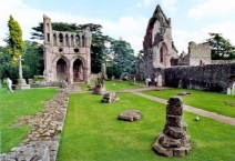
Dryburgh Abbey, near Dryburgh ![]() on the banks of the River Tweed in the Scottish Borders, was nominally founded on 10 November (Martinmas) 1150 in an agreement between Hugh de Morville, Constable of Scotland, and the Premonstratensian canons regular from Alnwick Abbey in Northumberland. The arrival of the canons along with their first abbot, Roger, took place on 13 December 1152.
on the banks of the River Tweed in the Scottish Borders, was nominally founded on 10 November (Martinmas) 1150 in an agreement between Hugh de Morville, Constable of Scotland, and the Premonstratensian canons regular from Alnwick Abbey in Northumberland. The arrival of the canons along with their first abbot, Roger, took place on 13 December 1152.
It was burned by English troops in 1322, after which it was restored only to be again burned by Richard II in 1385, but it flourished in the fifteenth century. It was finally destroyed in 1544, briefly to survive until the Scottish Reformation, when it was given to the Earl of Mar by James VI of Scotland. It is now a designated scheduled monument and the surrounding landscape is included in the Inventory of Gardens and Designed Landscapes in Scotland.
David Steuart Erskine, 11th Earl of Buchan Earl of Buchan bought the land in 1786. Sir Walter Scott and Douglas Haig are buried in its grounds. Their respective tomb and headstone, along with other memorials, are collectively designated a Category A listed building.
Information about copyright | |
|---|---|
Rights characteristic / license | by-sa: CREATIVE COMMONS Attribution-ShareAlike |
Link to the description of the license | |
Input taken over from: |
Wikipedia contributors, 'Dryburgh Abbey', Wikipedia, The Free Encyclopedia, 16 August 2020, 18:55 UTC, <https://en.wikipedia.org/w/index.php?title=Dryburgh_Abbey&oldid=973349637> [accessed 12 December 2020] |
taken over / edited on | 12 Dec 2020
|
taken over / edited by |
|
388 km
0,2 km
83 m
Information about copyright | |
|---|---|
Rights owner | https://commons.wikimedia.org/w/index.php?title=User:Nick.blackbourn |
Rights characteristic / license | by-sa: CREATIVE COMMONS Attribution-ShareAlike |
Link to the description of the license | |
Image taken over from | https://commons.wikimedia.org/wiki/File:Melrose_Abbey_in_the_sun.JPG |
Image has been uploaded | by biroto-Redaktion on 12 Dec 2020
|
Information about copyright | |
|---|---|
Rights owner | |
Rights characteristic / license | by-sa: CREATIVE COMMONS Attribution-ShareAlike |
Link to the description of the license | |
Image taken over from | https://commons.wikimedia.org/wiki/File:Melrose_Abbey_(48891117447).jpg |
Image has been uploaded | by biroto-Redaktion on 12 Dec 2020
|
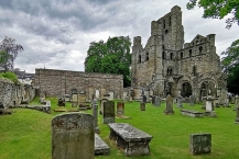
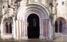
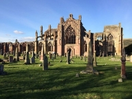
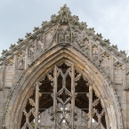
St Mary's Abbey, Melrose is a partly ruined monastery of the Cistercian order in Melrose ![]() , Roxburghshire, in the Scottish Borders. It was founded in 1136 by Cistercian monks at the request of King David I of Scotland and was the chief house of that order in the country until the Reformation. It was headed by the abbot or commendator of Melrose. Today the abbey is maintained by Historic Environment Scotland as a scheduled monument.
, Roxburghshire, in the Scottish Borders. It was founded in 1136 by Cistercian monks at the request of King David I of Scotland and was the chief house of that order in the country until the Reformation. It was headed by the abbot or commendator of Melrose. Today the abbey is maintained by Historic Environment Scotland as a scheduled monument.
The east end of the abbey was completed in 1146. Other buildings in the complex were added over the next 50 years. The abbey was built in the Gothic manner and in the form of a St. John's Cross. A considerable portion of the abbey is now in ruins. A structure dating from 1590 is maintained as a museum open to the public.
Alexander II and other Scottish kings and nobles are buried at the abbey. A lead container believed to hold the embalmed heart of Robert the Bruce was found in 1921 below the Chapter House site; it was found again in a 1998 excavation. This was documented in records of his death. The rest of his body is buried in Dunfermline Abbey ![]() .
.
The abbey is known for its many carved decorative details, including likenesses of saints, dragons, gargoyles and plants. On one of the abbey's stairways is an inscription by John Morow, a master mason, which says, Be halde to ye hende ("Keep in mind, the end, your salvation"). This has become the motto of the town of Melrose.
Information about copyright | |
|---|---|
Rights characteristic / license | by-sa: CREATIVE COMMONS Attribution-ShareAlike |
Link to the description of the license | |
Input taken over from: |
Wikipedia contributors, 'Melrose Abbey', Wikipedia, The Free Encyclopedia, 8 December 2020, 19:05 UTC, <https://en.wikipedia.org/w/index.php?title=Melrose_Abbey&oldid=993091628> [accessed 12 December 2020] |
taken over / edited on | 12 Dec 2020
|
taken over / edited by |
|