
EuroVelo: North Sea Cycle Route - part Shetland to Harwich
No. of cycle route EV12
Actions
![]()
Please wait - map data are loading
Added on 05 Oct 2011,
last edited by biroto-Redaktion on 19 Jan 2024
Actions
Cycle route metrics
Total distance in km
2.713
Information about rights to the gps-track data | |
|---|---|
Rights owner | OpenStreetMap and Contributors + biroto-Redaktion (biroto.eu) |
Rights characteristic / license | Contains information from OpenStreetMap, which is made available here under the Open Database License(ODbL) |
Link to the description of the license | |
GPX file taken from | |
GPX file uploaded | by biroto-Redaktion on 19 Jan 2024
|
Track points in total
42.870
Track points per km (avg)
15
Start/endpoint
Start location
Scatness, Scotland, GB (8 m NHN)
End location
Dover, England, GB (11 m NHN)
Sources of information
Remarks
The second part of the North Sea Cycle Route is available at
For the following countries there are dedicates routes available for the respective parts of the North Sea Cycle Route:
Beds4Cyclists, worth visiting and infrastructure
Name and address
Latitude / Longitude
Phone
Fax
Mobile
Type of accommodation
Rating for cyclists
Route km
Dist. to route
Elevation
479 km
0,0 km
1 m
630 km
0,1 km
14 m
Information about copyright | |
|---|---|
Rights owner | |
Rights characteristic / license | by-sa: CREATIVE COMMONS Attribution-ShareAlike |
Link to the description of the license | |
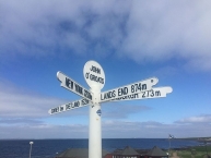
Image taken over from | https://commons.wikimedia.org/wiki/File:John_o'_Groats_Signpost.jpg |
Image has been uploaded | by biroto-Redaktion on 08 May 2017
|
Information about copyright | |
|---|---|
Rights owner | |
Rights characteristic / license | by-sa: CREATIVE COMMONS Attribution-ShareAlike |
Link to the description of the license | |
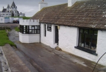
Image taken over from | https://commons.wikimedia.org/wiki/File:Last_House_Museum_-_geograph.org.uk_-_355827.jpg |
Image has been uploaded | by biroto-Redaktion on 08 May 2017
|
John o'Groats (Gaelic: Taigh Iain Ghròt) is a small village in the traditional Scottish county of Caithness and the Highlands region of Scotland.
Understand
John o'Groats is popularly thought of as the northernmost point on the mainland (the counterpart to Land's End ![]() in Cornwall) - although not actually the northernmost point (this honour belongs to Dunnet Head nearby), John o'Groats is certainly the northernmost settlement on Great Britain.
in Cornwall) - although not actually the northernmost point (this honour belongs to Dunnet Head nearby), John o'Groats is certainly the northernmost settlement on Great Britain.
John o'Groats takes its name from one Jan de Groot, a Dutchman who obtained a grant for the ferry from the Scottish mainland to the Orkney Islands ![]() , recently acquired from Norway, from the Scottish King James IV in 1496.
, recently acquired from Norway, from the Scottish King James IV in 1496.
Information about copyright | |
|---|---|
Rights characteristic / license | by-sa: CREATIVE COMMONS Attribution-ShareAlike |
Link to the description of the license | |
Input taken over from: |
Wikivoyage contributors, 'John o'Groats', Wikivoyage, The FREE worldwide travel guide that anyone can edit, 7 May 2017, 12:59 UTC, <https://en.wikivoyage.org/w/index.php?title=John_o%27Groats&oldid=3197844> [accessed 8 May 2017] |
taken over / edited on | 08 May 2017
|
taken over / edited by |
|
640 km
1,5 km
17 m
Information about copyright | |
|---|---|
Rights owner | |
Rights characteristic / license | by-sa: CREATIVE COMMONS Attribution-ShareAlike |
Link to the description of the license | |
Image taken over from | |
Image has been uploaded | by biroto-Redaktion on 08 May 2017
|
Information about copyright | |
|---|---|
Rights owner | |
Rights characteristic / license | by: CREATIVE COMMONS Attribution |
Link to the description of the license | |
Image taken over from | |
Image has been uploaded | by biroto-Redaktion on 08 May 2017
|
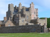
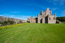
The Castle of Mey (formerly Barrogill Castle) is located in Caithness ![]() , on the north coast of Scotland, about 6 miles (10 km) west of John o' Groats
, on the north coast of Scotland, about 6 miles (10 km) west of John o' Groats ![]() .
.
The lands of Mey belonged to the Bishops of Caithness. The Castle of Mey was built between 1566 and 1572, possibly on the site of an earlier fortification, by George Sinclair, 4th Earl of Caithness. Originally a Z-plan tower house of three storeys, it had a projecting wing at the south-east, and a square tower at the north-west. The Castle passed to George Sinclair's younger son William, founder of the Sinclairs of Mey, although it later became the seat of the Earls. The Castle's name was changed to Barrogill, and the structure was extended several times, in the 17th and 18th centuries, and again in 1821 when Tudor Gothic style alterations were made, to designs by William Burn. Barrogill passed out of the Sinclair family in 1889, on the death of the 15th Earl, and in 1929 it was purchased by Captain FB Imbert-Terry. The Castle was used as an officers' rest home during the Second World War, and in 1950 the estate farms were sold off.
Royal residence
Barrogill Castle was in a semi-derelict state when, in 1952, the estate was purchased by Queen Elizabeth The Queen Mother, the widow of King George VI, who had died earlier in the year. The Queen Mother set about restoring the castle for use as a holiday home, removing some of the 19th-century additions, and reinstating the Castle's original name. She regularly visited it in August and October from 1955 until her death in March 2002; the last visit was in October 2001.
In July 1996, The Queen Mother made the property, the policies, and the farm over to the Queen Elizabeth Castle of Mey Trust, which has opened the castle and garden to the public regularly since her death. It is now open. The Trust opened a new Visitor Centre in early 2007, and the visitor numbers for that year topped 29,000.
Information about copyright | |
|---|---|
Rights characteristic / license | by-sa: CREATIVE COMMONS Attribution-ShareAlike |
Link to the description of the license | |
Input taken over from: |
Wikipedia contributors, 'Castle of Mey', Wikipedia, The Free Encyclopedia, 4 May 2017, 06:40 UTC, <https://en.wikipedia.org/w/index.php?title=Castle_of_Mey&oldid=778618159> [accessed 8 May 2017] |
taken over / edited on | 08 May 2017
|
taken over / edited by |
|
Hours of opening
Opening times for The Castle and Gardens of Mey will be from 17th May to 30th September inclusive, but will be closed from 29th July to 9th August inclusive.
The castle is open every day in season from 10.20 am until last admission at 4.00 pm.
The visitor centre, tearoom, shop, grounds and animal centre are open every day during the normal season from 10.00 am until 5.00 pm.
901 km
0,0 km
23 m
Information about copyright | |
|---|---|
Rights owner | |
Rights characteristic / license | by: CREATIVE COMMONS Attribution |
Link to the description of the license | |
Image taken over from | |
Image has been uploaded | by biroto-Redaktion on 08 May 2017
|
Information about copyright | |
|---|---|
Rights owner | |
Rights characteristic / license | by: CREATIVE COMMONS Attribution |
Link to the description of the license | |
Image taken over from | |
Image has been uploaded | by biroto-Redaktion on 08 May 2017
|
Information about copyright | |
|---|---|
Rights owner | |
Rights characteristic / license | by: CREATIVE COMMONS Attribution |
Link to the description of the license | |
Image taken over from | |
Image has been uploaded | by biroto-Redaktion on 08 May 2017
|
Information about copyright | |
|---|---|
Rights owner | David Greenhalgh |
Rights characteristic / license | cc0: Public Domain no Rights reserved |
Link to the description of the license | |
Image taken over from | |
Image has been uploaded | by biroto-Redaktion on 08 May 2017
|
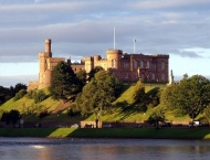
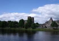
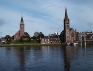
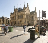
Inverness is a city at the heart of the Scottish Highlands and the principal centre for administration and commerce. It is the most northerly city in the British Isles.
Understand
Advertised as "the Gateway to the Highlands" by the local authority, and long regarded as the capital of the Highlands, Inverness is the centre for commerce and industry in the Scottish Highlands, with continuing new investment in traditional industries and new hi-tech industries. It is also said to be one of the fastest growing cities in Europe.
See
- ⊙Inverness Castle. At the end of the western pedestrian zone. It is a relatively new castle built in 1847 to replace a medieval castle blown up by the Jacobites. It houses the Sheriff Court and cannot be seen as a visitor (you at least should try to never see it from the inside).

- ⊙Inverness Museum & Art Gallery, Castle Wynd (base of Inverness Castle), ☎ +44 1463 237114. The museum has a collection of Pictish stones and wildlife dioramas, as well as historic weapons. Underwent a major refurbishment in 2006, and now contains many artefacts on loan from the National Museum of Scotland in Edinburgh.
- ⊙Old High Church, Church Street. Oldest Church in Inverness, the 'Town Church' of the city. Historic Tour each Friday at 11.30am, June to August. Sunday services at 11.15am, Prayers for Peace and Justice every Friday at 1.05pm, and occasional evening services in the summer, with guest preachers, as advertised.
- ⊙Ship Space, 16 Clachnaharry Road, IV3 8QH, ☎ +44 1463 716839. 10AM - 3PM daily. An interactive and evolving museum in Inverness with nautical artefacts & large ships: e.g. 1:10 scale Titanic, Buckie drifter, RNLI lifeboat & more. Free entry.
- ⊙Inverness Botanic Gardens (formerly: Floral Hall and Gardens), Bught Lane (next to the sports centre), ☎ +44 1463 713553. Glasshouse and gardens, with a range of exotic plants, plus a cafe. Free.
- ⊙Inverness Cathedral (St Andrew’s Cathedral). Scottish Episcopal (Anglican) cathedral, built in 1869. (updated Jul 2015)
Information about copyright | |
|---|---|
Rights characteristic / license | by-sa: CREATIVE COMMONS Attribution-ShareAlike |
Link to the description of the license | |
Input taken over from: |
Wikivoyage contributors, "Inverness," Wikivoyage, The FREE worldwide travel guide that anyone can edit, https://en.wikivoyage.org/w/index.php?title=Inverness&oldid=3196503 (accessed May 8, 2017). |
taken over / edited on | 08 May 2017 - 12 Apr 2018
|
taken over / edited by |
|
903 km
0,1 km
15 m
5 covered bike lockers available.
![]()