
Cycle Tour Bike weekend 2019
Travel report: (Fyn), Als og Sundeved
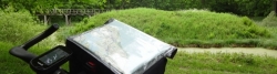
Actions
![]()
Please wait - map data are loading
Added on 27 May 2019,
on 31 May 2019
Actions
Cycle route metrics
planned
ridden
Total distance in km
195
195
Cumulative elevation gain in m
1.811
1.691
Avg. slope uphill in %
0,93
0,87
Cumulative elevation loss in m
1.813
1.789
Information about rights to the gps-track data | |
|---|---|
Rights owner | |
Rights characteristic / license | cc0: Public Domain no Rights reserved |
Link to the description of the license | |
GPX file uploaded | by Ottocolor on 31 May 2019
|
Track points in total
2.816
2.430
Track points per km (avg)
12
12
Start/endpoint
Start location
Odense, Region of Southern Denmark, DK (12 m NHN)
End location
Odense, Region of Southern Denmark, DK (10 m NHN)
Character
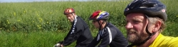
The annual bikeweekend together with my brothers was planned by Michael in Holm on Northern Als, which is our home island. His home was the goal of our first stage. We met at Fynshav, where I had cycled and sailed. The second stage took place on Nothern Als and by way of a short ferry crossing of the Als fiord in Sundeved (Jutland) and again on Als, in the land of our childhood, Soenderborg and its suburbs of Ulkeboel and Spang and finally at Madeskov campsite. The common part of the bike weekend was closed by a trip across central Als to the initial point of Fynshav. Along the way Michael and I "climbed" Hoegebjerg (81 m.a.s.l.). Now remained only a ferry crossing to Funen and a wet bike tour to Odense and my home in the suburb of Naesby.
Information about copyright | |
|---|---|
Rights characteristic / license | by-sa: CREATIVE COMMONS Attribution-ShareAlike |
Link to the description of the license | |
taken over / edited on | 27 May 2019
|
taken over / edited by |
|
Landscape
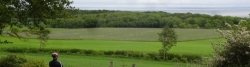
Metropolitan area on Funen followed by geest land with eskers like Sallinge esker and the quite hilly moraine landscape of Svanninge bakker. On Als and in Sundeved we cycled through coastal forests and more hills of glaical origin with views to fiords and the Als sound. The geographical climax was the hill of Hoegebjerg, near Fynshav, the highest point of the eastern Als ridge of hills. I took the same route across Funen, however with the hills "from the bottom" and therefore with steeper climbs. They're divided into three parts, which I call "the appetizer, the main dish and the dessert", as the climb in the middle is by far the worst. Altogether the terrain rises about 100 m over a distance of about 6 km from Millinge to Ny Stenderup.
Information about copyright | |
|---|---|
Rights characteristic / license | by-sa: CREATIVE COMMONS Attribution-ShareAlike |
Link to the description of the license | |
taken over / edited on | 27 May 2019
|
taken over / edited by |
|
Stages
Beds4Cyclists, worth visiting and infrastructure
Name and address
Latitude / Longitude
Phone
Fax
Mobile
Type of accommodation
Rating for cyclists
Route km
Dist. to route
Elevation
101 km
1,2 km
26 m
131 km
0,2 km
20 m
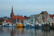
Sønderborg (Danish pronunciation: [ˈsønɐˌb̥ɒːˀ] - is a Danish town of Region of Southern Denmark. It is the main town and the administrative seat of Sønderborg Municipality. The town has a population of 27,304 (1 January 2012),in a municipality of 76,793.
The town of Sønderborg is home to Sønderborg Castle ![]() (Sønderborg Slot), the Royal Danish Army
(Sønderborg Slot), the Royal Danish Army ![]() 's Sergeant School and Sandbjerg Estate (Sandbjerg Gods, Sundeved
's Sergeant School and Sandbjerg Estate (Sandbjerg Gods, Sundeved ![]() ) near Sønderborg. Sønderborg castle is in the centre of the town, and houses a museum focusing on the history and culture of the area. The museum is open all year. Sandbjerg Estate, which had belonged for many years to the Dukes of Sønderborg, and then to the Reventlow family, was donated toAarhus University
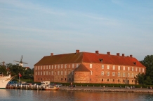
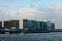
) near Sønderborg. Sønderborg castle is in the centre of the town, and houses a museum focusing on the history and culture of the area. The museum is open all year. Sandbjerg Estate, which had belonged for many years to the Dukes of Sønderborg, and then to the Reventlow family, was donated toAarhus University ![]() in 1954. In addition Sønderborg has a castle-like barracks built by the German military in 1906, placed centrally by Als Fjord, opposite Alsion (see picture below). Today the barracks is the home the Danish army NCO school.
in 1954. In addition Sønderborg has a castle-like barracks built by the German military in 1906, placed centrally by Als Fjord, opposite Alsion (see picture below). Today the barracks is the home the Danish army NCO school.
The old part of Sønderborg is on the island of Als ![]() , but some of its western suburbs
, but some of its western suburbs ![]() have spread onto the mainland of Jutland
have spread onto the mainland of Jutland ![]() into what had been the interior of the fort of Dybbøl
into what had been the interior of the fort of Dybbøl ![]() .
.
History
Prior to the Second Schleswig War ![]() of 1864, Sønderborg was situated in the Duchy of Schleswig
of 1864, Sønderborg was situated in the Duchy of Schleswig ![]() , a Danish fief
, a Danish fief ![]() , so its history is properly included in the contentious history of Schleswig-Holstein. In the 1920 Schleswig Plebiscite
, so its history is properly included in the contentious history of Schleswig-Holstein. In the 1920 Schleswig Plebiscite ![]() that returned Northern Schleswig
that returned Northern Schleswig ![]() to Denmark, 43.8% of the city of Sønderborg's inhabitants voted for the cession to Denmark and 56.2% voted for remaining part of Germany.
to Denmark, 43.8% of the city of Sønderborg's inhabitants voted for the cession to Denmark and 56.2% voted for remaining part of Germany.
The town of Sønderborg lies on both sides of Alssund; the narrow strait between these two sides is called Als Strait (Alssund). Two road bridges connect the city across the strait: the 682-meter Als Strait Bridge (Alssundbro), built in 1978-1981; and the 331-meter King Christian X ![]() 's Bridge (Kong Christian Xs Bro), built in 1925-1930.
's Bridge (Kong Christian Xs Bro), built in 1925-1930.
Information about copyright | |
|---|---|
Rights characteristic / license | by-sa: CREATIVE COMMONS Attribution-ShareAlike |
Link to the description of the license | |
Input taken over from: |
Sønderborg. (2013, February 21). In Wikipedia, The Free Encyclopedia. Retrieved 15:37, April 15, 2013, from http://en.wikipedia.org/w/index.php?title=S%C3%B8nderborg&oldid=539542484 |
taken over / edited on | 15 Apr 2013
|
taken over / edited by |
|
Hours of opening
Opening hours 02-01-2013 - 23-12-2013Monday- Friday10:00 - 17:00 02-01-2013 - 23-12-2013Saturday10:00 - 13:00 24-06-2013 - 11-08-2013Saturday10:00- 14:00
133 km
0,2 km
30 m
Hours of opening
Mo-Fr: 10:00 - 16:00
Mo-Fr: 10:00 - 15:00
Mo-Fr: 10:00 - 15:00
Mo-Fr: 10:00 - 16:00
Sa:10:00 - 13:00
Sa:10:00 - 13:00
Sa: 10:00 - 13:00
Sa: 10:00 - 13:00
133 km
1,9 km
7 m
134 km
0,2 km
22 m
![]()