Cycle Tour Bike holiday The Upper Rhine
Dag/day 5: Chur-Triesen
![]()
Please wait - map data are loading
Added on 24 Jul 2020
last edited by Ottocolor on 06 Aug 2020
Cycle route metrics
ridden
Total distance in km
41
Cumulative elevation gain in m
199
Avg. slope uphill in %
0,49
Cumulative elevation loss in m
222
Min. height
484
Max. height
577
Information about rights to the gps-track data | |
|---|---|
Rights owner | |
Rights characteristic / license | cc0: Public Domain no Rights reserved |
Link to the description of the license | |
GPX file uploaded | by Ottocolor on 24 Jul 2020
|
Track points in total
628
Track points per km (avg)
15
Start/endpoint
Start location
Chur, Graubünden, CH (536 m NHN)
End location
Triesen, LI (514 m NHN)
ridden on
12 Jul 2020
Weather
Short stage in perfect weather. Sunshine and not too hot. about 22 to 23°C. A light headwind doesn't slow us significantly. Even late in the evening in Vaduz it's still nice and warm.
Accommodation
Camping Mittagsspitze
Sägastrasse 29
LI-9495 Triesen
Properties
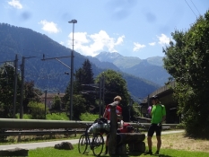
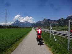
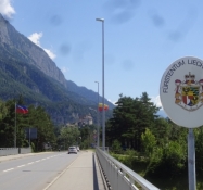
The vast majority of the stage runs on a broad, even bike road along the river. Once we skip the Rhine up its tributary Landquart. Afterwards comes an okay gravel stretch. In Liechtenstein we go on bike lanes along roads and in the end a small road without bike lane.
Slope Gradient Distribution
Remarks
Short and easy stage out of Switzerland and into Liechtenstein.
Travel report
Information about copyright | |
|---|---|
Rights owner | |
Rights characteristic / license | by-sa: CREATIVE COMMONS Attribution-ShareAlike |
Link to the description of the license | |
Image has been uploaded | by Ottocolor on 04 Aug 2020
|
Information about copyright | |
|---|---|
Rights owner | |
Rights characteristic / license | by-sa: CREATIVE COMMONS Attribution-ShareAlike |
Link to the description of the license | |
Image has been uploaded | by Ottocolor on 04 Aug 2020
|
Information about copyright | |
|---|---|
Rights owner | |
Rights characteristic / license | by-sa: CREATIVE COMMONS Attribution-ShareAlike |
Link to the description of the license | |
Image has been uploaded | by Ottocolor on 04 Aug 2020
|
Information about copyright | |
|---|---|
Rights owner | |
Rights characteristic / license | by-sa: CREATIVE COMMONS Attribution-ShareAlike |
Link to the description of the license | |
Image has been uploaded | by Ottocolor on 04 Aug 2020
|
Information about copyright | |
|---|---|
Rights owner | |
Rights characteristic / license | by-sa: CREATIVE COMMONS Attribution-ShareAlike |
Link to the description of the license | |
Image has been uploaded | by Ottocolor on 04 Aug 2020
|
Information about copyright | |
|---|---|
Rights owner | |
Rights characteristic / license | by-sa: CREATIVE COMMONS Attribution-ShareAlike |
Link to the description of the license | |
Image has been uploaded | by Ottocolor on 04 Aug 2020
|
Information about copyright | |
|---|---|
Rights owner | |
Rights characteristic / license | by-sa: CREATIVE COMMONS Attribution-ShareAlike |
Link to the description of the license | |
Image has been uploaded | by Ottocolor on 04 Aug 2020
|
Information about copyright | |
|---|---|
Rights owner | |
Rights characteristic / license | by-sa: CREATIVE COMMONS Attribution-ShareAlike |
Link to the description of the license | |
Image has been uploaded | by Ottocolor on 04 Aug 2020
|
Information about copyright | |
|---|---|
Rights owner | |
Rights characteristic / license | by-sa: CREATIVE COMMONS Attribution-ShareAlike |
Link to the description of the license | |
Image has been uploaded | by Ottocolor on 04 Aug 2020
|

