
Cycle Tour Bike weekend 2014
Travel report: Næsby-Egernsund-Damp-Eckernförde-Damp-Høruphav-Næsby
Actions
![]()
Please wait - map data are loading
Added on 22 May 2014,
last edited by Ottocolor on 01 Jun 2014
Actions
Cycle route metrics
planned
ridden
Total distance in km
86
199
Cumulative elevation gain in m
1.550
1.519
Avg. slope uphill in %
1,80
0,76
Cumulative elevation loss in m
1.551
1.524
Information about rights to the gps-track data | |
|---|---|
Rights owner | |
Rights characteristic / license | by-sa: CREATIVE COMMONS Attribution-ShareAlike |
Link to the description of the license | |
GPX file uploaded | by Ottocolor on 31 May 2014
|
Track points in total
3.649
2.334
Track points per km (avg)
11
12
Start/endpoint
Start location
Odense, Region Syddanmark, DK (11 m NHN)
End location
Odense, Region Syddanmark, DK (10 m NHN)
Stages
Information about copyright | |
|---|---|
Rights owner | |
Rights characteristic / license | by-sa: CREATIVE COMMONS Attribution-ShareAlike |
Link to the description of the license | |
Image has been uploaded | by Ottocolor on 31 May 2014
|
86 km
Næsby-Egernsund-Damp
Information about copyright | |
|---|---|
Rights owner | |
Rights characteristic / license | by-sa: CREATIVE COMMONS Attribution-ShareAlike |
Link to the description of the license | |
Image has been uploaded | by Ottocolor on 31 May 2014
|
49 km
Damp-Eckernförde-Damp
Information about copyright | |
|---|---|
Rights owner | |
Rights characteristic / license | by-sa: CREATIVE COMMONS Attribution-ShareAlike |
Link to the description of the license | |
Image has been uploaded | by Ottocolor on 31 May 2014
|
64 km
Damp-Høruphav-Næsby
Beds4Cyclists, worth visiting and infrastructure
Name and address
Latitude / Longitude
Phone
Fax
Mobile
Type of accommodation
Rating for cyclists
Route km
Dist. to route
Elevation
78 km
0,9 km
14 m
Information about copyright | |
|---|---|
Rights owner | https://commons.wikimedia.org/w/index.php?title=User:PodracerHH |
Rights characteristic / license | cc0: Public Domain no Rights reserved |
Link to the description of the license | |
Image taken over from | https://commons.wikimedia.org/wiki/File:Augustenborg_Gartenfassade.JPG |
Image has been uploaded | by ThimbleU on 30 Sep 2019
|
Information about copyright | |
|---|---|
Rights owner | https://commons.wikimedia.org/w/index.php?title=User:PodracerHH |
Rights characteristic / license | cc0: Public Domain no Rights reserved |
Link to the description of the license | |
Image taken over from | https://commons.wikimedia.org/wiki/File:Augustenborg_Torhaus.JPG |
Image has been uploaded | by ThimbleU on 30 Sep 2019
|
Information about copyright | |
|---|---|
Rights owner | |
Rights characteristic / license | by-sa: CREATIVE COMMONS Attribution-ShareAlike |
Link to the description of the license | |
Image taken over from | https://commons.wikimedia.org/wiki/File:Augustenborg_Slotskirkes_kor.jpeg |
Image has been uploaded | by ThimbleU on 30 Sep 2019
|
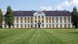
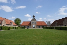
Augustenborg Palace (or Augustenborg Castle; Danish: Augustenborg Slot, German: Schloss Augustenburg) is a Rococo-style palace in the southwestern part of Augustenborg ![]() , Als Island, Denmark, overlooking Augustenborg Fjord. The palace owes its name to Duchess Auguste (1633–1701). Augustenborg gave its name to the House of Schleswig-Holstein-Sonderburg-Augustenburg, the last member of which was Duke Christian August II (1798–1869).
, Als Island, Denmark, overlooking Augustenborg Fjord. The palace owes its name to Duchess Auguste (1633–1701). Augustenborg gave its name to the House of Schleswig-Holstein-Sonderburg-Augustenburg, the last member of which was Duke Christian August II (1798–1869).
History
The original half-timbered manor house was built in 1660-4 by Ernest Günther, the first Duke of Augustenborg, after he bought the village of Stavensbøl and demolished it for the land. The one-storey, red-roofed buildings around the outer courtyard were added from 1733 while the main three-winged building, replacing the original manor, was built from 1770 to 1776 in full symmetry, a fine example of Baroque architecture.
With its yellow-painted walls and blue-tiled roof, the wings gradually increase in height up to the central section. The three central bays of the facade protrude as an avant-corps three storeys high. Inside a beautiful entrance hall was finished in white-painted stucco by the Italian decorator Michel Angelo Taddei (1755–1831). Taddei also worked on the interior of the two-storey Baroque chapel in the building's northern wing, adding a Rococo altarpiece with an integrated pulpit as well as decorations along the vaults and walls of the nave. During the same period, much of the town was regenerated. The palace building underwent further renovation in the 1920s. Hans Christian Andersen spent two weeks at the palace in the autumn of 1844 and wrote The Little Match Girl when he visited the castle.
During the First Schleswig War (1848–50), Christian August II, the last duke to live in the palace, left Augustenborg as a result of his close relations with Germany. Thereafter the building was first used as a barracks and from 1878 as a seminary for women.
In 1921, Augustenborg was purchased by the Danish state. It was fitted out as a hospital in 1927–28 and since 1932 has been used as a psychiatric hospital. There is an exhibit about the palace, the town and its ducal history in the building's entryway.
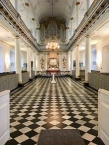
Church
The largest room in the castle is the church hall, which dates from the late 18th century. Not visible from the outside, it covers the entire two-storey annexe of the north wing and is the successor of an older chapel, from 1671, which was demolished before the construction of the castle. The hall, which has served as the parish church of the town since 1874, was extensively restored in 1972.
The rococo architecture of the church hall is consistent with the rest of the building. The stucco work was probably designed by Michelangelo Taddei. The hall has seven divided window bays. Six Doric and six Corinthian columns separate the room, forming a three-aisled hall. A curved balustrade leads to the pulpit altar on the eastern wall. The organ is placed over the high altar and was built by the Holstein organ builder, Johann Daniel Busch. The Carrara marble baptismal font was a gift of the Russian Tsar Alexander I.
Information about copyright | |
|---|---|
Rights characteristic / license | by-sa: CREATIVE COMMONS Attribution-ShareAlike |
Link to the description of the license | |
Input taken over from: |
Wikipedia contributors, 'Augustenborg Palace', Wikipedia, The Free Encyclopedia, 27 September 2019, 06:06 UTC, https://en.wikipedia.org/w/index.php?title=Augustenborg_Palace&oldid=918135698 [accessed 30 September 2019] |
taken over / edited on | 30 Sep 2019
|
taken over / edited by |
|
79 km
0,9 km
9 m
80 km
0,1 km
13 m
84 km
0,8 km
22 m
85 km
1,4 km
7 m
![]()