
Cycle Tour Cabo St. Vincente - Labenne
Travel report
Actions
![]()
Please wait - map data are loading
Added on 24 Oct 2012,
last edited by biroto-Redaktion on 30 Aug 2023
Actions
Cycle route metrics
planned
ridden
Total distance in km
1.606
0
Cumulative elevation gain in m
18.325
0
Avg. slope uphill in %
1,14
-
Cumulative elevation loss in m
18.349
0
Information about rights to the gps-track data | |
|---|---|
Rights owner | 2PeopleCycling.com | Jan-Willem & Saskia |
Rights characteristic / license | by-sa: CREATIVE COMMONS Attribution-ShareAlike |
Link to the description of the license | |
GPX file taken from | www.2peoplecycling.com/fietsroutes/atlantic-coast-route/gps-tracks/ |
GPX file uploaded | by biroto-Redaktion on 25 Oct 2012
|
Track points in total
17.859
0
Track points per km (avg)
11
0
Start/endpoint
Start location
Sagres, Algarve, PT (32 m NHN)
End location
Labenne, Aquitanien, FR (8 m NHN)
Sources of information
For more information about the tour, which was cycled as part of the Atlantic Coast Route in 2011, please look on 2PeopleCycling Atlantic Coast Route.
Ideas for this tour are taken from
- Silver Route (in Dutch)
- St. Jacobsroute (in Dutch)
Connecting cycle path
- Labenne Atlantic Coast Route - Part Wales to Portugal (EV1)
Beds4Cyclists, worth visiting and infrastructure
Name and address
Latitude / Longitude
Phone
Fax
Mobile
Type of accommodation
Rating for cyclists
Route km
Dist. to route
Elevation
0 km
0,0 km
20 m
Information about copyright | |
|---|---|
Rights owner | |
Rights characteristic / license | by: CREATIVE COMMONS Attribution |
Link to the description of the license | |
Image taken over from | commons.wikimedia.org/wiki/File:SavesPortugalMaxSouthWestOfEurope2010.jpg |
Image has been uploaded | by biroto-Redaktion on 30 Oct 2012
|

Information about copyright | |
|---|---|
Rights owner | |
Rights characteristic / license | by-sa: CREATIVE COMMONS Attribution-ShareAlike |
Link to the description of the license | |
Image taken over from | commons.wikimedia.org/wiki/File:Leuchtturm_-_Sagres_20060422.JPG |
Image has been uploaded | by biroto-Redaktion on 30 Oct 2012
|
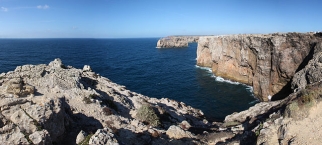
Cape St. Vincent (Portuguese: Cabo de São Vicente, Portuguese pronunciation: [ˈkabu dɨ sɐ̃w̃ viˈsẽtɨ]), next to the Sagres Point ![]() , on the so-called Costa Vicentina (Vincentine Coast), is a headland in the municipality of Sagres
, on the so-called Costa Vicentina (Vincentine Coast), is a headland in the municipality of Sagres ![]() , in the Algarve, southern Portugal.
, in the Algarve, southern Portugal.
Cape St. Vincent was already sacred ground in Neolithic times, as standing menhirs in the neighborhood attest. The ancient Greeks called it Ophiussa (Land of Serpents), inhabited by the Oestriminis and dedicated here a temple to Heracles. The Romans called it Promontorium Sacrum (or Holy Promontory). They considered it a magical place where the sunset was much larger than anywhere else. They believed the sun sank here hissing into the ocean, marking the edge of their world.
The present lighthouse was built over the ruins of a 16th century Franciscan convent in 1846. The statues of St. Vincent and St. Francis Xavier had been moved to the nearby church of Nossa Senhora da Graça on Point Sagres.
This lighthouse, guarding one of the world's busiest shipping lanes, is among the most powerful in Europe (the most powerful being on the French island of Ushant, off the coast of Brittany); its two 1,000 W lamps can be seen as far as 60 kilometers away.
Information about copyright | |
|---|---|
Rights characteristic / license | by-sa: CREATIVE COMMONS Attribution-ShareAlike |
Link to the description of the license | |
Input taken over from: |
Wikipedia contributors, 'Cape St. Vincent', Wikipedia, The Free Encyclopedia, 5 June 2012, 19:29 UTC, http://en.wikipedia.org/w/index.php?title=Cape_St._Vincent&oldid=496159847 [accessed 29 October 2012] |
taken over / edited on | 30 Oct 2012 - 24 May 2013
|
taken over / edited by |
|
41 km
0,3 km
15 m
Information about copyright | |
|---|---|
Rights owner | |
Rights characteristic / license | by-sa: CREATIVE COMMONS Attribution-ShareAlike |
Link to the description of the license | |
Image taken over from | |
Image has been uploaded | by biroto-Redaktion on 30 Oct 2012
|
Information about copyright | |
|---|---|
Rights owner | |
Rights characteristic / license | by-sa: CREATIVE COMMONS Attribution-ShareAlike |
Link to the description of the license | |
Image taken over from | |
Image has been uploaded | by biroto-Redaktion on 30 Oct 2012
|
Information about copyright | |
|---|---|
Rights owner | |
Rights characteristic / license | by-sa: CREATIVE COMMONS Attribution-ShareAlike |
Link to the description of the license | |
Image taken over from | commons.wikimedia.org/wiki/File:Dona_Ana_Beach_Lagos_Algarve_Portugal.png |
Image has been uploaded | by biroto-Redaktion on 30 Oct 2012
|
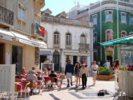
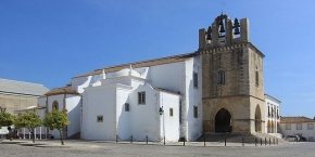
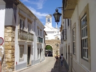
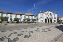
Faro ['faɾu] ist eine Stadt im Süden Portugals (Algarve).
Die Stadt verfügt über zahlreiche Sehenswürdigkeiten, u. a. die „goldene“ Barockkarmeliterkirche Nossa Senhora do Carmo aus dem 18. Jahrhundert, deren schaurige Attraktion die Capela dos Ossos, die mit Schädeln und Knochen verzierte Knochenkapelle ist. Durch den Arco da Vila oder den Arco do Repousado gelangt man in die Altstadt, die Vila Adentro, in der sich die Kathedrale Sé aus dem 13. Jahrhundert am Largo da Sé und das Rathaus befindet. Das ehemalige Kloster Nossa Senhora da Assunção aus dem 16. Jahrhundert verfügt über einen schönen Renaissance-Kreuzgang und dient seit 1973 als archäologisches Museum, in dem u.a. Exponate aus dem nahegelegenen römischen Milreu ![]() , aber auch Azulejos
, aber auch Azulejos ![]() und sakrale Kunst und Malerei gezeigt werden. Am Hafen im Gebäude des Hafenmeisters befindet sich das Museu Marítimo, ein Schifffahrtsmuseum, in dem historische Schiffsmodelle und Fischfangmethoden der Algarve präsentiert werden. Im Gebäude der Bezirksverwaltung ist das ethnographische Museu Regional untergebracht. Zusammen mit Fotos über die Lebens- und Wohnverhältnisse sind hier kunsthandwerkliche Gegenstände, Trachten und detailgetreue Modelle der gesamten Algarve zusammengetragen.
und sakrale Kunst und Malerei gezeigt werden. Am Hafen im Gebäude des Hafenmeisters befindet sich das Museu Marítimo, ein Schifffahrtsmuseum, in dem historische Schiffsmodelle und Fischfangmethoden der Algarve präsentiert werden. Im Gebäude der Bezirksverwaltung ist das ethnographische Museu Regional untergebracht. Zusammen mit Fotos über die Lebens- und Wohnverhältnisse sind hier kunsthandwerkliche Gegenstände, Trachten und detailgetreue Modelle der gesamten Algarve zusammengetragen.
Information about copyright | |
|---|---|
Rights characteristic / license | by-sa: CREATIVE COMMONS Attribution-ShareAlike |
Link to the description of the license | |
Input taken over from: |
Seite „Faro“. In: Wikipedia, Die freie Enzyklopädie. Bearbeitungsstand: 7. Oktober 2012, 20:36 UTC. URL: http://de.wikipedia.org/w/index.php?title=Faro&oldid=109035076 (Abgerufen: 29. Oktober 2012, 23:11 UTC) |
taken over / edited on | 30 Oct 2012
|
taken over / edited by |
|
150 km
0,3 km
10 m
150 km
0,6 km
22 m
Information about copyright | |
|---|---|
Rights owner | |
Rights characteristic / license | by-sa: CREATIVE COMMONS Attribution-ShareAlike |
Link to the description of the license | |
Image taken over from | https://commons.wikimedia.org/wiki/File:Faro-Kathedrale-1-bis.jpg |
Image has been uploaded | by biroto-Redaktion on 02 Aug 2016
|
Information about copyright | |
|---|---|
Rights owner | |
Rights characteristic / license | by-sa: CREATIVE COMMONS Attribution-ShareAlike |
Link to the description of the license | |
Image taken over from | https://commons.wikimedia.org/wiki/File:Arco_da_vila_2016_2.jpg |
Image has been uploaded | by biroto-Redaktion on 02 Aug 2016
|
Information about copyright | |
|---|---|
Rights owner | |
Rights characteristic / license | by-sa: CREATIVE COMMONS Attribution-ShareAlike |
Link to the description of the license | |
Image taken over from | https://commons.wikimedia.org/wiki/File:Faro_Cidade_Velha_2.JPG |
Image has been uploaded | by biroto-Redaktion on 02 Aug 2016
|
Information about copyright | |
|---|---|
Rights owner | |
Rights characteristic / license | by-sa: CREATIVE COMMONS Attribution-ShareAlike |
Link to the description of the license | |
Image taken over from | https://commons.wikimedia.org/wiki/File:Faro-Bischofspalast-Rathaus.jpg |
Image has been uploaded | by biroto-Redaktion on 02 Aug 2016
|
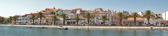
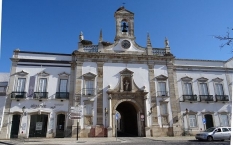
Faro (Portuguese pronunciation: [ˈfaɾu]) is a municipality, southernmost city and seat of the district of the same name, in the Algarve region of southern Portugal. With a population of 64,560 inhabitants in 2011 (with 50,000 inhabitants in the city proper), the municipality covers an area of approximately 202.57 square kilometres (78.21 square miles).
Information about copyright | |
|---|---|
Rights characteristic / license | by-sa: CREATIVE COMMONS Attribution-ShareAlike |
Link to the description of the license | |
Input taken over from: |
Wikipedia contributors, 'Faro, Portugal', Wikipedia, The Free Encyclopedia, 25 July 2016, 10:47 UTC, <https://en.wikipedia.org/w/index.php?title=Faro,_Portugal&oldid=731438332> [accessed 2 August 2016] |
taken over / edited on | 02 Aug 2016
|
taken over / edited by |
|
186 km
0,5 km
6 m
Information about copyright | |
|---|---|
Rights owner | https://commons.wikimedia.org/w/index.php?title=User:Valternet |
Rights characteristic / license | by-sa: CREATIVE COMMONS Attribution-ShareAlike |
Link to the description of the license | |
Image taken over from | |
Image has been uploaded | by biroto-Redaktion on 20 Aug 2016
|
Information about copyright | |
|---|---|
Rights owner | |
Rights characteristic / license | by-sa: CREATIVE COMMONS Attribution-ShareAlike |
Link to the description of the license | |
Image taken over from | https://commons.wikimedia.org/wiki/File:Cidade_de_Tavira.jpg |
Image has been uploaded | by biroto-Redaktion on 20 Aug 2016
|
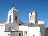
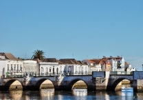
Tavira ist eine Stadt an der Algarve ![]() .
.
Hintergrund
Die Stadt liegt in der östlichen Algarve, rund 20 Kilometer von der spanischen Grenze entfernt, am Ufer des Rio Gilão, kurzz vor dessen Mündung in den Atlantischer Ozean. Zwischen der Stadt und dem Meer liegen einige Salinen. Die Fischerei hat nicht mehr ihre frühere Bedeutung, war sie doch einmal das Zentrum des Thunfischfangs an der Küste der Algarve.
Die Stadt ist sehr alt und wurde vermutlich bereits von den Phöniziern gegründet. Die Römer ließen sich nicht direkt hier nieder, sondern ein paar Kilometer weiter westlich und nannten ihre Siedlung Balsa, von der allerdings nur noch wenige Reste vorhanden sind. Lange Zeit war die siebenbogige, im Volksmund den Römern zugeschriebene Brücke die einzige Verbindung der beiden Flussufer.
Unter den Arabern wurde die Stadt Tabira genannt. Zu dieser Zeit war der Hafen ein wichtiger Handelsplatz. 1242 eroberten die Portugiesen die Stadt, und sie wurde zum Stützpunkt für die nordafrikanischen Kolonien. Nachdem diese aufgegeben werden mussten, verlor der Hafen, der zugleich begann zu versanden, an Bedeutung.
Nach der Herrschaft der Spanier zwischen 1508 und 1640, wütete 1645/46 eine Pestepidemie in der Stadt. Von diesen Schicksalschlägen, und vor allem vom Erbeben, das 1755 große Teile der Stadt zerstörte, erholte sich die Stadt nicht und sie blieb relativ bedeutungslos.
Sehenswürdigkeiten
Durch das Erdbeben von 1755 sind nur sehr wenige Bauten älter als 250 Jahre. Allerdings erhielt die Stadt dadurch eine recht einheitliche Bauweise. Vor allem die Walmdachform der alten Häuser ist sehenswert.
Kirchen
- ⊙Igreja da Misericódia − Kirche der Barmherzigkeit
- blau und weiß glasierte Azulejos
- kunstvoll geschnitzter Altar
- ⊙Igreja Santa Maria do Castelo
- Igreja de São Paulos
Burgen, Schlösser und Paläste
- Die Ruinen des Kastells ⊙Castro Mouros aus der Zeit König Dinis (1261-1325).
Bauwerke
- Bei der ⊙Römerbrücke: Ponte Pomana über den Fluss Gilão, handelt es sich keinesfalls um eine römische Brücke. Belegt ist die Brücke erst ab dem Mittelalter. Ob es hier je einen römischen Bau gab, ist ungewiss. Die mittelalterliche Brücke wurde beim Erdbeben von 1755 zerstört, die heutige ist also eine Rekonstruktion aus dem 18. Jahrhundert.
- Die alte Markthalle von 1887. Sie wird nicht mehr als Markthalle genutzt, sondern beherbergt heute Läden und Gastronomiebetriebe.
Information about copyright | |
|---|---|
Rights characteristic / license | by-sa: CREATIVE COMMONS Attribution-ShareAlike |
Link to the description of the license | |
Input taken over from: |
Wikivoyage-Bearbeiter, 'Tavira', Wikivoyage, Freie Reiseinformationen rund um die Welt, 13. August 2016, 15:31 UTC, <https://de.wikivoyage.org/w/index.php?title=Tavira&oldid=947914> [abgerufen am 20. August 2016] |
taken over / edited on | 20 Aug 2016 - 20 Sep 2016
|
taken over / edited by |
|
![]()