
Cycle Tour Canal des 2 mers - Mediterranean route - Cycle route Switzerland-Mediterranean
1. Etappe: Bordeaux - La Réole - Sainte-Marthe
![]()
Please wait - map data are loading
Added on 13 Jun 2018
last edited by ThimbleU on 22 Aug 2018
Cycle route metrics
ridden
Total distance in km
101
Cumulative elevation gain in m
589
Avg. slope uphill in %
0,58
Cumulative elevation loss in m
583
Total cycling hours
5,8
Avg. pace in km/h
17,4
Min. height
9
Max. height
107
Information about rights to the gps-track data | |
|---|---|
Rights owner | |
Rights characteristic / license | cc0: Public Domain no Rights reserved |
Link to the description of the license | |
GPX file uploaded | by ThimbleU on 16 Jun 2018
|
Track points in total
1.543
Track points per km (avg)
15
Start/endpoint
Start location
Bordeaux, New Aquitaine, FR (17 m NHN)
End location
Fourques-sur-Garonne, New Aquitaine, FR (23 m NHN)
ridden on
16 Jun 2018
Weather
Cloudy until 3 pm, then clear to cloudy.
Accommodation
Chambres dʹhôtes Moulin de Tarres de Bas
Lieu-dit Barron
FR-47430 Fourques-sur-Garonne
Signposting
Well signposted as cycle path V80 "le canal de 2 mers à vélo" |
|

Properties
asphalt | 101 km | 100 % |
The information relates to the track as traveled!
Slope Gradient Distribution
Travel report
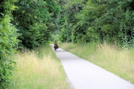
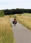
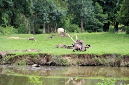
From the accommodation we cycled less than 1.5 km to the banks of the Garonne. The "beautiful" riverbank of Bordeaux is not photogenic enough for a picture in today's light conditions. We cycled for eight kilometers along the road on the northern bank of the Garonne. The height is almost constant. The water level of the Garonne is only half a meter below the embankment. After four and a half kilometers we left the main road. On the smaller street there were several "stately" estates. Then we turned off the bank and after another kilometer we reached the rail trail on a disused railway line.
Information about copyright | |
|---|---|
Rights characteristic / license | by-sa: CREATIVE COMMONS Attribution-ShareAlike |
Link to the description of the license | |
taken over / edited on | 21 Aug 2018 - 22 Aug 2018
|
taken over / edited by |
|
Information about copyright | |
|---|---|
Rights owner | |
Rights characteristic / license | © all rights reserved. |
Image has been uploaded | by ThimbleU on 22 Aug 2018
|
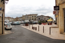
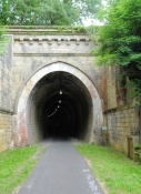
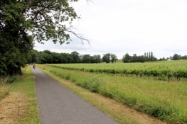
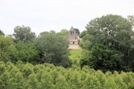
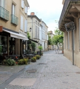
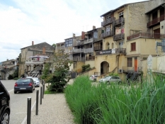
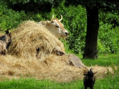
With a slight slope, it was now 12 kilometers uphill to the former Bastide Créon at about 100 meters altitude. We cycled into the village and provided ourselves at the main square with fruit and baked goods. Back on the rail trail, we rolled now downhill. Four kilometers further we passed La Sauve. The outline of the former abbey "Abbaye de La Sauve-Majeure", listed as a World Heritage Site, we saw less than a kilometer away. Next we cycled through a tunnel for 300 meters. After that, it was going downhill for almost four kilometers. On this piece on both sides of the route the vineyards begun. By the end of the next ascent, these are spreading almost to the horizon. This has not change in the next 20 kilometers. Then we reached Saufterre-de-Guyenne. Here ends the rail trail.
Information about copyright | |
|---|---|
Rights characteristic / license | by-sa: CREATIVE COMMONS Attribution-ShareAlike |
Link to the description of the license | |
taken over / edited on | 22 Aug 2018
|
taken over / edited by |
|
Through the still-preserved gate we cycled into the former Bastide, up the hill to the main square. This is similar to the one in Créon. At the end of the square we turned southeast and left the village. Less than a kilometer ahead, after a short downhill, it was about 15 meters uphill. A taste of the following ups and downs to La Réole.
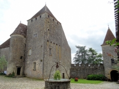
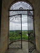
Vineyards were again on both sides of the way. In the area of Loubens, the signposted route differed from the planned route (and from the one on OSM). It went neatly uphill to the left, a total of almost 50 meters in altitude. Shortly after, we passed the Château de Lavison, a 13th-century castle-like building complex.
Information about copyright | |
|---|---|
Rights characteristic / license | by-sa: CREATIVE COMMONS Attribution-ShareAlike |
Link to the description of the license | |
taken over / edited on | 22 Aug 2018
|
taken over / edited by |
|
Information about copyright | |
|---|---|
Rights owner | |
Rights characteristic / license | © all rights reserved. |
Image has been uploaded | by ThimbleU on 22 Aug 2018
|
Information about copyright | |
|---|---|
Rights owner | |
Rights characteristic / license | © all rights reserved. |
Image has been uploaded | by ThimbleU on 22 Aug 2018
|

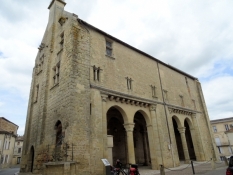
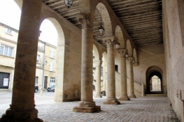
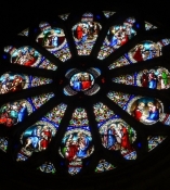
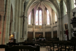
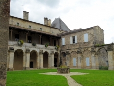
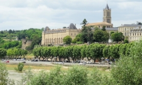
Until La Réole, there were again some ups and downs in elevation to deal with. At the beginning of the old town we came across the town hall, which must have existed already around 1190 and is considered to be the oldest preserved town hall of France. Richard the Lionheart held a congregation of secular and ecclesiastical rulers of Angleterre around 1190 to have them well-intentioned through rewards and concessions during his absence. Also worth seeing in the medieval old town was the monastery church.
Information about copyright | |
|---|---|
Rights characteristic / license | by-sa: CREATIVE COMMONS Attribution-ShareAlike |
Link to the description of the license | |
taken over / edited on | 22 Aug 2018
|
taken over / edited by |
|
Information about copyright | |
|---|---|
Rights owner | |
Rights characteristic / license | © all rights reserved. |
Image has been uploaded | by ThimbleU on 22 Aug 2018
|
Information about copyright | |
|---|---|
Rights owner | |
Rights characteristic / license | © all rights reserved. |
Image has been uploaded | by ThimbleU on 22 Aug 2018
|
Information about copyright | |
|---|---|
Rights owner | |
Rights characteristic / license | © all rights reserved. |
Image has been uploaded | by ThimbleU on 22 Aug 2018
|
Information about copyright | |
|---|---|
Rights owner | |
Rights characteristic / license | © all rights reserved. |
Image has been uploaded | by ThimbleU on 22 Aug 2018
|
Information about copyright | |
|---|---|
Rights owner | |
Rights characteristic / license | © all rights reserved. |
Image has been uploaded | by ThimbleU on 22 Aug 2018
|
Information about copyright | |
|---|---|
Rights owner | |
Rights characteristic / license | © all rights reserved. |
Image has been uploaded | by ThimbleU on 22 Aug 2018
|
On the eastern edge of the old town we rolled down the steep hill to the road along the Garonne, which we crossed over the bridge. Shortly after taht we discovered, in addition to the signposting of the bike path "Canal des 2 mers" also logos of the EuroVelo 3 "La Scandiberique", which should not run here after the well-known planning.
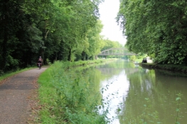
Two and a half kilometers further we reached the "Canal latéral à la Garonne". Lined by a series of plane trees on each side, the canal winds its way, mostly several meters above the surrounding terrain level, from lock to lock a few meters up, through the valley. The bike path is paved throughout. Over some of the many bridges occasionally we changed sides. The visual impression was now repeated kilometers after kilometer.
On the southwestern slopes several landslides caused by water could be seen. Once, even the bike path was rinsed out, so we have to dodge the grass strip.
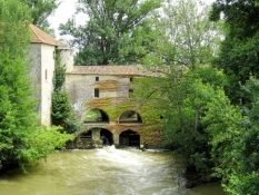
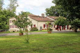
At the height of Marmande we left the channel and reached after two kilometers our Chambres d'Hôtes. Accommodation is rare in this area. Six calls from our landlord in Bordeaux were needed it this morning until we found a place to stay. The Chambres d'Hôtes is about 50 meters off the road, absolutely quiet. It is a former watermill.
Information about copyright | |
|---|---|
Rights characteristic / license | by-sa: CREATIVE COMMONS Attribution-ShareAlike |
Link to the description of the license | |
taken over / edited on | 22 Aug 2018
|
taken over / edited by |
|
Information about copyright | |
|---|---|
Rights owner | |
Rights characteristic / license | © all rights reserved. |
Image has been uploaded | by ThimbleU on 22 Aug 2018
|
In the evening we were spoiled by our landlady with a four-course meal. As Amuse-Gueule we had two kinds of salami on baguette. As an appetizer leek with mussels, with it a well-cooled rose wine. The main course was duck meat in vegetable puree, to a delicious red wine from the Bordeaux. Then a cheese selection. And finally a dessert with raspberries on a white cream. Just delicious.
Information about copyright | |
|---|---|
Rights characteristic / license | by-sa: CREATIVE COMMONS Attribution-ShareAlike |
Link to the description of the license | |
taken over / edited on | 22 Aug 2018
|
taken over / edited by |
|