Radtour Canal des 2 mers - Mittelmeer-Route - Radroute Schweiz-Mittelmeer
11. Etappe: Apt - Manosque
![]()
Bitte warten - Kartendaten werden geladen
Erstellt am 13.06.2018
zuletzt geändert von ThimbleU am 07.09.2018
Strecken-Merkmale
gefahren
Gesamtlänge in km
71
Gesamthöhenmeter Aufstieg
896
Durchschn. Steigung Aufstieg %
1,26
Gesamthöhenmeter Abstieg
787
Gesamtsattelstunden
5,0
Durchschnittsgeschwindigkeit in km/Std.
14,2
min. Höhe
223
max. Höhe
580
Informationen zu Rechten an den GPS-Track-Daten | |
|---|---|
Rechte-Inhaber | |
Rechte-Ausprägung / Lizenz | cc0: Public Domain keine Rechte vorbehalten |
Link zur Rechtebeschreibung | |
gpx-Datei hochgeladen | durch ThimbleU am 28.06.2018
|
Gesamtzahl Trackpoints
1.353
Trackpoint-Dichte per km
19
Endorte
Start
Apt, Provence-Alpes-Côte d'Azur, FR (284 m NHN)
Ziel
Manosque, Provence-Alpes-Côte d'Azur, FR (393 m NHN)
gefahren am
28.06.2018
Wetter
Frühmorgens sonnig, zunehmend wolkiger.
Unterkunft
Hôtel du Terreau
21 place du Terreau
FR-04100 Manosque
Wegweisung
Von Apt bis Dauphin und von Volx bis Manosque mit dem EuroVelo 8-Logo ausreichend für die Navigation beschildert. |
|

Beschaffenheit
Asphalt | 70,7 km | 100 % |
Die Angaben beziehen sich auf die gefahrene Strecke!
Steigungs-Verteilung
Reisebericht
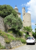
In Apt rollen wir erst einmal schwungvoll den Hügel hinunter in die Stadt und dann auf der anderen Seite zum Aufwärmen treten wir kräftig den Hang wieder hinauf bis zur Bahntrasse.
Danach radeln wir für rund zehn Kilometer ohne wesentliche Steigung das Tal des Cavalon hinauf. Auf Höhe der D48 hört die Bahntrasse auf und es geht auf dem Autour des Louberon à Vélo als provisorische Wegführung für den EV8 weiter. Ein wenig hinunter zur Talsohle und dann 50m Höhenmeter hinauf.
Informationen zu Urheber-Rechten | |
|---|---|
Rechte-Ausprägung / Lizenz | by-sa: CREATIVE COMMONS Namensnennung, Weitergabe unter gleichen Bedingungen |
Link zur Rechtebeschreibung | |
übernommen / bearbeitet am | 28.06.2018 - 07.09.2018
|
übernommen / bearbeitet durch |
|
Informationen zu Urheber-Rechten | |
|---|---|
Rechte-Inhaber | |
Rechte-Ausprägung / Lizenz | © Alle Rechte vorbehalten. |
Bild hochgeladen | durch ThimbleU am 07.09.2018
|
Informationen zu Urheber-Rechten | |
|---|---|
Rechte-Inhaber | |
Rechte-Ausprägung / Lizenz | © Alle Rechte vorbehalten. |
Bild hochgeladen | durch ThimbleU am 07.09.2018
|
Informationen zu Urheber-Rechten | |
|---|---|
Rechte-Inhaber | |
Rechte-Ausprägung / Lizenz | © Alle Rechte vorbehalten. |
Bild hochgeladen | durch ThimbleU am 07.09.2018
|
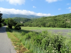
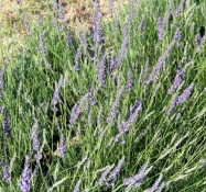
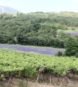
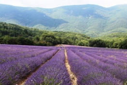
Die Gegend ist landwirtschaftlich wieder intensiver genutzt. Ackerbau und Obstplantagen überwiegen. Dazwischen einige Lavendelfelder. Die ersten, die wir sehen, sind schon abgeerntet. Zehn Kilometer geht es Auf und Ab auf der Nebenstraße voran. Dabei passieren wir auch mehrere blühende Lavendelfelder. Sehr schön vor dem Hintergrund der grünen Berge.
Informationen zu Urheber-Rechten | |
|---|---|
Rechte-Ausprägung / Lizenz | by-sa: CREATIVE COMMONS Namensnennung, Weitergabe unter gleichen Bedingungen |
Link zur Rechtebeschreibung | |
übernommen / bearbeitet am | 07.09.2018
|
übernommen / bearbeitet durch |
|
Informationen zu Urheber-Rechten | |
|---|---|
Rechte-Inhaber | |
Rechte-Ausprägung / Lizenz | © Alle Rechte vorbehalten. |
Bild hochgeladen | durch ThimbleU am 07.09.2018
|
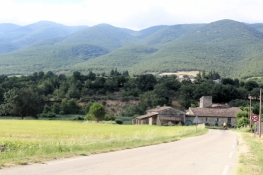
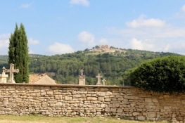
Dann gelangen wir wieder an die Hauptstraße des Tales, die D4100. Der Radweg biegt aber knapp davor scharf rechts ab und mündet in eine Nebenstraße, auf der es rund 100 Höhenmeter bergauf geht. Kurz hinter dem höchsten Punkt beginnen die Neubaugebiete von Céreste. Wir können es wieder rollen lassen. Im Ort kommen wir am Wochenmarkt vorbei. Danach geht es durch die Talsenke über eine kleine Brücke aus Römerzeiten wieder auf die Bahntrasse. Die lassen wir aber rechts liegen und kürzen über die asphaltierte Nebenstraße ein wenig ab. Bald geht es wieder ordentlich den Hang hinauf. Und wieder hinunter zur ehemaligen Prieuré de Carluc. Von dem Priorat ist im Wesentlichen nur noch das Kirchengebäude vorhanden. Die Anlage steht in einem einsamen Tal.
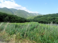
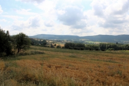
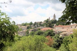
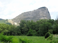
Weitere 100 Höhenmeter stehen an, um in den Ort Reillanne zu gelangen. Auf dem Hauptplatz ist Wochenmarkt und wir versorgen uns mit frischem Obst. Dann reizt es uns, bis zur Kapelle Saint-Denis auf der Spitze des Berges hinauf zu radeln. Von hier hat man einen tollen Ausblick über das Tal des Cavalon und die umliegenden Höhenzüge. Die Kapelle selbst ist verschlossen. Sie muss Teil einer wehrhaften Anlage rund um die Bergspitze gewesen sein.
Informationen zu Urheber-Rechten | |
|---|---|
Rechte-Ausprägung / Lizenz | by-sa: CREATIVE COMMONS Namensnennung, Weitergabe unter gleichen Bedingungen |
Link zur Rechtebeschreibung | |
übernommen / bearbeitet am | 07.09.2018
|
übernommen / bearbeitet durch |
|
Informationen zu Urheber-Rechten | |
|---|---|
Rechte-Inhaber | |
Rechte-Ausprägung / Lizenz | © Alle Rechte vorbehalten. |
Bild hochgeladen | durch ThimbleU am 07.09.2018
|
Hinter dem Ort nochmals bergauf und dann durch Wald ein einsames Tal lange hinunter bis zur D4100.
Für fünf Kilometer führt die Route des EV8 jetzt über die Hauptstraße, die Verkehrsbelastung ist aber geringer als erwartet. Ein kurzes Stück D5 und dann rollen wir ins Tal hinunter nach Biabaux. Dort kommen wir wieder auf die Bahntrasse, die wieder gut asphaltiert ist und uns bis hinter Dauphin führt. Hier wenden wir uns vom ausgeschilderten EV8 ab, radeln ein Stück durch den Ort Saint-Maime und biegen dann auf die D13. Auch hier ist der Verkehr nicht so stark wie erwartet, durch eine Baustelle bedingt fließt er aber in kleinen Konvois das Tal hinunter. Vor Volx treffen wir wieder auf den EV8, der von links kommt, und biegen hier rechts Richtung Volx auf die Nebenstraße ab. Es geht etwas hinauf in den Ort, dann auf Radwegen neben der Straße hinunter bis zum Kanal.
Informationen zu Urheber-Rechten | |
|---|---|
Rechte-Ausprägung / Lizenz | by-sa: CREATIVE COMMONS Namensnennung, Weitergabe unter gleichen Bedingungen |
Link zur Rechtebeschreibung | |
übernommen / bearbeitet am | 07.09.2018
|
übernommen / bearbeitet durch |
|
Informationen zu Urheber-Rechten | |
|---|---|
Rechte-Inhaber | |
Rechte-Ausprägung / Lizenz | © Alle Rechte vorbehalten. |
Bild hochgeladen | durch ThimbleU am 07.09.2018
|
Informationen zu Urheber-Rechten | |
|---|---|
Rechte-Inhaber | |
Rechte-Ausprägung / Lizenz | © Alle Rechte vorbehalten. |
Bild hochgeladen | durch ThimbleU am 07.09.2018
|
Für fast vier Kilometer geht es auf Straßen, die eher wie Baustraßen wirken, nahe dem Kanal nach Südwesten. Dann weiter auf Nebenstraßen bis zum Bahnhof von Manosque. Wir wollen die Abfahrtzeit der Züge morgen früh klären und uns vergewissern, dass die SNCF Mitarbeiter keinen Streiktag haben. Das ist schnell erledigt.
Jetzt bleibt noch eine Unterkunft zu suchen. Das Chambres d’Hôtes nahe dem Bahnhof gibt es nicht mehr. Das Hotel wenig weiter ist voll belegt. Die Dame in der Tourist-Information ist sehr zurückhaltend in der Klärung der Unterkunftsfrage. Also setzen wir uns wieder aufs Rad und fahren zu den zwei Hotels aus unserem Tourenbuch. Beim ersten kriegen wir sodann das letzte freie Zimmer des Hauses.
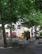
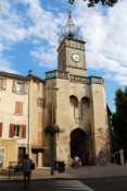
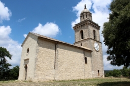
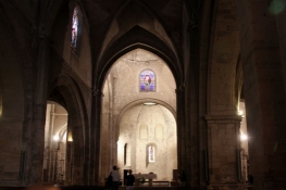
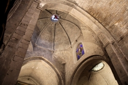
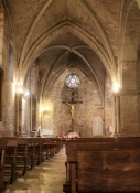
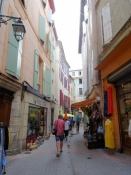
Der Stadtrundgang ist kurz. Es gibt zwei romanische Kirchen in der Altstadt. Beide beeindrucken durch die Schlichtheit der Ausstattung und der Perfektion der romanischen Bauweise. Ansonsten gibt es einige hübsche Gassen und Plätze.
Informationen zu Urheber-Rechten | |
|---|---|
Rechte-Ausprägung / Lizenz | by-sa: CREATIVE COMMONS Namensnennung, Weitergabe unter gleichen Bedingungen |
Link zur Rechtebeschreibung | |
übernommen / bearbeitet am | 07.09.2018
|
übernommen / bearbeitet durch |
|

Informationen zu Urheber-Rechten | |
|---|---|
Rechte-Inhaber | |
Rechte-Ausprägung / Lizenz | © Alle Rechte vorbehalten. |
Bild hochgeladen | durch ThimbleU am 07.09.2018
|