
Cycle Tour From Munich via Salzburg, Passau to Günzburg
Travel report: Oberbayern, Salzach, Inn und Donau
Actions
![]()
Please wait - map data are loading
Added on 04 Nov 2011,
last edited by ThimbleU on 12 Jul 2016
Actions
Cycle route metrics
planned
ridden
Total distance in km
700
727
Cumulative elevation gain in m
7.450
5.704
Avg. slope uphill in %
1,06
0,78
Cumulative elevation loss in m
7.508
5.593
Total cycling hours
-
43,3
Avg. pace in km/h
-
16,8
Information about rights to the gps-track data | |
|---|---|
Rights owner | |
Rights characteristic / license | by-nc-sa: CREATIVE COMMONS Attribution-NonCommercial-ShareAlike |
Link to the description of the license | |
GPX file uploaded | by ThimbleU on 04 Nov 2011
|
Track points in total
7.280
11.175
Track points per km (avg)
10
15
Start/endpoint
Start location
München, Bayern, DE (529 m NHN)
End location
Günzburg, Bayern, DE (471 m NHN)
Stages
Information about copyright | |
|---|---|
Rights owner | |
Rights characteristic / license | © all rights reserved. |
Image has been uploaded | by biroto-Redaktion on 04 Nov 2011
|
70 km
München - Wasserburg
Information about copyright | |
|---|---|
Rights owner | |
Rights characteristic / license | © all rights reserved. |
Image has been uploaded | by biroto-Redaktion on 04 Nov 2011
|
78 km
Wasserburg - Traunsein - Inzell
Information about copyright | |
|---|---|
Rights owner | |
Rights characteristic / license | © all rights reserved. |
Image has been uploaded | by biroto-Redaktion on 04 Nov 2011
|
42 km
Inzell - Salzburg
Information about copyright | |
|---|---|
Rights owner | |
Rights characteristic / license | © all rights reserved. |
Image has been uploaded | by biroto-Redaktion on 04 Nov 2011
|
128 km
Salzburg - Tittmoning - Burghausen - Egglfing am Inn
Information about copyright | |
|---|---|
Rights owner | |
Rights characteristic / license | © all rights reserved. |
Image has been uploaded | by biroto-Redaktion on 04 Nov 2011
|
96 km
Egglfing am Inn - Passau - Deggendorf
Information about copyright | |
|---|---|
Rights owner | |
Rights characteristic / license | © all rights reserved. |
Image has been uploaded | by biroto-Redaktion on 04 Nov 2011
|
94 km
Deggendorf - Regensburg
Information about copyright | |
|---|---|
Rights owner | |
Rights characteristic / license | © all rights reserved. |
Image has been uploaded | by biroto-Redaktion on 04 Nov 2011
|
116 km
Regensburg - Neuburg a.d.Donau
Information about copyright | |
|---|---|
Rights owner | |
Rights characteristic / license | © all rights reserved. |
Image has been uploaded | by biroto-Redaktion on 04 Nov 2011
|
102 km
Neuburg a.d.Donau - Günzburg
Beds4Cyclists, worth visiting and infrastructure
Name and address
Latitude / Longitude
Phone
Fax
Mobile
Type of accommodation
Rating for cyclists
Route km
Dist. to route
Elevation
0 km
2,8 km
543 m
0 km
4,5 km
514 m
Information about copyright | |
|---|---|
Rights owner | |
Rights characteristic / license | by-sa: CREATIVE COMMONS Attribution-ShareAlike |
Link to the description of the license | |
Image taken over from | commons.wikimedia.org/wiki/File:Schloss_Nymphenburg_Munich.jpg |
Image has been uploaded | by biroto-Redaktion on 09 Jan 2013
|
Information about copyright | |
|---|---|
Rights owner | |
Rights characteristic / license | by-sa: CREATIVE COMMONS Attribution-ShareAlike |
Link to the description of the license | |
Image taken over from | commons.wikimedia.org/wiki/File:Exterior_del_Palacio_de_Nymphenburg,_Múnich,_Alemania61.JPG |
Image has been uploaded | by biroto-Redaktion on 09 Jan 2013
|
Information about copyright | |
|---|---|
Rights owner | |
Rights characteristic / license | by-sa: CREATIVE COMMONS Attribution-ShareAlike |
Link to the description of the license | |
Image taken over from | |
Image has been uploaded | by biroto-Redaktion on 09 Jan 2013
|
Information about copyright | |
|---|---|
Rights owner | |
Rights characteristic / license | by-sa: CREATIVE COMMONS Attribution-ShareAlike |
Link to the description of the license | |
Image taken over from | commons.wikimedia.org/wiki/File:Schlosspark_nymphenburg1.jpg |
Image has been uploaded | by biroto-Redaktion on 09 Jan 2013
|
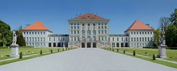
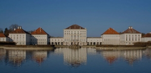
Schloss Nymphenburg liegt im Westen Münchens ![]() im Stadtbezirk Neuhausen-Nymphenburg
im Stadtbezirk Neuhausen-Nymphenburg ![]() . Es bildet zusammen mit dem Schlosspark Nymphenburg
. Es bildet zusammen mit dem Schlosspark Nymphenburg ![]() und den kleinen Parkburgen eine Einheit. Es zählt zu den großen Königsschlössern Europas und ist heute eine vielbesuchte Sehenswürdigkeit. Das Schloss war lange Zeit die Sommerresidenz der Wittelsbacher
und den kleinen Parkburgen eine Einheit. Es zählt zu den großen Königsschlössern Europas und ist heute eine vielbesuchte Sehenswürdigkeit. Das Schloss war lange Zeit die Sommerresidenz der Wittelsbacher ![]() .
.
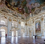
Museen
Das Schloss beherbergt einige Museen:
- Marstallmuseum
 (Südflügel)
 - Porzellanmuseum München (Südflügel)
- Museum Mensch und Natur (Nordflügel)
- Erwin von Kreibig-Museum (Südliches Schlossrondell)
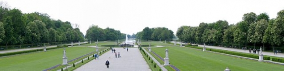
Schlosspark
→ Hauptartikel: Schlosspark Nymphenburg ![]()
Mit dem Schloss entstand zunächst ein kleiner Garten im italienischen Stil. In den Jahren von 1701 bis 1704 wurden Veränderungen und Erweiterungen des Gartens im Stil des französischen Barocks. Die Schaffung eines weitläufigen Landschaftsparks nach englischem Vorbild begann 1804 mit dem südlichen Parkteil, der 1807 fertiggestellt war und wurde 1810 bis 1823 mit dem nördlichen Teil vollendet.
Der Mittelkanal mit der Großen Kaskade teilt den Landschaftspark des Nymphenburger Parks in einen nördlichen und einen südlichen Bereich. Die Wasserzufuhr erfolgt von Westen aus der Würm ![]() über den Pasing-Nymphenburger Kanal
über den Pasing-Nymphenburger Kanal ![]() , der zum Nordmünchner Kanalsystem
, der zum Nordmünchner Kanalsystem ![]() gehört. Das Wasser wird über zwei Kanäle nach Osten und Nordosten, sowie über den Hartmannshofer Bach nach Norden abgeleitet.
gehört. Das Wasser wird über zwei Kanäle nach Osten und Nordosten, sowie über den Hartmannshofer Bach nach Norden abgeleitet.
Im nördlichen Teil befindet sich der kleinere Pagodenburger See mit der Pagodenburg. Der botanische Garten ![]() im Nordosten ist nicht Bestandteil des Nymphenburger Parks; er ist teilweise durch eine Mauer und eine Straße vom Park getrennt.
im Nordosten ist nicht Bestandteil des Nymphenburger Parks; er ist teilweise durch eine Mauer und eine Straße vom Park getrennt.
Im südlichen Teil befinden sich der größere Badenburger See mit Apollotempel und der Badenburg. Das Grüne Brunnhaus mit der Wassermühle für die Druckpumpen der Gartenfontäne im Dörfchen steht am südlichen, das Niveau des Würmkanals behaltenden Kanals. Die Amalienburg bestimmt den südöstlichen Parkteil.
Information about copyright | |
|---|---|
Rights characteristic / license | by-sa: CREATIVE COMMONS Attribution-ShareAlike |
Link to the description of the license | |
Input taken over from: |
Seite „Schloss Nymphenburg“. In: Wikipedia, Die freie Enzyklopädie. Bearbeitungsstand: 3. Dezember 2012, 00:59 UTC. URL: http://de.wikipedia.org/w/index.php?title=Schloss_Nymphenburg&oldid=111224071 (Abgerufen: 9. Januar 2013, 15:58 UTC) |
taken over / edited on | 09 Jan 2013 - 26 Feb 2013
|
taken over / edited by |
|
Hours of opening
Schloss Nymphenburg, Marstallmuseum mit Museum "Nymphenburger Porzellan"
April bis 15. Oktober: 9-18 Uhr
16. Oktober bis März: 10-16 Uhr
täglich geöffnet
Amalienburg, Badenburg, Pagodenburg und Magdalenenklause
April bis 15. Oktober: 9-18 Uhr (täglich geöffnet)
16. Oktober bis März: geschlossen
Letzter Einlass ist in allen Objekten 20 Minuten vor Ende der angegeben Öffnungszeit.
Alle Objekte sind an folgenden Tagen geschlossen: 1. Januar, Faschingsdienstag, 24, 25. und 31. Dezember
Schlosspark
Januar, Februar und November: 6.30-18 Uhr
März: 6-18.30 Uhr
April und September: 6-20.30 Uhr
Mai-August: 6-21.30 Uhr
Oktober: 6-19 Uhr
Dezember: 6.30-17.30 Uhr
Die Fontänen sind in der Regel von Ostern bis Mitte Oktober täglich von10 bis 12 Uhrund von14 bis 16 Uhr in Betrieb.
0 km
2,0 km
524 m
0 km
0,6 km
530 m
0 km
3,6 km
509 m
Information about copyright | |
|---|---|
Rights owner | Lukáš Hron |
Rights characteristic / license | by-sa: CREATIVE COMMONS Attribution-ShareAlike |
Link to the description of the license | |
Image taken over from | |
Image has been uploaded | by Ottocolor on 20 Mar 2013
|
Information about copyright | |
|---|---|
Rights owner | Philipp Junger |
Rights characteristic / license | by-sa: CREATIVE COMMONS Attribution-ShareAlike |
Link to the description of the license | |
Image taken over from | |
Image has been uploaded | by Ottocolor on 20 Mar 2013
|
Information about copyright | |
|---|---|
Rights owner | Jorge Royan |
Rights characteristic / license | by-sa: CREATIVE COMMONS Attribution-ShareAlike |
Link to the description of the license | |
Image taken over from | commons.wikimedia.org/wiki/File:Munich_-_Frei_Otto_Tensed_structures_-_5406.jpg |
Image has been uploaded | by Ottocolor on 20 Mar 2013
|
Information about copyright | |
|---|---|
Rights owner | Henning Schlottmann |
Rights characteristic / license | by-sa: CREATIVE COMMONS Attribution-ShareAlike |
Link to the description of the license | |
Image taken over from | commons.wikimedia.org/wiki/File:Olympic_parc_Munich_0617.JPG |
Image has been uploaded | by Ottocolor on 20 Mar 2013
|
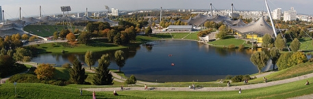
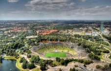
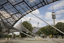
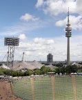
The Olympiapark in Munich ![]() , Germany, is an Olympic Park
, Germany, is an Olympic Park ![]() which was constructed for the 1972 Summer Olympics
which was constructed for the 1972 Summer Olympics ![]() . Found in the area of Munich known as the "Oberwiesenfeld" ("upper meadow-field"), the Park continues to serve as a venue for cultural, social, and religious events such as events of worship. The Park is administered by Olympiapark München GmbH, a holding company fully owned by the state capital of Munich.
. Found in the area of Munich known as the "Oberwiesenfeld" ("upper meadow-field"), the Park continues to serve as a venue for cultural, social, and religious events such as events of worship. The Park is administered by Olympiapark München GmbH, a holding company fully owned by the state capital of Munich.
The use of the term Olympiapark to designate the overall area has prevailed as a semiofficial practice, but no official name for the entire area exists: Rather, the general area comprises four separate sub-areas:
- Olympic Area: Includes the Olympic sports facilities such as the Olympic Stadium and the Olympic Hall with Olympic Tower . Also in this area are the Olympic Swim Hall and Olympic Event Hall.
- Olympic Village , comprising two villages, one male and one female.
- Olympic Media City ("Pressestadt"), today the home of the Olympic Shopping Center. Strictly speaking, this portion belongs to the area of district of "Moosach."
- Olympic Park: Adjoining the Olympic Area to the south, this park includes the Olympic Mountain and Olympic Lake.
Information about copyright | |
|---|---|
Rights characteristic / license | by-sa: CREATIVE COMMONS Attribution-ShareAlike |
Link to the description of the license | |
Input taken over from: |
Olympiapark, Munich. (2013, March 19). In Wikipedia, The Free Encyclopedia. Retrieved 15:29, March 20, 2013, from http://en.wikipedia.org/w/index.php?title=Olympiapark,_Munich&oldid=545339022 |
taken over / edited on | 20 Mar 2013
|
taken over / edited by |
|
![]()