
Cycle Tour Fulda nach Lourdes
Tag 17: Le Puy - Les Faux
![]()
Please wait - map data are loading
Added on 22 Dec 2013
last edited by Tandemteam-Traudel_und_Dieter on 03 Jan 2015
Cycle route metrics
ridden
Total distance in km
72
Cumulative elevation gain in m
2.499
Avg. slope uphill in %
3,47
Cumulative elevation loss in m
2.018
Total cycling hours
6,7
Avg. pace in km/h
10,7
Min. height
595
Max. height
1.312
Information about rights to the gps-track data | |
|---|---|
Rights owner | |
Rights characteristic / license | by-sa: CREATIVE COMMONS Attribution-ShareAlike |
Link to the description of the license | |
GPX file uploaded | by Tandemteam-Traudel_und_Dieter on 30 Dec 2013
|
Track points in total
551
Track points per km (avg)
8
Start/endpoint
Start location
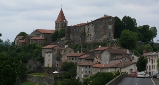
Le Puy-en-Velay, Auvergne-Rhône-Alpes, FR (644 m NHN)
End location
Saint-Alban-sur-Limagnole, Occitania, FR (1125 m NHN)
ridden on
17 Jun 2007
Weather
Bedeckt, stellenweise Sturm
Properties
Nebenstraßen (durch Baustelle D589)
Travel report
Information about copyright | |
|---|---|
Rights owner | |
Rights characteristic / license | © all rights reserved. |
Image has been uploaded | by Tandemteam-Traudel_und_Dieter on 03 Jan 2015
|
Information about copyright | |
|---|---|
Rights owner | |
Rights characteristic / license | © all rights reserved. |
Image has been uploaded | by Tandemteam-Traudel_und_Dieter on 03 Jan 2015
|
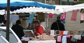
Heute Morgen erst um 7:00 Uhr in den Dom zur Pilgermesse. Ca 8:15 Uhr wieder zurück in der Jugendherberge zum Frühstück. Es waren noch drei Gäste da, die hatten das Frühstück schon fast alleine gegessen, zu unserer Überraschung. Es gab noch je eine Tasse Kaffee und ein Stück Brot. Dafür ist die heutige Etappe sehr anstrengend, es geht lange fast nur bergauf. Mit dem Wetter hatten wir wieder Glück, das Gewitter kam nachdem wir eine Unterkunft gefunden haben.
Information about copyright | |
|---|---|
Rights characteristic / license | by-sa: CREATIVE COMMONS Attribution-ShareAlike |
Link to the description of the license | |
taken over / edited on | 09 Dec 2014
|
taken over / edited by |
|
Information about copyright | |
|---|---|
Rights owner | |
Rights characteristic / license | © all rights reserved. |
Image has been uploaded | by Tandemteam-Traudel_und_Dieter on 03 Jan 2015
|
Information about copyright | |
|---|---|
Rights owner | |
Rights characteristic / license | © all rights reserved. |
Image has been uploaded | by Tandemteam-Traudel_und_Dieter on 03 Jan 2015
|
Information about copyright | |
|---|---|
Rights owner | |
Rights characteristic / license | © all rights reserved. |
Image has been uploaded | by Tandemteam-Traudel_und_Dieter on 03 Jan 2015
|