
Radtour Eiserner Vorhang Tour, Teil 2, Klaipeda-Gdingen
Reisebericht: From Lithuania via Kaliningrad (Russia) to Poland
Aktionen
![]()
Bitte warten - Kartendaten werden geladen
Erstellt am 22.01.2019,
zuletzt geändert von Ottocolor am 28.02.2020
Aktionen
Strecken-Merkmale
geplant
gefahren
Gesamtlänge in km
337
311
Gesamthöhenmeter Aufstieg
2.197
1.708
Durchschn. Steigung Aufstieg %
0,65
0,55
Gesamthöhenmeter Abstieg
2.192
1.714
Informationen zu Rechten an den GPS-Track-Daten | |
|---|---|
Rechte-Inhaber | |
Rechte-Ausprägung / Lizenz | cc0: Public Domain keine Rechte vorbehalten |
Link zur Rechtebeschreibung | |
gpx-Datei hochgeladen | durch Ottocolor am 07.03.2019
|
Gesamtzahl Trackpoints
3.879
4.470
Trackpoint-Dichte per km
9
14
Endorte
Start
Klaipėda, Klaipeda County, LT (1 m NHN)
Ziel
Gdynia, Pomeranian Voivodeship, PL (6 m NHN)
Charakter
Informationen zu Urheber-Rechten | |
|---|---|
Rechte-Ausprägung / Lizenz | by-sa: CREATIVE COMMONS Namensnennung, Weitergabe unter gleichen Bedingungen |
Link zur Rechtebeschreibung | |
übernommen / bearbeitet am | 22.01.2019 - 07.03.2019
|
übernommen / bearbeitet durch |
|
Landschaft
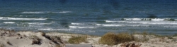
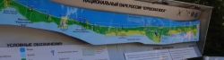
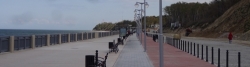
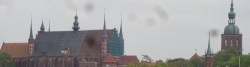
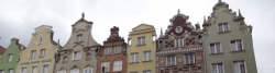
My cycling holiday in May 2019 leads me and my bike through coastal scenery along the easternmost Baltic Sea from Lithuania via Russia to Poland. A specialty over here are long sandy spits (the Curonian spit is almost 100 km long), which lie outside the old coastline and thus form large fjords. The second spit is called the Vistula Spit. And they are both divided in the middle between two countries, respectively. Lithuania / Russia and Russia / Poland. The Russian part of the Vistula spit is blocked for the public. mainly due to a military area around the city of Baltiysk. The Curonian spit I intend to ride in its full length, while I set over to the Vistula spit and cycle approx. 20 km of its length. They are both very sandy with very high dunes, large dune plantations to keep on the sand and a fine sandy beach as far as the eye can see. The starting point of my tour is a crossing of the Baltic Sea from Karlshamn in Sweden to the old German Hanseatic city of Memel, which has been called Klaipeda for 101 years now, because it is in Lithuania. But the German empire spread this far. Funnily the German border village north of Memel was called Nimmersatt. That means "never satisfied". One may think that when you're never satisfied, you eventually lose everything again. What the Germans then did in two stages after two lost world wars they had started themselves, so today the eastern border of Germany runs over a thousand kilometers further west near Swinoujscie. Another fact is that the Russian Kaliningrad region, which I cycle into on the second stage, once again is an exclave, ie. it is not connected to the Russian motherland to the east, just as it was in Germany between the world wars. At that time it was called the East Prussia and Kaliningrad was named Königsberg. It means the King's hillI, and that's because it was the Prussian kings' crown town and residence town along with Berlin. Russia is the core of my cycling holiday, although I only stay here for three days. Not much when you consider that the visa to Russia cost me around 1250 Danish kr. The first stage is thus in Lithuania. Here, the spit fs a national park with a first-class bike path and lovely little towns on the fjord side. My goal of stage 1 is the largest town, which is not big, Nida. Here The world famous German writer Thomas Mann ("Die Buddenbrooks") owned a cottage, which today is a museum for his memory. The first Russian stage goes from the border town of Nida (in the middle of the spit) to Svetlogorsk on the north coast of the Sambian peninsula. Like Zelenogradsk (Cranz) further east, it was a German seaside resort and was called Rauschen. There is still some old German seaside architecture left behind, of course rebuilt after the devastation of war and the neglect of Soviet times. Here the coast is quite high and steep. There is even a cable car from the railway station in Svetlogorsk down to the beach, which is quite narrow here, but still sandy. On the third day, I cycle on to the destination city of Kaliningrad, hopefully via the town of Yantarnyj in western Sambia. "Yantar" means "amber" in Russian, and it is not false advertising, because the city has a giant big open mine and produces about a third of the world's raw amber. The exploitation of the amber deposits has a long tradition, of course also in German time and has contributed to the wealth of Königsberg / Kaliningrad. Then I cycle over the hilly Sambian peninsula, which lies between the two fjords behind the two long spits. It is going to be a bit special to cycle into Kaliningrad, just under half a million inhabitants. The Russians are not used to bicycles outside the cities, so care must be taken. Inside the cities, however, a lot of cycling goes on, so here one's right to existence can be claimed, but of course traffic is entirely on the premises of the cars. So it will be nice to cycle through a few parks, including the Victory park (Park Pobedy) in honour of the Soviet Union's victory in World War II. And coincidentally the day after it ieally is Victory day (Dyen Pobedy), May 9, which is a great day of celebration in Russia. Probably a parade is staged in this victory park and in the city as such. This day is even a day of rest, because I have booked two nights at the very centrally located hotel "Skipper". Its name proves the city's proudness of the its maritime flair and the district in which it is located, they call the "Fishermen's Village" (Rybnaja derevnja). Here are a few old houses are resurrected in old style and give the city a bit of historical flair. Which it completely lost during and after the war, which turned out a pure disaster for the city's German population. The German "Gauleiter" Erich Koch had closed the city and declared it a fortress. This resulted in thousands and thousands of innocent victims when Soviet artillery and tanks broke into the ancient and beautiful Hanseatic city. The following year, the remains of Königsberg were named after the then Soviet Union president Mikhail Kalinin, one of Stalin's loyal men. A few years ago, there was an indicative referendum in town about whether it should have its old name back (like Leningrad / St. Petersburg), but the proposal fell by a small majority. After the end of the war, the new Russian rulers were hard at the city and its German inhabitants. The survivors were all expelled, and not many houses were rebuilt in original style or allowed to remain. An exception is the cathedral (Kafedralnyi sobor), which houses the tomb of philosopher Immanuel Kant. It is located on the island of Kneiphof (now called Kant Island) between two arms of the river Pregolya. The royal palace, which was no more damaged than it could have been repaired, was demolished, and a giant colossus of a concrete block, the House of Soviets, was erected instead. In my eyes one of the world's largest eyesores. In recent times, an archaeological excavation has been made on the site, which has exposed some of the cellars of the castle. Along with the cathedral, a couple of the city's gates are also preserved. One of them houses the amber museum. An obvious opportunity for a visit. And I guess I'll have at ride to the new football stadium, where last year I saw a match during the football World Cup with my sons. Maybe there is a party going on out there on the "Victory Day"? The end of the cycling holiday is devoted to Poland. To get along quickly, I grab the suburban train to the border town of Mamonovo, which was called Heiligenbeil in German time. Here I cross the border back to the EU. Shortly after, I reach Frombork at the Wisla Fjord. This city was probably worth looking into as it was Nikolaus Kopernikus' hometown, and his observatory is preserved. But, at best, I only catch a glimpse of it all before I take the ferry Monika to Krynica Morska on the Vistula spit. Here I hope for anything but strong west wind, because I want to go all the way to Sobieszewska Island close to the city of Gdańsk. Along the way, I cross the canal of the Vistula mouth by a ferry that does not run in strong winds. Originally, the Vistula River (in German Weichsel, in Polish Wisla) flows into the Baltic Sea iby way of a very large river delta. Today, most of the arms are "dead" (one is even called "Dead Vistula" (Martwa Wisla) or fed by other rivers. There is a small history of the Vistula fjord and spit. As the fjord's exit lies in Russia (at Baltiiysk), the Poles have plans to dig a canal trough through the spit to have an exit for ships to the Baltic Sea, but environmental concerns have so far postponed the plans. At the end of the day I have hopefully pitched my tent at the "Eagle's Nest" campsite on the Sobieszewska island inside the city borders. Together with Nida on the first stage it is the only two nights I sleep in my tent. The island is a nature reserve and some of a bird's paradise. But I won't have an eye for that as I "haste towards another old German Hanseatic city in Slavonic hands, namely Gdańsk / Danzig. It is only slightly smaller than Kaliningrad, but is much more well preserved. Thank goodness it was not nearly as devastated 74 years ago. It is said to be a very beautiful city with a very large cathedral in the Baltic Sea gothic style, which is seen all the way from Riga to Lübeck. In addition to it, the old river port with the wooden crane and "The Long Square", which is surrounded by beautiful old citizen houses with the gable facing the square, is worth seeing. In fact much more is, and I know that I will miss more time here, but I need to ride some 30 km more to Poland's largest port town of Gdynia, from where I'll take the Stena ferry back across the Baltic to Sweden. On the way there, I cycle through the seaside resort of Sopot, and I have thus been in all three cities that are gathered in the city region "Three city" (Trojmiasto). Gdynia is called Gdingen in German. It was too strange for the Nazis who called it Gotenhafen. Here one of the worst tragedies of the Second World War unfolded, when in January 1945, the refugee ship of Wilhelm Gustloff departed from here with desperate German refugees fleeing from the Soviet army. A few miles out on the icy Baltic Sea it was torpedoed by a Soviet submarine and sank. An unknown number of people, including many children, drowned, perhaps as many as 10,000. The submarine commander was called Marinesco. He is a hero in Russia even today, and in many cities, also in Kaliningrad, there are places and streets named after him. War is truly a relentless and inhuman size. Fortunately, I do not have to fear such a mischievous fate, but can rest my head on a soft pillow and sleep safely before I wake up outside Karlskrona. The cycling holiday "Iron Curtain Trip, Part 2" is over. Read more and see pictures when I have uploaded ithem during summer.
Informationen zu Urheber-Rechten | |
|---|---|
Rechte-Ausprägung / Lizenz | by-sa: CREATIVE COMMONS Namensnennung, Weitergabe unter gleichen Bedingungen |
Link zur Rechtebeschreibung | |
übernommen / bearbeitet am | 18.05.2019
|
übernommen / bearbeitet durch |
|
An- und Abreise
OUTBOUND: Train Odense-Karlshamn, ferry Karlshamn-Klaipeda.
HOMEBOUND: Ferry Gdynia-Karlskrona, train Karlskrona-Odense.
Etappen
Informationen zu Urheber-Rechten | |
|---|---|
Rechte-Inhaber | |
Rechte-Ausprägung / Lizenz | by-sa: CREATIVE COMMONS Namensnennung, Weitergabe unter gleichen Bedingungen |
Link zur Rechtebeschreibung | |
Bild hochgeladen | durch Ottocolor am 18.05.2019
|
69 km
Klaipeda-Nida
Informationen zu Urheber-Rechten | |
|---|---|
Rechte-Inhaber | |
Rechte-Ausprägung / Lizenz | by-sa: CREATIVE COMMONS Namensnennung, Weitergabe unter gleichen Bedingungen |
Link zur Rechtebeschreibung | |
Bild hochgeladen | durch Ottocolor am 18.05.2019
|
64 km
Nida-Svetlogorsk
Informationen zu Urheber-Rechten | |
|---|---|
Rechte-Inhaber | |
Rechte-Ausprägung / Lizenz | by-sa: CREATIVE COMMONS Namensnennung, Weitergabe unter gleichen Bedingungen |
Link zur Rechtebeschreibung | |
Bild hochgeladen | durch Ottocolor am 19.05.2019
|
59 km
Svetlogorsk-Kaliningrad
Informationen zu Urheber-Rechten | |
|---|---|
Rechte-Inhaber | |
Rechte-Ausprägung / Lizenz | by-sa: CREATIVE COMMONS Namensnennung, Weitergabe unter gleichen Bedingungen |
Link zur Rechtebeschreibung | |
Bild hochgeladen | durch Ottocolor am 19.05.2019
|
Hviledag/rest day Kaliningrad
Informationen zu Urheber-Rechten | |
|---|---|
Rechte-Inhaber | |
Rechte-Ausprägung / Lizenz | by-sa: CREATIVE COMMONS Namensnennung, Weitergabe unter gleichen Bedingungen |
Link zur Rechtebeschreibung | |
Bild hochgeladen | durch Ottocolor am 19.05.2019
|
66 km
Kaliningrad-Wyspa Sobieszewska
Informationen zu Urheber-Rechten | |
|---|---|
Rechte-Inhaber | |
Rechte-Ausprägung / Lizenz | by-sa: CREATIVE COMMONS Namensnennung, Weitergabe unter gleichen Bedingungen |
Link zur Rechtebeschreibung | |
Bild hochgeladen | durch Ottocolor am 19.05.2019
|
53 km
Wyspa Sobieszewska-Gdynia
Fahrradfreundliche Unterkünfte, Sehenswertes und Infrastruktur
Name u. Anschrift
Breite / Länge
Tel.
Fax.
Mobile
Art d. Unterkunft
Radler-freund-lichkeit
Strecken-km
km zur Strecke
Höhe
2 km
0,1 km
5 m
5 km
0,2 km
9 m
5 km
0,2 km
5 m
6 km
0,0 km
10 m
Öffnungszeiten
Oktober – April: Montag – Freitag 9.00-18.00 Uhr
Mai: Montag – Freitag 9.00-18.00 Uhr, Samstag 10.00-16.00 Uhr
Juni – August: Montag – Freitag 9.00-19.00 Uhr, Samstag – Sonntag 10.00-16.00 Uhr
September: Montag – Freitag 9.00-18.00 Uhr, Samstag 10.00-16.00 Uhr
Sprachen:
lietuvių kalba
6 km
0,0 km
9 m
Informationen zu Urheber-Rechten | |
|---|---|
Rechte-Inhaber | |
Rechte-Ausprägung / Lizenz | by-sa: CREATIVE COMMONS Namensnennung, Weitergabe unter gleichen Bedingungen |
Link zur Rechtebeschreibung | |
Bild übernommen aus | commons.wikimedia.org/wiki/File:Klaipeda-Stadtrundgang_02.jpg |
Bild hochgeladen | durch biroto-Redaktion am 04.11.2011
|
Informationen zu Urheber-Rechten | |
|---|---|
Rechte-Inhaber | |
Rechte-Ausprägung / Lizenz | by-sa: CREATIVE COMMONS Namensnennung, Weitergabe unter gleichen Bedingungen |
Link zur Rechtebeschreibung | |
Bild übernommen aus | commons.wikimedia.org/wiki/File:Klaipeda_-_Annchen_von_Tharau_with_Folklore_Group.jpg |
Bild hochgeladen | durch biroto-Redaktion am 04.11.2011
|
Informationen zu Urheber-Rechten | |
|---|---|
Rechte-Inhaber | |
Rechte-Ausprägung / Lizenz | by: CREATIVE COMMONS Namensnennung |
Link zur Rechtebeschreibung | |
Bild übernommen aus | commons.wikimedia.org/wiki/File:Klaipeda_Theaterplatz_Ost.jpg |
Bild hochgeladen | durch biroto-Redaktion am 04.11.2011
|
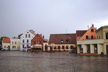
Alt- und Neustadt
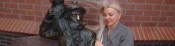
In der Altstadt von Klaipėda/Memel sind zahlreiche restaurierte Fachwerkhäuser aus dem 17. bis 19. Jahrhundert erhalten. Das Wahrzeichen der Stadt ist der ⊙ Simon-Dach-Brunnen mit einer Figur des aus einem Volkslied bekannten Ännchen von Tharau ![]() auf dem Theaterplatz in der Altstadt. Hierbei handelt es sich um eine Nachbildung, da das Original direkt nach dem Zweiten Weltkrieg abhanden gekommen war.
auf dem Theaterplatz in der Altstadt. Hierbei handelt es sich um eine Nachbildung, da das Original direkt nach dem Zweiten Weltkrieg abhanden gekommen war.
Jenseits des Flusses Danė liegt die im 18. und 19. Jahrhundert angelegte Neustadt, welche sich nach dem Zweiten Weltkrieg zum Geschäftszentrum der Stadt entwickelt hat.
In Klaipėda/Memel befinden sich außerdem zwei historische Postämter, davon das eine in einem kleinen Altstadthaus, das andere im Jugendstil mit einem bekannten Glockenspiel befindet sich in der Neustadt. Auf dem Fluss Danė liegt das ehemalige Segelschulschiff Meridianas (heute Restaurant).
Museem
Informationen zu Urheber-Rechten | |
|---|---|
Rechte-Ausprägung / Lizenz | by-sa: CREATIVE COMMONS Namensnennung, Weitergabe unter gleichen Bedingungen |
Link zur Rechtebeschreibung | |
Text(e) übernommen von: |
Seite „Klaipėda“. In: Wikipedia, Die freie Enzyklopädie. Bearbeitungsstand: 21. Februar 2012, 10:28 UTC. URL: http://de.wikipedia.org/w/index.php?title=Klaip%C4%97da&oldid=99940145 (Abgerufen: 8. März 2012, 15:00 UTC) |
übernommen / bearbeitet am | 08.03.2012 - 25.08.2016
|
übernommen / bearbeitet durch |
|
![]()