
Cycle Tour Kreuz und Quer durch die Schweiz
Tag 3: Sempach nach Flüelen
![]()
Please wait - map data are loading
Added on 08 Jan 2015
last edited by Tandemteam-Traudel_und_Dieter on 06 Feb 2015
Cycle route metrics
ridden
Total distance in km
73
Cumulative elevation gain in m
1.852
Avg. slope uphill in %
2,54
Cumulative elevation loss in m
1.914
Total cycling hours
4,1
Avg. pace in km/h
17,8
Min. height
422
Max. height
583
Information about rights to the gps-track data | |
|---|---|
Rights owner | |
Rights characteristic / license | by-sa: CREATIVE COMMONS Attribution-ShareAlike |
Link to the description of the license | |
GPX file uploaded | by Tandemteam-Traudel_und_Dieter on 12 Jan 2015
|
Track points in total
477
Track points per km (avg)
7
Start/endpoint
Start location
Sempach, Luzern, CH (504 m NHN)
End location
Flüelen, Uri, CH (442 m NHN)
ridden on
28 Jul 2008
Weather
bewölkt, in Flüelen Regen
Properties
überwiegend Teerstraßen
Travel report
Information about copyright | |
|---|---|
Rights owner | |
Rights characteristic / license | © all rights reserved. |
Image has been uploaded | by Tandemteam-Traudel_und_Dieter on 03 Feb 2015
|
Information about copyright | |
|---|---|
Rights owner | |
Rights characteristic / license | © all rights reserved. |
Image has been uploaded | by Tandemteam-Traudel_und_Dieter on 03 Feb 2015
|
Information about copyright | |
|---|---|
Rights owner | |
Rights characteristic / license | © all rights reserved. |
Image has been uploaded | by Tandemteam-Traudel_und_Dieter on 03 Feb 2015
|
Information about copyright | |
|---|---|
Rights owner | |
Rights characteristic / license | © all rights reserved. |
Image has been uploaded | by Tandemteam-Traudel_und_Dieter on 03 Feb 2015
|
Information about copyright | |
|---|---|
Rights owner | |
Rights characteristic / license | © all rights reserved. |
Image has been uploaded | by Tandemteam-Traudel_und_Dieter on 03 Feb 2015
|
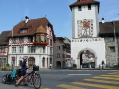
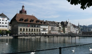
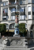
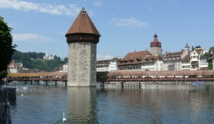
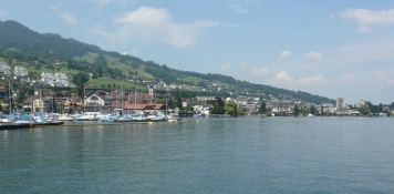
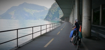
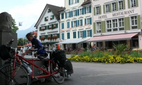
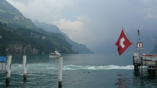
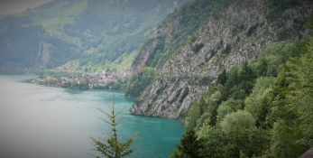
Heute weiter nach Luzern an den Vierwaldstätter See. Nach einem Stadtrundgang ging es am See weiter über Stans nach Beckenried. Von Beckenried mit der Fähre nach Gersau und am See weiter nach Brunnen zur Kaffeepause. Bei leichtem Regen ging es auf die in Fels gehauenen Axenstrasse am See entlang nach Flüelen. Auf dem Campingplatz angekommen hat es stärker geregnet. So bauten wir unser Zelt im Regen auf, und gingen nach Flüelen essen. Es regnete die Nacht durch bis nach dem Frühstück.
Information about copyright | |
|---|---|
Rights characteristic / license | by-sa: CREATIVE COMMONS Attribution-ShareAlike |
Link to the description of the license | |
taken over / edited on | 12 Jan 2015 - 05 Feb 2015
|
taken over / edited by |
|
Information about copyright | |
|---|---|
Rights owner | |
Rights characteristic / license | © all rights reserved. |
Image has been uploaded | by Tandemteam-Traudel_und_Dieter on 03 Feb 2015
|
Information about copyright | |
|---|---|
Rights owner | |
Rights characteristic / license | © all rights reserved. |
Image has been uploaded | by Tandemteam-Traudel_und_Dieter on 03 Feb 2015
|
Information about copyright | |
|---|---|
Rights owner | |
Rights characteristic / license | © all rights reserved. |
Image has been uploaded | by Tandemteam-Traudel_und_Dieter on 03 Feb 2015
|
Information about copyright | |
|---|---|
Rights owner | |
Rights characteristic / license | © all rights reserved. |
Image has been uploaded | by Tandemteam-Traudel_und_Dieter on 03 Feb 2015
|