Print the page content is only available to registered and logged in users and only as a tourbook!

Cycle Tour Northern Italy round trip part 1

Tag 6: Rovereto - Lazise

busy


Please wait - map data are loading

50150250350
Elevation profile Cycle Tour Northern Italy round trip part 150150250350020406080100120

Added on 10 May 2022

last edited by ThimbleU on 10 Sep 2022

Cycle route metrics

ridden

Total distance in km

75

Cumulative elevation gain in m

552

Avg. slope uphill in %

0,74

Cumulative elevation loss in m

657

Total cycling hours

4,7

Avg. pace in km/h

16,0

Min. height

69

Max. height

244

GPS track data

Information about rights to the gps-track data

Rights owner

ThimbleU

Rights characteristic / license

cc0: Public Domain no Rights reserved

Link to the description of the license

creativecommons.org/publicdomain/zero/1.0/

GPX file uploaded

by ThimbleU on 09 Sep 2022

Track points in total

1.422

Track points per km (avg)

19

Start/endpoint

Start location

Rovereto, Trentino-Alto Adige/Südtirol, IT (210 m NHN)

End location

Lazise, Veneto, IT (105 m NHN)

ridden on

20 May 2022

Weather

Wolkenlos, fast windstill, 23 bis 35°C.

Temperaturverlauf am 20.05.2022 10°20°30°40°10:0011:0012:0013:0014:0015:0016:0017:0018:0023.2° - 35.3°

Accommodation

Villa Chiara
Via Croce Papale 14
IT-37017 Lazise

Signposting

Bis Rivoli Veronese: Richtungswegweisung nach Verona, am Wegesrand Schilder mit Radweg Adige und km-Angabe sowie ergänzende Wegweisung auf der Straßenoberfläche. Überwiegend ausreichend für die Navigation.

Schild

Schild

Ab  Rivoli Veronese: keine zielführende Beschilderung


Properties

Firm surface (asphalt, concrete, …) smooth74,9 km99,6 %
Granular surface (compacted with self-binding gravel, …) bumpy0,3 km0,4 %

The information relates to the track as traveled!

Slope Gradient Distribution

Travel report

Rovereto, at Torrente Leno

Information about copyright

Rights owner

ThimbleU

Rights characteristic / license

© all rights reserved.

Image has been uploaded

by ThimbleU on 20 Jun 2022

Rovereto, at Torrente Leno

Information about copyright

Rights owner

ThimbleU

Rights characteristic / license

© all rights reserved.

Image has been uploaded

by ThimbleU on 20 Jun 2022

On the Adige Valley cycle path near Marco

Information about copyright

Rights owner

ThimbleU

Rights characteristic / license

© all rights reserved.

Image has been uploaded

by ThimbleU on 20 Jun 2022

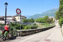
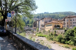
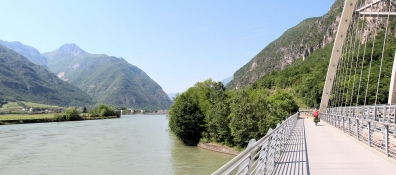
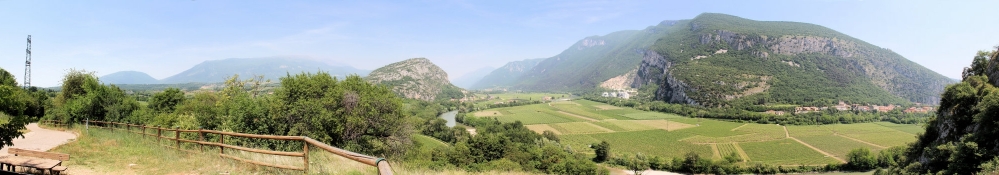
Das Frühstück heute Morgen war sehr vielfältig und reichlich. In der Stadt haben wir zuerst noch Besorgungen gemacht. Dann sind wir am Torrente Leno entlang zur Etsch geradelt. Der Radweg verläuft direkt am Flussufer. Nach Unterquerung der Brennerautobahn liegt am gegenüberliegenden Ufer das Einlassbauwerk für den Ableitungstunnel von der Etsch in den Gardasee. Er ist zum Hochwasserschutz an der unteren Etsch errichtet worden.

Information about copyright

Rights characteristic / license

by-sa: CREATIVE COMMONS Attribution-ShareAlike

Link to the description of the license

creativecommons.org/licenses/by-sa/3.0/

taken over / edited on

20 Jun 2022 - 09 Sep 2022

taken over / edited by

ThimbleU

On the Adige Valley Cycle Path between Marco and Chizolla

Information about copyright

Rights owner

ThimbleU

Rights characteristic / license

© all rights reserved.

Image has been uploaded

by ThimbleU on 20 Jun 2022

Chizolla

Information about copyright

Rights owner

ThimbleU

Rights characteristic / license

© all rights reserved.

Image has been uploaded

by ThimbleU on 20 Jun 2022

Santuano di San Valentir

Information about copyright

Rights owner

ThimbleU

Rights characteristic / license

© all rights reserved.

Image has been uploaded

by ThimbleU on 20 Jun 2022

On the Adige Valley cycle path near Santa Margherita (Ala)

Information about copyright

Rights owner

ThimbleU

Rights characteristic / license

© all rights reserved.

Image has been uploaded

by ThimbleU on 20 Jun 2022

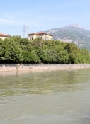
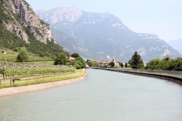
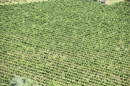
Wenig weiter queren wir bei Ravazzone ans rechte Ufer und radeln dann am Ufer eines Kanals entlang, rechts von uns liegen Weinfelder. Kurz vor Ende des Kanals führt der Weg wieder an das linke Ufer.

Information about copyright

Rights characteristic / license

by-sa: CREATIVE COMMONS Attribution-ShareAlike

Link to the description of the license

creativecommons.org/licenses/by-sa/3.0/

taken over / edited on

20 Jun 2022 - 09 Sep 2022

taken over / edited by

ThimbleU

On the Adige Valley cycle path near Santa Margherita (Ala)

Information about copyright

Rights owner

ThimbleU

Rights characteristic / license

© all rights reserved.

Image has been uploaded

by ThimbleU on 20 Jun 2022

On the Adige Valley cycle path near Ala

Information about copyright

Rights owner

ThimbleU

Rights characteristic / license

© all rights reserved.

Image has been uploaded

by ThimbleU on 20 Jun 2022

At the junction of the Canale Biffis from the Adige

Information about copyright

Rights owner

ThimbleU

Rights characteristic / license

© all rights reserved.

Image has been uploaded

by ThimbleU on 20 Jun 2022

House with beautiful roses near Sabbionara

Information about copyright

Rights owner

ThimbleU

Rights characteristic / license

© all rights reserved.

Image has been uploaded

by ThimbleU on 20 Jun 2022

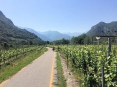
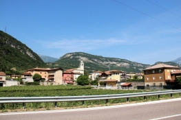
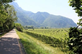
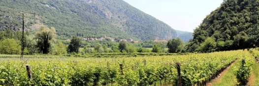
Erst unterhalb der Autobahn, dann neben der Bahnstrecke radeln wir mehrere Kilometer durch Weinfelder. Bei Serravalle wieder ein Wechsel des Ufers, die Weinfelder bleiben. Das Gelände wird für 1½ Kilometer ein wenig hügelig. Bis Borghetto bleiben wir fast immer nah an der Etsch.

Information about copyright

Rights characteristic / license

by-sa: CREATIVE COMMONS Attribution-ShareAlike

Link to the description of the license

creativecommons.org/licenses/by-sa/3.0/

taken over / edited on

20 Jun 2022 - 09 Sep 2022

taken over / edited by

ThimbleU

On the Adige Valley cycle path between Sabbionara and Belluno

Information about copyright

Rights owner

ThimbleU

Rights characteristic / license

© all rights reserved.

Image has been uploaded

by ThimbleU on 20 Jun 2022

On the Adige Valley cycle path between Sabbionara and Belluno

Information about copyright

Rights owner

ThimbleU

Rights characteristic / license

© all rights reserved.

Image has been uploaded

by ThimbleU on 20 Jun 2022

On the Adige Valley cycle path between Sabbionara and Belluno

Information about copyright

Rights owner

ThimbleU

Rights characteristic / license

© all rights reserved.

Image has been uploaded

by ThimbleU on 20 Jun 2022

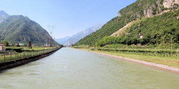
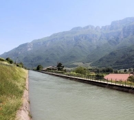
Dann folgen 600 Meter auf der Provinzialstraße und bei Mama di Sotto kommen wir an den Canale Biffis. Jetzt geht es für die nächsten zehn Kilometer fast ausschließlich an dessen Ufer entlang. In Praebocco verlassen wir den Kanal, der ab hier überwiegend durch Tunnel verläuft. Kurz hinter dem Ort finden wir einen schönen schattigen Rastplatz abseits der Straße.

Information about copyright

Rights characteristic / license

by-sa: CREATIVE COMMONS Attribution-ShareAlike

Link to the description of the license

creativecommons.org/licenses/by-sa/3.0/

taken over / edited on

09 Sep 2022

taken over / edited by

ThimbleU

At the wayside

Information about copyright

Rights owner

ThimbleU

Rights characteristic / license

© all rights reserved.

Image has been uploaded

by ThimbleU on 20 Jun 2022

In the Adige Valley at Mama di Sotto

Information about copyright

Rights owner

ThimbleU

Rights characteristic / license

© all rights reserved.

Image has been uploaded

by ThimbleU on 20 Jun 2022

Canale Biffis at Mama di Sotto

Information about copyright

Rights owner

ThimbleU

Rights characteristic / license

© all rights reserved.

Image has been uploaded

by ThimbleU on 20 Jun 2022

Canale Biffis before Belluno Veronese

Information about copyright

Rights owner

ThimbleU

Rights characteristic / license

© all rights reserved.

Image has been uploaded

by ThimbleU on 20 Jun 2022

Belluno Veronese

Information about copyright

Rights owner

ThimbleU

Rights characteristic / license

© all rights reserved.

Image has been uploaded

by ThimbleU on 20 Jun 2022

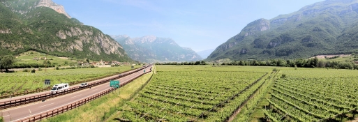
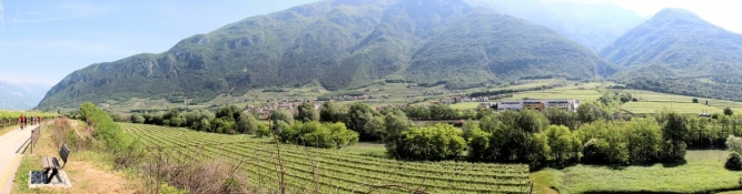
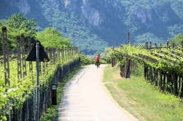
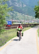
Der Radweg verläuft nun neben der Staatsstraße auf eigener Trasse. Lange Strecken sind wir auch wieder in Weinfeldern unterwegs.

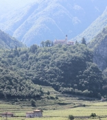
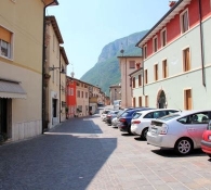
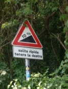
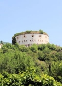
Dann kommt der Anstieg nach Rivoli Veronese. Rund 85 Höhenmeter sind es von der Etsch bis in den Ort. Nach ⅘ des Anstiegs in einer Spitzkehre ein Aussichtspunkt, von dem sich ein herrlicher Blick zurück ins Etschtal bietet. Dann erscheint über uns das Fort von Rivoli.

Information about copyright

Rights characteristic / license

by-sa: CREATIVE COMMONS Attribution-ShareAlike

Link to the description of the license

creativecommons.org/licenses/by-sa/3.0/

taken over / edited on

20 Jun 2022 - 09 Sep 2022

taken over / edited by

ThimbleU

In the Adige Valley below Rivoli Veronese

Information about copyright

Rights owner

ThimbleU

Rights characteristic / license

© all rights reserved.

Image has been uploaded

by ThimbleU on 20 Jun 2022

Ascent to Rivoli Veronese

Information about copyright

Rights owner

ThimbleU

Rights characteristic / license

© all rights reserved.

Image has been uploaded

by ThimbleU on 20 Jun 2022

View back to the Adige Valley

Information about copyright

Rights owner

ThimbleU

Rights characteristic / license

© all rights reserved.

Image has been uploaded

by ThimbleU on 20 Jun 2022

Vineyards in the Adige Valley

Information about copyright

Rights owner

ThimbleU

Rights characteristic / license

© all rights reserved.

Image has been uploaded

by ThimbleU on 20 Jun 2022

Fort of Rivoli

Information about copyright

Rights owner

ThimbleU

Rights characteristic / license

© all rights reserved.

Image has been uploaded

by ThimbleU on 20 Jun 2022

Rivoli Veronese

Information about copyright

Rights owner

ThimbleU

Rights characteristic / license

© all rights reserved.

Image has been uploaded

by ThimbleU on 20 Jun 2022

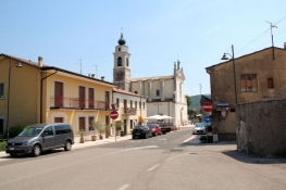
In Rivoli biegen wir vom EuroVelo 7 / Etschtalradweg ab und radeln rechts weiter Richtung Gardasee. Wir sind auf schmalen Nebenstraßen mit keinem bis geringem Verkehrsaufkommen unterwegs und es wird nun hügelig. Die nächsten zehn Kilometer geht es tendenziell bergauf. Bis zum höchsten Punkt des Tages oberhalb von Bardolino sind es mit Gegenanstiegen nochmals 150 Höhenmeter. Vom Gardasee ist noch nichts zu sehen.

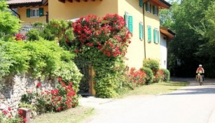
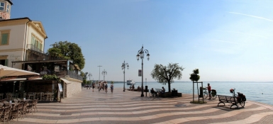
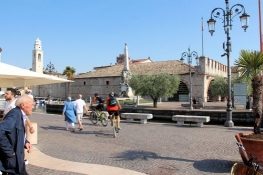
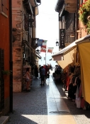
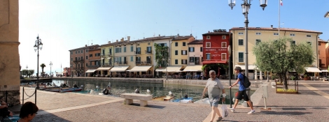
Aber wir rollen jetzt abwärts. Mit einigen Gegenanstiegen erreichen wir Lazise. Entlang der Seepromenade schieben wir die Räder bis zum alten Hafen und in den alten Ortskern. Ein paar Hunde genießen die Abkühlung im Seewasser. An der gegenüberliegenden Hafenseite das ehemalige Zollhaus und die Kirche San Nicolò. Wenig weiter das Castello di Lazise. Und alles fast ohne Touristen. Es ist noch früh im Jahr.

Information about copyright

Rights characteristic / license

by-sa: CREATIVE COMMONS Attribution-ShareAlike

Link to the description of the license

creativecommons.org/licenses/by-sa/3.0/

taken over / edited on

20 Jun 2022 - 09 Sep 2022

taken over / edited by

ThimbleU

On Lake Garda in Lazise

Information about copyright

Rights owner

ThimbleU

Rights characteristic / license

© all rights reserved.

Image has been uploaded

by ThimbleU on 20 Jun 2022

In Lazise

Information about copyright

Rights owner

ThimbleU

Rights characteristic / license

© all rights reserved.

Image has been uploaded

by ThimbleU on 20 Jun 2022

In Lazise

Information about copyright

Rights owner

ThimbleU

Rights characteristic / license

© all rights reserved.

Image has been uploaded

by ThimbleU on 20 Jun 2022

In Lazise

Information about copyright

Rights owner

ThimbleU

Rights characteristic / license

© all rights reserved.

Image has been uploaded

by ThimbleU on 20 Jun 2022

In Lazise

Information about copyright

Rights owner

ThimbleU

Rights characteristic / license

© all rights reserved.

Image has been uploaded

by ThimbleU on 20 Jun 2022

In Lazise

Information about copyright

Rights owner

ThimbleU

Rights characteristic / license

© all rights reserved.

Image has been uploaded

by ThimbleU on 20 Jun 2022

Between Lazise and Pacengo

Information about copyright

Rights owner

ThimbleU

Rights characteristic / license

© all rights reserved.

Image has been uploaded

by ThimbleU on 20 Jun 2022

Wir verlassen Laszise nach Osten. Leicht ansteigend radeln wir zurück auf den Hügelrücken oberhalb des Sees. Dann sind es noch acht Kilometer bis Pacengo. Hier haben wir unsere Unterkunft vorgebucht.

Information about copyright

Rights characteristic / license

by-sa: CREATIVE COMMONS Attribution-ShareAlike

Link to the description of the license

creativecommons.org/licenses/by-sa/3.0/

taken over / edited on

09 Sep 2022

taken over / edited by

ThimbleU