
Cycle Tour Prag nach Wien
Travel report
Actions
![]()
Please wait - map data are loading
Added on 16 Jul 2019,
last edited by KlausC on 19 Jul 2019
Actions
Cycle route metrics
planned
ridden
Total distance in km
382
384
Cumulative elevation gain in m
4.189
4.353
Avg. slope uphill in %
1,10
1,13
Cumulative elevation loss in m
4.224
4.423
Information about rights to the gps-track data | |
|---|---|
Rights owner | |
Rights characteristic / license | cc0: Public Domain no Rights reserved |
Link to the description of the license | |
GPX file uploaded | by KlausC on 16 Jul 2019
|
Track points in total
5.424
10.085
Track points per km (avg)
14
26
Start/endpoint
Start location
Prague, Prague, CZ (249 m NHN)
End location
, Wien, AT (214 m NHN)
Character
In Tschechien gute Radwege. Trotzdem Landstasse gefahren, da Autofahrer sehr entspannt und rücksichtsvoll.
In Österreich keine Bundesstrassen fahren, zu viel Verkehr und zu schnelles Fahren.
Information about copyright | |
|---|---|
Rights characteristic / license | by-sa: CREATIVE COMMONS Attribution-ShareAlike |
Link to the description of the license | |
taken over / edited on | 17 Jul 2019
|
taken over / edited by |
|
Landscape
Information about copyright | |
|---|---|
Rights characteristic / license | by-sa: CREATIVE COMMONS Attribution-ShareAlike |
Link to the description of the license | |
taken over / edited on | 17 Jul 2019
|
taken over / edited by |
|
Travel to and from ...
Mit Auto und einer Zwischenübernachtung in Pilsen nach Prag. Dort ein Hotel ausserhalb im Wohngebiet gebucht, da die Möglichkeit zum 2-wöchigen Parken besser war.
Mit dem Zug zurück nach Prag. Dort noch mal im gleichen Hotel übernachtet. Am nächsten Tag nonstop nach Hause.
Sources of information
Route geplant mit
http://brouter.de/brouter-web/#map=5/50.990/9.860/osm-mapnik-german_style
Auf dem Smartphone mit Locus pro navigiert.
Etappen wegen dem Energiemanagement mit Hilfe von https://www.ebikemaps.com/de/ geprüft.
Mit basecamp Strecken verwaltet.
Streckenidee von
__innatoura-polen.de_reiselaender_tschechien_radtour-von-.pdf
Stages
Beds4Cyclists, worth visiting and infrastructure
Name and address
Latitude / Longitude
Phone
Fax
Mobile
Type of accommodation
Rating for cyclists
Route km
Dist. to route
Elevation
0 km
0,0 km
245 m
0 km
4,2 km
237 m
0 km
4,1 km
264 m
Lebhafte Lokalszene abseites der Touristenströme mit Kneipen, Cafés und Restaurants sowie günstigen Geschäften.
Information about copyright | |
|---|---|
Rights characteristic / license | by-sa: CREATIVE COMMONS Attribution-ShareAlike |
Link to the description of the license | |
taken over / edited on | 12 Oct 2013
|
taken over / edited by |
|
1 km
3,6 km
258 m
11 km
0,2 km
286 m
Information about copyright | |
|---|---|
Rights owner | |
Rights characteristic / license | by-sa: CREATIVE COMMONS Attribution-ShareAlike |
Link to the description of the license | |
Image taken over from | |
Image has been uploaded | by biroto-Redaktion on 21 Dec 2012
|
Information about copyright | |
|---|---|
Rights owner | |
Rights characteristic / license | by: CREATIVE COMMONS Attribution |
Link to the description of the license | |
Image taken over from | |
Image has been uploaded | by biroto-Redaktion on 21 Dec 2012
|
Information about copyright | |
|---|---|
Rights owner | |
Rights characteristic / license | by: CREATIVE COMMONS Attribution |
Link to the description of the license | |
Image taken over from | commons.wikimedia.org/wiki/File:Průhonice,_zámecký_park,_prostranství_u_zámku.JPG |
Image has been uploaded | by biroto-Redaktion on 21 Dec 2012
|
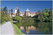
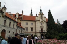
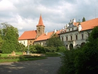
Das Schloss Průhonice (Pruhonitz) liegt in der Gemeinde Průhonice im Bezirk Prag-West in der Region Mittelböhmen in Tschechien, etwa 10 Kilometer von Prag ![]() entfernt.
entfernt.
Der Průhonicer Park steht als Nationaler Naturpark unter Schutz und wurde in die oberste Kategorie der Liste künftiger Weltkulturerbestättender UNESCO und in die Liste Historischer Gartenanlagen von ICOMOS ![]() aufgenommen.
aufgenommen.
Information about copyright | |
|---|---|
Rights characteristic / license | by-sa: CREATIVE COMMONS Attribution-ShareAlike |
Link to the description of the license | |
Input taken over from: |
Seite „Schloss Průhonice“. In: Wikipedia, Die freie Enzyklopädie. Bearbeitungsstand: 24. Juni 2011, 14:27 UTC. URL: http://de.wikipedia.org/w/index.php?title=Schloss_Pr%C5%AFhonice&oldid=90430612 (Abgerufen: 21. Dezember 2012, 17:19 UTC) |
taken over / edited on | 21 Dec 2012
|
taken over / edited by |
|
Hours of opening
| January | 8.00 - 17.00 |
| February | 8.00 - 17.00 |
| March | 7.00 - 18.00 |
| April | 7.00 - 19.00 |
| May | 7.00 - 20.00 |
| June | 7.00 - 20.00 |
| July | 7.00 - 20.00 |
| August | 7.00 - 20.00 |
| September | 7.00 - 20.00 |
| October | 7.00 - 19.00 |
| November | 8.00 - 17.00 |
| December | 8.00 - 17.00 |
![]()