
Cycle Tour Radrunde Wasserburg - Inzell - Zell am See - Walchsee - Wasserburg
Travel report
Actions
![]()
Please wait - map data are loading
Added on 04 Jul 2019,
last edited by Haplo on 09 Jul 2022
Actions
Cycle route metrics
planned
ridden
Total distance in km
300
0
Cumulative elevation gain in m
2.995
0
Avg. slope uphill in %
1,00
-
Cumulative elevation loss in m
2.898
0
Information about rights to the gps-track data | |
|---|---|
Rights owner | |
Rights characteristic / license | cc0: Public Domain no Rights reserved |
Link to the description of the license | |
GPX file uploaded | by ihmuc on 04 Jul 2019
|
Track points in total
5.612
0
Track points per km (avg)
19
0
Start/endpoint
Start location
Wasserburg am Inn, Bayern, DE (377 m NHN)
End location
Wasserburg am Inn, Bayern, DE (474 m NHN)
Character
Information about copyright | |
|---|---|
Rights characteristic / license | by-sa: CREATIVE COMMONS Attribution-ShareAlike |
Link to the description of the license | |
taken over / edited on | 04 Jul 2019
|
taken over / edited by |
|
Landscape
Information about copyright | |
|---|---|
Rights characteristic / license | by-sa: CREATIVE COMMONS Attribution-ShareAlike |
Link to the description of the license | |
taken over / edited on | 04 Jul 2019
|
taken over / edited by |
|
Travel to and from ...
Start- und Endpunkt der Bahnhof von Wasserburg am Inn (Reitmehring);
dorthin kann man mit dem Auto oder der Bahn fahren;
Connecting cycle path
z.B. der Innradweg oder auch der Tauernradweg.. und so einige mehr..
Remarks
Eine schöne Runde habe ich gedreht mit dem Fahrrad;
der erste Tag von Wasserburg nach Inzell ist geprägt vom ein oder anderen Auf und Ab im Endmoränen-Voralpen-Gebiet; hier habe ich nicht immer die optimale Wegeführung gefunden, da ich ein wenig grob mit einem Tool geplant hatte...;
der zweite Tag, von Inzell nach Zell am See, führt zumeist entlang der Alpenstraße im engen Taleinschnitt der Berge Richtung Süden; in weiten Teilen schöne Schotter- oder auch Asphaltwege; daneben jedoch auch die ein oder andere Passage auf der Straße; auch hier der ein oder andere Anstieg zu meistern:);
der dritte Tag dann von Zell am See nach Walchsee; hier habe ich den Weg über Leogang und dann zumeist auf aussichtsreichem Höhenweg mit Blick später dann auch den wilden Kaiser gewählt; zuerst recht schön, wenig Autoverkehr, dann ein Stück an der Hauptstraße, wenn man den kleinen Pass bewältigt hat, dann geht es stets weiter Auf und Ab, zumeist auf Schotterwegen; in St. Johann dann eine ganze Weile relativ flach gen Norden auf einem schönen Radweg; weil ich nicht straßennah fahren wollte, habe ich noch eine kleine 'Bergeinlage' kurz vor dem Abzweig nach Walchsee unternommen und bin zwischen den Paraglidern in Kössen herausgekommen; leider viel Verkehr in Walchsee, da Wochenende und Sonnenschein.. später dann kehrt Ruhe ein; der Ort leider doch recht an der Straße.. und der See daher, wenn man nicht den kleinen Streifen beim Seebad nimmt, nicht besonders zugänglich..;
zurück nach Wasserburg dann zuerst gemächlich ansteigend und eine feine Abfahrt! in das Inntal; dann eine gaaaanze Weile den Innradweg entlang; nur zur Mittagsrast ging es steil bergan;);
Beds4Cyclists, worth visiting and infrastructure
Name and address
Latitude / Longitude
Phone
Fax
Mobile
Type of accommodation
Rating for cyclists
Route km
Dist. to route
Elevation
6 km
0,5 km
428 m
32 km
0,2 km
534 m
Information about copyright | |
|---|---|
Rights owner | |
Rights characteristic / license | by-sa: CREATIVE COMMONS Attribution-ShareAlike |
Link to the description of the license | |
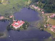
Image taken over from | https://commons.wikimedia.org/wiki/File:Aerials_Bavaria_16.06.2006_11-36-18.jpg |
Image has been uploaded | by biroto-Redaktion on 05 Jan 2019
|
Information about copyright | |
|---|---|
Rights owner | |
Rights characteristic / license | by-sa: CREATIVE COMMONS Attribution-ShareAlike |
Link to the description of the license | |
Image taken over from | |
Image has been uploaded | by biroto-Redaktion on 05 Jan 2019
|
Information about copyright | |
|---|---|
Rights owner | |
Rights characteristic / license | by-sa: CREATIVE COMMONS Attribution-ShareAlike |
Link to the description of the license | |
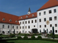
Image taken over from | https://commons.wikimedia.org/wiki/File:Kloster_Hof_mit_Brunnen_Seeon-2.jpg |
Image has been uploaded | by biroto-Redaktion on 05 Jan 2019
|
Information about copyright | |
|---|---|
Rights owner | |
Rights characteristic / license | by-sa: CREATIVE COMMONS Attribution-ShareAlike |
Link to the description of the license | |
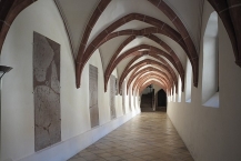
Image taken over from | https://commons.wikimedia.org/wiki/File:Klosterseeon_Kreuzgang_808.jpg |
Image has been uploaded | by biroto-Redaktion on 05 Jan 2019
|
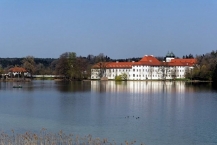
Seeon Abbey (German: Kloster Seeon) was a Benedictine monastery in the municipality of Seeon-Seebruck ![]() in the rural district of Traunstein in Bavaria, Germany.
in the rural district of Traunstein in Bavaria, Germany.
History
Seeon Abbey was founded in 994 by the Bavarian Pfalzgraf Aribo I, a member of the Aribonid dynasty, and settled by Benedictine monks from St. Emmeram's Abbey in Regensburg. The monastery is on an island in the lake Seeoner See, part of the present-day municipality of Seeon-Seebruck. The abbey soon developed a significant scriptorium, producing manuscripts not only for the abbey's own use but also for other monasteries and churches. Their most important client was Emperor Henry II, who presented many volumes to the Bishopric of Bamberg, which he had founded in 1007.
Toward the end of the 11th century the abbey church was re-built in the Romanesque style, but this building stood for only 100 years or so, before in about 1180 it was replaced by the present church, terminating in the east with an apse. More alterations in the late Gothic style were carried out between 1428 and 1433 by Konrad Pürkhel of Burghausen. The Romanesque basilica was given a vaulted ceiling and a new choir. In 1579 the church was decorated with unusual Renaissance frescoes, showing, alongside scenes from the life of Christ and the Virgin Mary, the patrons, Saints Benedict and Lambert, and the founders, Aribo and Adala. Also of special note is the red marble gravestone of Abbot Honorat Kolb and the gravestones of the abbots of the 15th and 16th centuries lined up against the walls of the castle chapel. In the middle stands the tomb of the founder, Count Aribo I, made by Hans Heider in about 1400. The restored cloisters are also worth seeing.
The original of the Madonna and Child (or the Seeoner Muttergottes, created in 1433 by the "Master of Seeon", as the anonymous artist is known) is considered one of the most beautiful representations of the subject. Since 1855 it has been in the Bavarian National Museum in Munich, but a copy has stood since 1947 on the high altar of the present parish church. The sacristy at Seeon contains a far older Madonna of about 1380.
The church originally had only one tower, that is, the north one, built to the model of that at Frauenchiemsee. The second tower was added at the end of the 12th century. The Romanesque towers are reminiscent of Freising Cathedral and, like the Frauenkirche at Munich, have copper "onion towers", which were added after a fire in 1561. Between 1657 and 1670 the church was extended by the construction of a sacristy in the Lady Chapel, an oratory and a crypt beneath the chapel of Saint Barbara.
Until the secularisation of Bavaria in 1803 Seeon was a place of learning and culture: Joseph Haydn was a guest here, and Mozart was active here between 1767 and 1769.
After 1803 the abbey was dissolved and the buildings were turned into a castle, and used later at various times as a medicinal spa, convalescent home and barracks. The infirmary and the library were demolished, and a causeway constructed connecting the island to the mainland.
In 1989 the premises were eventually acquired by the government of the administrative region of Oberbayern and after a lengthy restoration reopened in 1993 as a cultural and educational centre, which is now used for concerts, exhibitions, seminars, conferences and workshops.
Information about copyright | |
|---|---|
Rights characteristic / license | by-sa: CREATIVE COMMONS Attribution-ShareAlike |
Link to the description of the license | |
Input taken over from: |
Wikipedia contributors, 'Seeon Abbey', Wikipedia, The Free Encyclopedia, 15 February 2018, 05:29 UTC, <https://en.wikipedia.org/w/index.php?title=Seeon_Abbey&oldid=825750440> [accessed 5 January 2019] |
taken over / edited on | 05 Jan 2019
|
taken over / edited by |
|
53 km
1,1 km
608 m
53 km
0,5 km
602 m
Information about copyright | |
|---|---|
Rights owner | |
Rights characteristic / license | © all rights reserved. |
Image has been uploaded | by biroto-Redaktion on 01 Jan 2012
|
Information about copyright | |
|---|---|
Rights owner | |
Rights characteristic / license | by-sa: CREATIVE COMMONS Attribution-ShareAlike |
Link to the description of the license | |
Image taken over from | commons.wikimedia.org/wiki/File:Stadtplatz_Traunstein_-_geo.hlipp.de_-_10211.jpg |
Image has been uploaded | by biroto-Redaktion on 01 Jan 2012
|
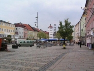
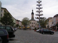
Traunstein liegt an der Traun und ist Zentrum des Chiemgaus.
Hintergrund
Das Jahr der erstmaligen urkundlichen Erwähnung ist 1245, Traunstein gehört noch zu Salzburg ![]() , aber bereits ab 1275 zu Bayern.
, aber bereits ab 1275 zu Bayern.
Im Mittelalter hat die Stadt Bedeutung durch ihre Lage an der Salzhandelsroute und war recht wohlhabend, blieb aber trotzdem von den Wirren des dreißigjährigen Krieges (1618–1648) weitgehend verschont.
Markanter wirtschaftlicher Einschnitt war die Verstaatlichung des freien Salzhandels im Jahre 1587, der Bau einer Soleleitung von Reichenhall ![]() nach Traunstein und der Bau einer eigenen Saline zur Salzproduktion in den Jahren 1616 bis 1619 milderten die Folgen.
nach Traunstein und der Bau einer eigenen Saline zur Salzproduktion in den Jahren 1616 bis 1619 milderten die Folgen.
Belegt sind große Stadtbrände in den Jahren 1704 (durch ungarische Panduren in Folge des spanischen Erbfolgekrieges) und der von 1851 ohne geklärte Ursache, ein angeblicher Stadtbrand im Jahre 1400 ist in der Wissenschaft umstritten.
Der hohe Stellenwert von Brauchtum und Kultur zeigt sich in der ortsansässigen Gebirgsschützenkompanie, dem Trachtenverein und der Gemeindeblasmusikkapelle und weiteren Kulturvereinen.
Mit über 14.000 Arbeitsplätzen ist Traunstein heute auch wichtiger Gewerbestandort der Region.
Besonders stolz ist die Stadt als "Vaterstadt" von Papst Benedikt XVI.: Joseph Ratzinger verbrachte seine Jugend in Traunstein, ging hier zur Schule und feierte seine Primiz in der Pfarrkirche St. Oswald.
Sehenswürdigkeiten
Kirchen
- ⊙Pfarrkirche St. Oswald, Maxplatz 8, 83278 Traunstein. Eine Kirche St. Oswald wird bereits 1342 erstmals erwähnt; der jetzige barocke Bau entstand 1675 – 77 unter den Graubündener Meistern Caspar Zuccalli, Lorenzo Sciasca und Antonio Riva.
- ⊙Klosterkirche, Ludwigstr. 10. Kirche des ehemaligen Kapuzinerklosters Traunstein (1805 in der Säkularisierung aufgelöst): "Kunstraum Klosterkirche" für Konzerte und Kunstausstellungen.
- ⊙St. Rupert und Maximilian, Karl-Theodor-Platz 1. Erbaut um 1630.
- ⊙St. Georg und Katharina, Ludwigstraße 19. Ehemalige Friedhofskirche.
Bauwerke
- ⊙Rathaus
- ⊙Jacklturm, Teil der Befestigung der Stadt, 1851 beim Stadtbrand zerstört, 1998 in historischer Form wiederhergestellt.
- ⊙Salinenkapelle ("größte Kapelle in Deutschlands") und Salinenhäuser (1786/87 fertiggestellt, 1912 aufgelassen) in der Au.
- ⊙Jugendstilhaus: Bahnhofstraße 16, preisgekrönter Entwurf der Architekten und Baumeister Josef und Sebastian Polz.
Museen
- ⊙Brauereimuseum (Hofbräuhaus Traunstein, zur über 375-jährigen Geschichte der Brauerei, Brauereiführungen), Hofgasse 5-11, 83278 Traunstein (nähe Stadtplatz). ☎ +49 861 98866 42.
- ⊙Druckereimuseum (beim Traunsteiner Tagblatt; Druckgeschichte von Gutenberg bis heute), Marienstraße 12, 83278 Traunstein. ☎ +49 861 9877 0. Geöffnet: Mittwochs: 14 bis 16 Uhr.
- ⊙Heimathaus Traunstein (stadtgeschichtliche Sammlungen und Spielzeugmuseum), Stadtplatz 2-3, 83278 Traunstein. ☎ +49 861 164786. Geöffnet: Apr. bis Okt. und im Advent: Mo-Sa: 10-15 Uhr So.: 10-16 Uhr. Preis: Eintritt Erwachsene: 3.-€, Kinder 2.-€.
Straßen und Plätze
- Stadtplatz mit Lindlbrunnen aus dem Jahre 1526.
Küche
- ⊙Hofbräuhaus Traunstein, Bräustüberl, Stadtplatz 20, 83278 Traunstein. ☎ +49 861 4379. Regionale Spezialitäten, Biergarten.
- ⊙Wochinger Bräu, Brauereigasthaus, Oswaldstraße 4, 83278 Traunstein. ☎ +49 861 3045. Regionale und mediterranen Spezialitäten, Biergarten.
- ⊙Brauerei-Ausschank Schnitzlbaumer, Taubenmarkt 11a-13, 83278 Traunstein. ☎ +49 861 98665 0. Regionale Küche. Geöffnet: täglich ab 9 Uhr.
Information about copyright | |
|---|---|
Rights characteristic / license | by-sa: CREATIVE COMMONS Attribution-ShareAlike |
Link to the description of the license | |
Input taken over from: |
Wikivoyage-Bearbeiter, 'Traunstein', Wikivoyage, Freie Reiseinformationen rund um die Welt, 16. Mai 2020, 12:33 UTC, https://de.wikivoyage.org/w/index.php?title=Traunstein&oldid=1299281 |
taken over / edited on | 01 Jan 2012 - 17 May 2021
|
taken over / edited by |
|
60 km
0,0 km
596 m
Information about copyright | |
|---|---|
Rights owner | von Lou.gruber (Eigenes Werk) [Public domain], durch Wikimedia Commons |
Rights characteristic / license | by: CREATIVE COMMONS Attribution |
Link to the description of the license | |
Image taken over from | |
Image has been uploaded | by biroto-Redaktion on 01 Jan 2012
|
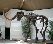
Das Museum widmet sich als Erlebnismuseum der Erdgeschichte Südostbayerns und vermittelt die Entstehung der regionalen Landschaft am Beispiel des Chiemgaus.
Information about copyright | |
|---|---|
Rights characteristic / license | by-sa: CREATIVE COMMONS Attribution-ShareAlike |
Link to the description of the license | |
taken over / edited on | 01 Jan 2012 - 06 Mar 2012
|
taken over / edited by |
|
Hours of opening
April-Oct.: Tu.-So. 10.00-18.00, 20.
Dec.-March: We, Sa, Su. a. public holidays 10.00-17.00
![]()