
Cycle Tour Saar-Nahe-Glan-Blies-Circle
Trike Prims - Saar: Gonnesweiler - Saarbrücken-Brebach
![]()
Please wait - map data are loading
Added on 07 Dec 2015
last edited by Westerwaldradler on 07 Dec 2015
Cycle route metrics
ridden
Total distance in km
88
Cumulative elevation gain in m
454
Avg. slope uphill in %
0,52
Cumulative elevation loss in m
630
Total cycling hours
6,5
Avg. pace in km/h
13,5
Min. height
180
Max. height
466
Information about rights to the gps-track data | |
|---|---|
Rights owner | |
Rights characteristic / license | by-sa: CREATIVE COMMONS Attribution-ShareAlike |
Link to the description of the license | |
GPX file uploaded | by InduKult on 07 Dec 2015
|
Track points in total
1.028
Track points per km (avg)
12
Start/endpoint
Start location
Nohfelden, Saarland, DE (372 m NHN)
End location
Saarbrücken, Saarland, DE (196 m NHN)
ridden on
20 Apr 2011
Weather
Sonne, 13 bis 24°, 91 km
Accommodation
Hotel Fährhaus
Zur Alten Fähre 1
DE-66130 Saarbrücken-Brebach
Travel report
Mittwoch, 20.04.2011 Trike Nahe - Prims - Saar
Sonne, 13 bis 24°, 91 km
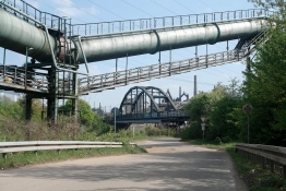
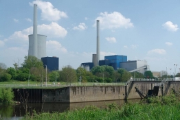
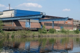
Zunächst ist heute die Überwindung der Wasserscheide Nahe-Prims angesetzt. Ich fahre diesmal Straße, und nach einigen Höhenmetern ist das geschafft. Eine lange steile Abfahrt führt zur Gemeinde Primstal hinunter. Dort für 6 km schöne ex-Bahntrasse als Radweg bis Wadern. Auch die nächsten paar km noch auf eigenem Radweg. Dann ist das Vergnügen aber zu Ende. Ich muss viel Straße fahren, zum Schluss die die Bundesstraße nach Dillingen auf Radweg hinter der mächtigen Leitplanke. Dafür dort etwas Kokereiduft, Salat und Trinken in Kneipe am östlichen Ortsende. Durch die Stadt hindurch erreiche ich den Saar-Radweg, der auf dem asphaltierten Wirtschaftsweg der Bundeswasserstraßen-Verwaltung fast stets zwischen Kanal und Autobahn 620 verläuft. Teils sehr technisch mit viel Beton ausgebaut, passend zur rustikalen Industrielandschaft, meist am Nordufer. Stationen sind
- Hafen der Dillinger Hütte
- Kraftwerk Ensdorf
- Stahlwerk (und ex-Röhrenwerk) Bous
- Saarstahl zwischen Bous und Völklingen
- Hütte Völklingen
- Burbacher Hütte
- Brachflächen-Parks in Saarbrücken
- Innenstadt Saarbrücken mit Bauarbeiten an neuer Fluss-Promenade, aus der ein zig-Mio.-Projekt mit teilweise Überdeckelung der Autobahn werden soll, die hier tatsächlich mitten durch die Stadt führt
- Gas-Kraftwerk Saarbrücken.
Schließlich wechsele ich über die Saar, um das vorhin telef. reservierte Hotel „Fährhaus“ im Stadtteil Brebach anzusteuern. Hier lässt mich erstmals die openfietsmap im Stich: statt über Radwege geht es über Trampelpfade auf einer großen Brachfläche, die im Zuge der Saar-Kanalsierung entstanden ist. Indiz für den Saar-Umbau ist der Name des Hotels "Altes Fährhaus", das heute 1 km von der Saar entfernt liegt. Wirtin ist eine junge Polin, die das Trike als begeisterte Radlerin sofort ausprobiert.
Information about copyright | |
|---|---|
Rights characteristic / license | by-sa: CREATIVE COMMONS Attribution-ShareAlike |
Link to the description of the license | |
taken over / edited on | 07 Dec 2015
|
taken over / edited by |
|
Information about copyright | |
|---|---|
Rights owner | |
Rights characteristic / license | by-sa: CREATIVE COMMONS Attribution-ShareAlike |
Link to the description of the license | |
Image has been uploaded | by InduKult on 07 Dec 2015
|
Information about copyright | |
|---|---|
Rights owner | |
Rights characteristic / license | by-sa: CREATIVE COMMONS Attribution-ShareAlike |
Link to the description of the license | |
Image has been uploaded | by InduKult on 07 Dec 2015
|
Information about copyright | |
|---|---|
Rights owner | |
Rights characteristic / license | by-sa: CREATIVE COMMONS Attribution-ShareAlike |
Link to the description of the license | |
Image has been uploaded | by InduKult on 07 Dec 2015
|
Information about copyright | |
|---|---|
Rights owner | |
Rights characteristic / license | by-sa: CREATIVE COMMONS Attribution-ShareAlike |
Link to the description of the license | |
Image has been uploaded | by InduKult on 07 Dec 2015
|
Information about copyright | |
|---|---|
Rights owner | |
Rights characteristic / license | by-sa: CREATIVE COMMONS Attribution-ShareAlike |
Link to the description of the license | |
Image has been uploaded | by InduKult on 07 Dec 2015
|
Information about copyright | |
|---|---|
Rights owner | |
Rights characteristic / license | by-sa: CREATIVE COMMONS Attribution-ShareAlike |
Link to the description of the license | |
Image has been uploaded | by InduKult on 07 Dec 2015
|