
Cycle Tour The Channel Tour
Dag 8: Portsmouth-Quineville
![]()
Please wait - map data are loading
Added on 23 Jun 2015
last edited by Ottocolor on 13 Oct 2018
Cycle route metrics
ridden
Total distance in km
66
Cumulative elevation gain in m
732
Avg. slope uphill in %
1,11
Cumulative elevation loss in m
746
Min. height
1
Max. height
56
Information about rights to the gps-track data | |
|---|---|
Rights owner | |
Rights characteristic / license | by-sa: CREATIVE COMMONS Attribution-ShareAlike |
Link to the description of the license | |
GPX file uploaded | by Ottocolor on 25 Jun 2015
|
Track points in total
505
Track points per km (avg)
8
Start/endpoint
Start location
Portsmouth, England, GB (15 m NHN)
End location
Quinéville, Normandy, FR (8 m NHN)
ridden on
16 Jun 2015
Weather
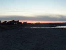
Fair sunny summer weather and warm temperatures all day. Around noon somewhat too hot. Incredibly beautiful evening sun. Light westerly wind, thus a niche tailwind most of the day.
Accommodation
La Sinope
10 Rue du Port Sinope
FR-50310 Quinéville-La Manche
Properties
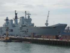
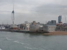
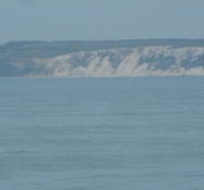
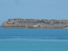
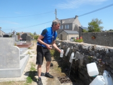
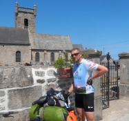
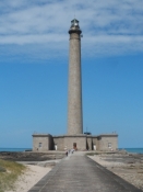
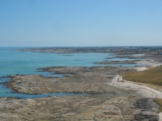
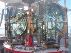
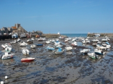
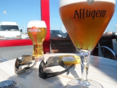
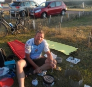
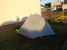
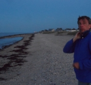
Early morningride to the international ferry port past the working naval base in Portsmouth - The ferry port with the ferry to Cherbourg - A fast going ferry out of Spithead, past Isle of Wight and cross the Channel, up to 68 kmph - Arrival to the huge port of Cherbourg - Along the coast in slightly hilly terrain - We're in need of water, look in vain at Fermanville, but find some at a church in Néville-sur-Mer - A long break with coffe making at the lighthouse of Phare de Gatteville - Barfleur with a completely dried out harbour with boats standing on the ground - Beer break in Saint-Vaast-la-Hogue with shopping for supper at a small butchery - Empty coast road to the stage goal at Quineville - Camp site near the beach, where we fry bangers and warm potato mash and wash our clothes.
Slope Gradient Distribution
Travel report
Information about copyright | |
|---|---|
Rights owner | |
Rights characteristic / license | by-sa: CREATIVE COMMONS Attribution-ShareAlike |
Link to the description of the license | |
Image has been uploaded | by on 31 Jul 2015
|
Information about copyright | |
|---|---|
Rights owner | |
Rights characteristic / license | by-sa: CREATIVE COMMONS Attribution-ShareAlike |
Link to the description of the license | |
Image has been uploaded | by on 31 Jul 2015
|
Information about copyright | |
|---|---|
Rights owner | |
Rights characteristic / license | by-sa: CREATIVE COMMONS Attribution-ShareAlike |
Link to the description of the license | |
Image has been uploaded | by on 31 Jul 2015
|
Information about copyright | |
|---|---|
Rights owner | |
Rights characteristic / license | by-sa: CREATIVE COMMONS Attribution-ShareAlike |
Link to the description of the license | |
Image has been uploaded | by on 31 Jul 2015
|
Information about copyright | |
|---|---|
Rights owner | |
Rights characteristic / license | by-sa: CREATIVE COMMONS Attribution-ShareAlike |
Link to the description of the license | |
Image has been uploaded | by on 31 Jul 2015
|
Information about copyright | |
|---|---|
Rights owner | |
Rights characteristic / license | by-sa: CREATIVE COMMONS Attribution-ShareAlike |
Link to the description of the license | |
Image has been uploaded | by on 31 Jul 2015
|
Information about copyright | |
|---|---|
Rights owner | |
Rights characteristic / license | by-sa: CREATIVE COMMONS Attribution-ShareAlike |
Link to the description of the license | |
Image has been uploaded | by on 31 Jul 2015
|
Information about copyright | |
|---|---|
Rights owner | |
Rights characteristic / license | by-sa: CREATIVE COMMONS Attribution-ShareAlike |
Link to the description of the license | |
Image has been uploaded | by on 31 Jul 2015
|
Information about copyright | |
|---|---|
Rights owner | |
Rights characteristic / license | by-sa: CREATIVE COMMONS Attribution-ShareAlike |
Link to the description of the license | |
Image has been uploaded | by on 31 Jul 2015
|
Information about copyright | |
|---|---|
Rights owner | |
Rights characteristic / license | by-sa: CREATIVE COMMONS Attribution-ShareAlike |
Link to the description of the license | |
Image has been uploaded | by Ottocolor on 31 Jul 2015
|
Information about copyright | |
|---|---|
Rights owner | |
Rights characteristic / license | by-sa: CREATIVE COMMONS Attribution-ShareAlike |
Link to the description of the license | |
Image has been uploaded | by Ottocolor on 31 Jul 2015
|
Information about copyright | |
|---|---|
Rights owner | |
Rights characteristic / license | by-sa: CREATIVE COMMONS Attribution-ShareAlike |
Link to the description of the license | |
Image has been uploaded | by Ottocolor on 31 Jul 2015
|
Information about copyright | |
|---|---|
Rights owner | |
Rights characteristic / license | by-sa: CREATIVE COMMONS Attribution-ShareAlike |
Link to the description of the license | |
Image has been uploaded | by Ottocolor on 31 Jul 2015
|
Information about copyright | |
|---|---|
Rights owner | |
Rights characteristic / license | by-sa: CREATIVE COMMONS Attribution-ShareAlike |
Link to the description of the license | |
Image has been uploaded | by Ottocolor on 31 Jul 2015
|
Information about copyright | |
|---|---|
Rights owner | |
Rights characteristic / license | by-sa: CREATIVE COMMONS Attribution-ShareAlike |
Link to the description of the license | |
Image has been uploaded | by Ottocolor on 31 Jul 2015
|