
Radtour Englische Kanal-Rundfahrt
Reisebericht: Brussels-Brugge-Dunkerque-Dover-Portsmouth-Cherbourg-Bayeux-Caen-Brussels
Aktionen
![]()
Bitte warten - Kartendaten werden geladen
Erstellt am 16.01.2014,
zuletzt geändert von Ottocolor am 15.08.2015
Aktionen
Strecken-Merkmale
geplant
gefahren
Gesamtlänge in km
596
712
Gesamthöhenmeter Aufstieg
3.806
5.652
Durchschn. Steigung Aufstieg %
0,64
0,79
Gesamthöhenmeter Abstieg
3.806
5.567
Informationen zu Rechten an den GPS-Track-Daten | |
|---|---|
Rechte-Inhaber | |
Rechte-Ausprägung / Lizenz | by-sa: CREATIVE COMMONS Namensnennung, Weitergabe unter gleichen Bedingungen |
Link zur Rechtebeschreibung | |
gpx-Datei hochgeladen | durch Ottocolor am 07.06.2015
|
Gesamtzahl Trackpoints
7.435
9.594
Trackpoint-Dichte per km
9
13
Endorte
Start
Bruges, Flanders, BE (9 m NHN)
Ziel
Caen, Lower Normandy, FR (9 m NHN)
Charakter
Twelve day cycling holiday along with Kolya. Ridden in June 2015. Overall subject: Two invasions: The Normal conquest of the British isles in 1066 and the Allied troops counterpart in the opposite direction 878 years later.
Airtrip Billund-Brussels and bicycle hire in Brussels. Train journey to Bruges and on the return from Caen to Brussels with short bike stretches in Paris and across the French/Belgian border.
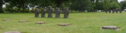
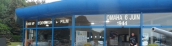
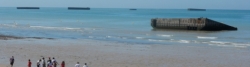
The bike holiday can be divided into three parts. The first part (112 km) from Bruges to Dunkirk. Ferry Dunkirk - Dover. The second part in England (301 km) from Dover to Portsmouth peaks in Hastings, Battle and Brighton. Ferry Portsmouth - Cherbourg. The third part of the bike holiday in France from Cherbourg to Caen (231 km) is devoted to the D-Day beaches of Normandy. Highlights are the Utah beach museum, the German War Cemetary La Cambe, Pointe du Hoc, the Omaha Beach Monument and museum, the American War Cemetary at Coleville-sur-Mer, the British War Cemetary at Bayeux, The Musée de Tapisserie with the Bayeux Tapestry, the German coastal battery in Longues-sur-Mer and the Musée d'Embarcation in Arromanches-les-Bains. From there on to Caen. From Caen by train to Brussels with shift in Paris, Maubeuge and Mons. Final sightseeing day in Brussels before the flight home the same evening.
Distances/countries: Belgium 70 km, 10%, France 279 km (48+231) 44%, England 301 km (46%).
Informationen zu Urheber-Rechten | |
|---|---|
Rechte-Ausprägung / Lizenz | by-sa: CREATIVE COMMONS Namensnennung, Weitergabe unter gleichen Bedingungen |
Link zur Rechtebeschreibung | |
übernommen / bearbeitet am | 19.01.2014 - 12.08.2015
|
übernommen / bearbeitet durch |
|
Landschaft
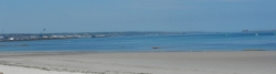
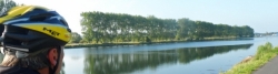
For the most part we cycled through coastal landscape in Belgium, England and France. In Belgium it's often a densely populated seaside resorts with a beach promenade between large dune landscapes. In England we encountered a chalk cliff coast, went along an old military canal further inland, through large marshlands with lots of sheep, typically English, densely populated coastal landscape either with large rolling green hills around Hastings and between Eastbourne and Brighton or flat as west of Brighton. Estuaries, strongly affected by the large tidal range and canals with low islands (lagoon coast) east of Portsmouth. In France, much less densely populated rocky coastline and a vast tidal zone with mudflats and drained ports at low tide. The landscape of the D-Day beaches had quite different character. Utah beach completely flat with large (during the war flooded) marshes behind the beach, Omaha and Gold beaches with high clay cliffs behind a flat beach and finally again a flat, sandy coast landscape around Juno and Sword beaches. The large, wide, completely flat and roadless estuary landscape north of Carentan is remarkable. Characteristic are also the many hedges between the fields of Normandy, the so-called bocage landscape, formed back in the Celtic period approximately 2,000 years ago. This unacessible landscape caused special difficulties for the Allied troops, engaged in the battle of Normandy.
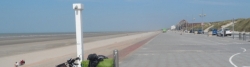
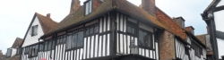
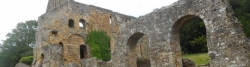
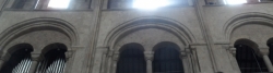
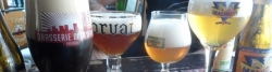
Towns and cities: We visited exciting and very different towns and cities like the former enterprising marsh town of Bruges, which in many respects resembles the Danish town of Ribe's fate when the estuary sanded up, and new ports were built, respectively Zeebrugge and Esbjerg, after which the old towns were left to keep their old houses in the downturn. Ostend is a typical large seaside resort with designed beach entertainment programs. Dunkirk is a town, almost a city, on the French part of the Flemish coast. Dunkirk is the English version of the French Dunkerque, a French pronunciation of Duinkerke (dune church). On the Belgian side of the border a town is still named Oost-Duinkerke. It has a very large port with a coastal fort from the 1700s, later expanded strongly. The city of Dover on the English side of the Channel also thrives mainly by its large port, but was once a fashionable seaside resort. Today, it has, however, lost much of its elegance to competing resorts, and nightlife, apart from a single noisy disco, is non-existing, we had to recognize. Here, as almost all the way to Portsmouth the beach consists of small to medium-sized pebbles, called shingles. Like tre one we slept on in Dover due to lack of late night accomodation possibilites.Sandy beaches are quite rare. Folkstone is keen to preserve the memory of the fallen British soldiers from the last world war and has an excellent shopping street. The most beautiful of all the towns on the south coast of England is Rye. Really well-preserved half-timbered houses and a genuine old small town atmosphere. The latter Hastings, to some extent has lost, but the hilly town has other virtues like a charming fishing port where the rather large steel cutters are still pulled up on the rather steep beach. An operation that must require a considerable force and an extremely strong steel wire. William the Conqueror's castle high above the city is highly derelict, but still impressive. Large parts of it have slid down the cliff and into the town over the centuries. Battle is a town, as the name reveals, that completely owes it existence to the Battle of Hastings October 24, 1066. After the battle, the place of it was heroised by the Normans in the way that a very large monastery, Battle Abbey, was erected here. It is partially much better preserved than the castle in Hastings, especially the hall of the novices, which stands virtually untouched since late 11th century. The coast from Pevensey, where the Norman fleet landed in September 1066, to Eastbourne is characterized by densely populated seaside resorts, more or less charming, but all with a wide beach promenade, which cyclists and pedestrians have to share, either with or without markings of cycle paths. In the Eastbourne the bicycle route runs further up behind the beach and the coast here and all the way to Brighton is very hilly. Brighton is a large coastal city with a famous bathing and leisure life. Everything is very big and very expensive and the original, natural character has been completely lost in tourist crowd. The city has Europe's largest marina, which in itself is a city within the city with all possible facilities you can think of. Brighton amusement pier is world famous for its rides. To me it seemed quite tacky. Worthing is an example of a less successful and therefore more original Southern English seaside resort with an old steel pier which appears something more real in its appearance. Though the amusements are tacky here as well. In the small coast towns summer life is enjoyed to the full with barbecues on vast grasslands and games of cricket on the manicured English lawns. The ports along the estuaries, as in Shoreham and Littlehampton are charming and the tide play an essential role in their operation. A lovely middlesized town Chichester turned out to be. A superb setting amidst quiet meadows at a charming old canal, many well-kept old houses and then there's the cathedral! Truly a beautiful and perfect old church. There's also a museum with allegedly very well preserved remnants of a Roman bath, but alas, time did not allow a visit there. The old naval city of Portsmouth is a strange mixture of old and new. This can be done in a charming way, but here it looks a downright failure, too, because the old buildings are not maintained well enough. New constructions as the colossal Spinnaker tower (which completely moronicly closes at. 6pm!) and the Gunwharf area are trying to give the city a modern look, but it fits poorly with the big, clumsy railway station just beside. A pub visitor allowed himself to call Portsmout a 'shithole'. That's harshly put, but not totally undeserved. They got it wrong in this city. Naval tradition lives on in the historic docklands area, while the modern naval port takes a good part of the city and the waterfront. The natural location by the river port Spithead has given Britain's fleet which previously 'ruled the waves', a stunning stronghold here. With the chalk cliffs on the Isle of Wight to starboard we said goodbye to England on the fast ferry Normandy Express and two hours later hello to France with the huge deep-water port of Cherbourg. This town at the tip of the Cotentin Peninsula was absolutely essential in the Allied conquest of France and afterwards the rest of Europe during the second world war, and was therefore hard fought over. Especially the Americans were addicted to conquer the port to obtain supplies across the Channel. The small coastal towns with their small boat harbours, at low tide totally fallow, as Barfleur, Saint-Vaast-la-Hogue and Quineville. This is very charming and they have a good trade behind the rather busy and congested coastal road. After Quineville the D-Day beaches began to dominate with a wealth of museums and memorials in honour of the Allied invasion in June 1944. The tourist flow, especially in the month of June each year, puts its stamp on the towns and villages and any bar with respect for itself calls itself " 6-June-bar "or something in that style. The paratroopers capital near Utah beach at Saint-Marie-du-Mont, which really is on a 'mountain', is the hallmark here. Carentan is larger but more characterless. Beautiful and original appears Isigny-sur-Mer. The last two words all coastal resorts are vying to have in their name, as it sports the location by the sea and implicitly shows tourists the way to relaxation and good service. As the most beautiful coastal town in Lower Normandy, however, we appoint Arromanches-les-Bains (means Spa A.). The most beautiful town of all on our French route is unquestionably Bayeux with its almost a thousand year old beautiful cathedral, an intact medieval atmosphere and of course the fascinating, incomparable tapestry, which in fact is not a tapestry but an embroidery. It is 85 meters long and made shortly after William the Conqueror's conquest in 1066 as a unique Norman propaganda work in support of the invasion and the extremely violent subjugation of England. The key is English King Harold's fraud by himself receiving the English crown, which he, allegedly, had promised to the Norman Duke William (Guillaume in French). "We'll teach him a lesson" is the tone that shines through the tapestry. And so they did. One of the scenes has the Latin inscription: "Hic Harold interfectus est". ("Here Harold is killed") Inspired by this tapestry the D-Day Museum in Portsmouth has a D-Day embroidery exhibited, of course depicting the 'second invasion' of 1944. Obviously, we had plans about studying this work of art also, but a ferry out of service between Hayling island and Portsmouth made this impossible. So another (brilliant or crazy?) comparison between the two invasions must stand in as a link between the events, namely the inscription of the monument at the British War Cemetery in Bayeux. In Latin is written NOS A GULIELMO VICTI VICTORIS PATRIAM LIBERAVIMUS. In English: WE, ONCE DEFEATED BY WILLIAM, HAVE NOW LIBERATED THE VICTOR'S HOMELAND. As Kolja noted: A typically British, narrow-minded and self-fixated position. In any case, the ring thus closed, and we could finally make for our long journey home, not without enjoying the comforts of Europe's unofficial capital Brussels, which in French is called Bruxelles. Originally it is a Flemish city, but as all communication in the Napoleonic era, when the city became the capital of the newly monarchy Belgium, was in French, the townspeople gradually 'forgot' their ancient mother tongue, and therefore it today is predominantly Francophone. But not for me. Brussel! Thank you. European 'capital' it is of the course because of its many European institutions, of which the most important are the EU parliament (which it by the typical EU-logical gluttony, has to share with Strasbourg in France), the European Commission (Europe's "Government") and the EU Council, the former Council of Ministers, where all ministers of the 27 member states have a seat and an office. That means, it requires a huge building. The city of Brussels itself is exceedingly attractive, and it is full of delicious food and especially delicious drinks! Here life is lived to the full. That is, if you like city life, and cyclists are excellently treated. Bicycle paths everywhere, and cyclists are mostly allowed to ride against the traffic in one-way streets. But the main station, Centraal Station, is closed to cyclists. Use the North Station or South Station (Zuid station or Gare du Midi), if you need to take a bike on the train.
At last a note about camping in England and France respectively. England's the light camper's nightmare, while France is his paradise. It's that different! In England the camp site is almost everywhere placed without logic to where you woud expect it to be, i.e. near the coast or the town/city centre. The signposting leading to it is from very poor to non-existent. Prices are very high. Often they are full during high season, even for a small tent. The service is often exaggerated and useless for light campers. And, obviously, you don't meet many other tentpeople on them. Distances between them are long. In France camp sites are strewn generously along the coastline. They are mostly small and cosy and well equipped with a laundry and a small shop. The staff is friendly and helpful, but almost nobody speaks English. Prices are from very reasonable to downright cheap. They're easily found as signposting is excellent. In both England and France watch out for thieves: Twice I had my battery recharger with batteries for my GPS stolen from sanitary buildings.
Informationen zu Urheber-Rechten | |
|---|---|
Rechte-Ausprägung / Lizenz | by-sa: CREATIVE COMMONS Namensnennung, Weitergabe unter gleichen Bedingungen |
Link zur Rechtebeschreibung | |
übernommen / bearbeitet am | 12.08.2015 - 15.08.2015
|
übernommen / bearbeitet durch |
|
Informations-Quellen
The Norman conquest of England 1066:
Etappen

Informationen zu Urheber-Rechten | |
|---|---|
Rechte-Inhaber | |
Rechte-Ausprägung / Lizenz | by-sa: CREATIVE COMMONS Namensnennung, Weitergabe unter gleichen Bedingungen |
Link zur Rechtebeschreibung | |
Bild hochgeladen | durch Ottocolor am 28.06.2015
|
6 km
Transportdag Odense-Brussel-Brugge
Informationen zu Urheber-Rechten | |
|---|---|
Rechte-Inhaber | |
Rechte-Ausprägung / Lizenz | by-sa: CREATIVE COMMONS Namensnennung, Weitergabe unter gleichen Bedingungen |
Link zur Rechtebeschreibung | |
Bild hochgeladen | durch Ottocolor am 28.06.2015
|
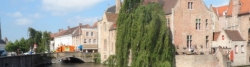
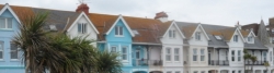
Brugge
Informationen zu Urheber-Rechten | |
|---|---|
Rechte-Inhaber | |
Rechte-Ausprägung / Lizenz | by-sa: CREATIVE COMMONS Namensnennung, Weitergabe unter gleichen Bedingungen |
Link zur Rechtebeschreibung | |
Bild hochgeladen | durch Ottocolor am 04.07.2015
|
112 km
Brugge-Dover
Informationen zu Urheber-Rechten | |
|---|---|
Rechte-Inhaber | |
Rechte-Ausprägung / Lizenz | by-sa: CREATIVE COMMONS Namensnennung, Weitergabe unter gleichen Bedingungen |
Link zur Rechtebeschreibung | |
Bild hochgeladen | durch Ottocolor am 04.07.2015
|
78 km
Dover-Winchelsea
Informationen zu Urheber-Rechten | |
|---|---|
Rechte-Inhaber | |
Rechte-Ausprägung / Lizenz | by-sa: CREATIVE COMMONS Namensnennung, Weitergabe unter gleichen Bedingungen |
Link zur Rechtebeschreibung | |
Bild hochgeladen | durch Ottocolor am 30.07.2015
|
92 km
Winchelsea-Brighton
Informationen zu Urheber-Rechten | |
|---|---|
Rechte-Inhaber | |
Rechte-Ausprägung / Lizenz | by-sa: CREATIVE COMMONS Namensnennung, Weitergabe unter gleichen Bedingungen |
Link zur Rechtebeschreibung | |
Bild hochgeladen | durch Ottocolor am 30.07.2015
|
51 km
Brighton-Littlehampton
Informationen zu Urheber-Rechten | |
|---|---|
Rechte-Inhaber | |
Rechte-Ausprägung / Lizenz | by-sa: CREATIVE COMMONS Namensnennung, Weitergabe unter gleichen Bedingungen |
Link zur Rechtebeschreibung | |
Bild hochgeladen | durch Ottocolor am 31.07.2015
|
80 km
Littlehampton-Portsmouth
Informationen zu Urheber-Rechten | |
|---|---|
Rechte-Inhaber | |
Rechte-Ausprägung / Lizenz | by-sa: CREATIVE COMMONS Namensnennung, Weitergabe unter gleichen Bedingungen |
Link zur Rechtebeschreibung | |
Bild hochgeladen | durch Ottocolor am 31.07.2015
|
66 km
Portsmouth-Quineville
Informationen zu Urheber-Rechten | |
|---|---|
Rechte-Inhaber | |
Rechte-Ausprägung / Lizenz | by-sa: CREATIVE COMMONS Namensnennung, Weitergabe unter gleichen Bedingungen |
Link zur Rechtebeschreibung | |
Bild hochgeladen | durch Ottocolor am 08.08.2015
|
71 km
Quineville-Vierville
Informationen zu Urheber-Rechten | |
|---|---|
Rechte-Inhaber | |
Rechte-Ausprägung / Lizenz | by-sa: CREATIVE COMMONS Namensnennung, Weitergabe unter gleichen Bedingungen |
Link zur Rechtebeschreibung | |
Bild hochgeladen | durch Ottocolor am 09.08.2015
|
33 km
Vierville-Bayeux
Informationen zu Urheber-Rechten | |
|---|---|
Rechte-Inhaber | |
Rechte-Ausprägung / Lizenz | by-sa: CREATIVE COMMONS Namensnennung, Weitergabe unter gleichen Bedingungen |
Link zur Rechtebeschreibung | |
Bild hochgeladen | durch Ottocolor am 10.08.2015
|
61 km
Bayeux-Ouistreham
Informationen zu Urheber-Rechten | |
|---|---|
Rechte-Inhaber | |
Rechte-Ausprägung / Lizenz | by-sa: CREATIVE COMMONS Namensnennung, Weitergabe unter gleichen Bedingungen |
Link zur Rechtebeschreibung | |
Bild hochgeladen | durch Ottocolor am 10.08.2015
|
62 km
Ouistreham-Caen/Paris/Maubeuge-Mons/Brussel
Informationen zu Urheber-Rechten | |
|---|---|
Rechte-Inhaber | |
Rechte-Ausprägung / Lizenz | by-sa: CREATIVE COMMONS Namensnennung, Weitergabe unter gleichen Bedingungen |
Link zur Rechtebeschreibung | |
Bild hochgeladen | durch Ottocolor am 10.08.2015
|
Brussel og transportdag Brussel-Odense
Fahrradfreundliche Unterkünfte, Sehenswertes und Infrastruktur
Name u. Anschrift
Breite / Länge
Tel.
Fax.
Mobile
Art d. Unterkunft
Radler-freund-lichkeit
Strecken-km
km zur Strecke
Höhe
0 km
1,1 km
12 m
1 km
0,4 km
10 m
2 km
0,1 km
14 m
3 km
0,1 km
14 m
![]()